File:Ancient balkans 4thcentury.png
Mine navigeerimisribale
Mine otsikasti

Selle eelvaate suurus: 790 × 600 pikslit. Teised eraldusvõimed: 316 × 240 pikslit | 632 × 480 pikslit | 1012 × 768 pikslit | 1113 × 845 pikslit.
Algfail (1113 × 845 pikslit, faili suurus: 88 KB, MIME tüüp: image/png)
Pealdised
Pealdised
Lisa üherealine seletus sellest, mida fail esitab
| Kirjeldus |
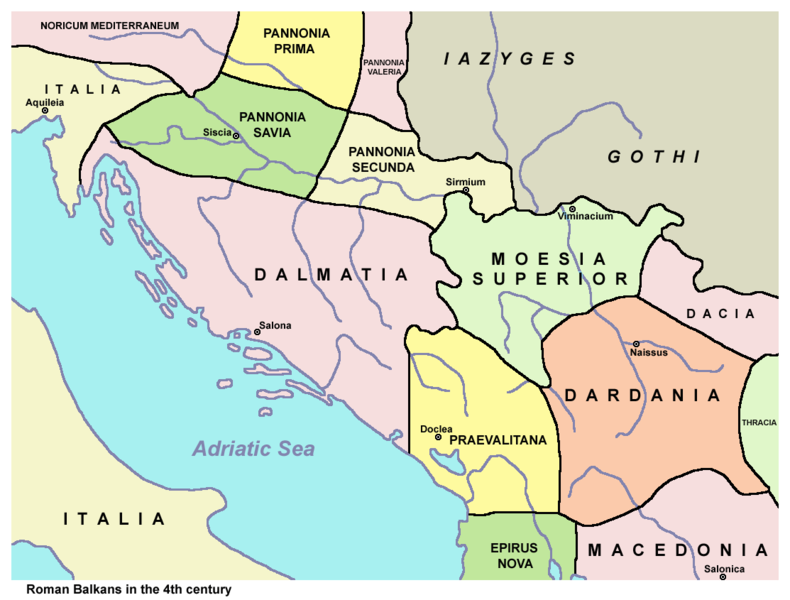
English: Ancient Roman Balkans in the 4th century. Српски / srpski: Antički rimski Balkan u 4. veku. |
| Kuupäev | |
| Allikas | Üleslaadija oma töö. Based on data from published sources and web sources. See References below. |
| Autor | PANONIAN |
| Teised versioonid |
[]
|


Litsents[muuda]
| Autor PANONIAN inglise Vikipeediast on andnud selle teose avalikku omandisse. See kehtib üleilmselt. Kui see pole mõnes riigis õiguslikult võimalik: PANONIAN annab kõigile õiguse seda teost kasutada ükskõik mille jaoks, ilma ühegi tingimuseta, kui seadus neid just ei sea. |
References[muuda]
- Sima M. Ćirković, Srbi među evropskim narodima, Beograd, 2004.
- Denis Šehić - Demir Šehić, Istorijski atlas Sveta, Beograd, 2007.
- http://www.euratlas.net/history/europe/300/europe_map_0300.html
- http://xxlworld.xx.ohost.de/povijest/slike/mape/3-5cen.jpg[dead link]
- http://www.geocities.ws/lajme8reja/1111111111dardania.JPG
- http://www.orbilat.com/Maps/Latin/Balkan_Latin.gif
- http://soltdm.com/geo/arts/delta/hierocl.jpg
Esialgne üleslaadimislogi[muuda]
Esialgne kirjelduslehekülg oli siin. Kõik järgmised kasutajanimed viitavad projektile en.wikipedia.
Faili ajalugu
Klõpsa kuupäeva ja kellaaega, et näha sel ajahetkel kasutusel olnud failiversiooni.
| Kuupäev/kellaaeg | Pisipilt | Mõõtmed | Kasutaja | Kommentaar | |
|---|---|---|---|---|---|
| viimane | 25. november 2013, kell 21:40 | | 1113 × 845 (88 KB) | PANONIAN (arutelu | kaastöö) | aesthetics |
| 8. aprill 2010, kell 11:34 |  | 1115 × 845 (88 KB) | PANONIAN (arutelu | kaastöö) | Reverted to version as of 11:22, 8 April 2010 - fixing thumbnail problem | |
| 8. aprill 2010, kell 11:32 |  | 1115 × 845 (89 KB) | PANONIAN (arutelu | kaastöö) | Reverted to version as of 00:04, 7 March 2010 - fixing thumbnail problem | |
| 8. aprill 2010, kell 11:22 |  | 1115 × 845 (88 KB) | PANONIAN (arutelu | kaastöö) | correction | |
| 7. märts 2010, kell 00:04 |  | 1115 × 845 (89 KB) | PANONIAN (arutelu | kaastöö) | corrected mistake | |
| 6. märts 2010, kell 23:24 |  | 1115 × 845 (89 KB) | PANONIAN (arutelu | kaastöö) | improved version | |
| 4. september 2009, kell 13:01 |  | 1300 × 943 (113 KB) | Penn Station (arutelu | kaastöö) | {{Information |Description=Own work by authors(PANONIAN, Olahus). Ancient balkans 4thcentury. |Source=File:Ancient balkans 4thcentury.png |Date=19:53, 7 March 2008 |Author=PANONIAN, Olahus |Permission= |other_versions= }} {{PD-user-en|PANONIAN, Olahus}} |
Sa ei saa seda faili üle kirjutada.
Faili kasutus
Seda faili kasutavad järgmised 15 lehekülge:
- Atlas of Albania
- Atlas of Bosnia and Herzegovina
- Atlas of Croatia
- Atlas of Kosovo
- Atlas of Montenegro
- Atlas of Republika Srpska
- Atlas of Serbia
- Atlas of Vojvodina
- Illyria and Illyrians
- User:Penn Station
- File:Ancient balkans 4thcentury-es.svg
- File:Ancient balkans 4thcentury-sr.png
- File:Ancient balkans 4thcentury-zh.svg
- File:Ancient balkans 4thcentury.png
- Template:Other versions/Ancient balkans 4thcentury
Globaalne failikasutus
Järgmised muud vikid kasutavad seda faili:
- Faili kasutus vikis an.wikipedia.org
- Faili kasutus vikis ar.wikipedia.org
- Faili kasutus vikis azb.wikipedia.org
- Faili kasutus vikis az.wikipedia.org
- Faili kasutus vikis be.wikipedia.org
- Faili kasutus vikis bg.wikipedia.org
- Faili kasutus vikis bn.wikipedia.org
- Faili kasutus vikis br.wikipedia.org
- Faili kasutus vikis bs.wikipedia.org
- Faili kasutus vikis ca.wikipedia.org
- Faili kasutus vikis cs.wikipedia.org
- Faili kasutus vikis de.wikipedia.org
- Faili kasutus vikis el.wikipedia.org
- Faili kasutus vikis en.wikipedia.org
Vaata selle faili globaalset kasutust.
Kategooriad:
- Maps of the history of the ancient Balkans
- Maps of the history of Croatia in ancient times
- Maps of the history of Dalmatia
- Maps of the history of Slavonia
- Maps of the history of Bosnia and Herzegovina in ancient times
- Maps of the history of Montenegro in ancient times
- Maps of the history of Serbia in ancient times
- Maps of the history of Vojvodina
- Maps of the history of Syrmia
- Maps of the history of Kosovo in ancient times
- Maps of the history of Albania in ancient times
- Maps of the history of North Macedonia in ancient times
- Roman provinces (Balkans)
- Maps of Illyricum
- Maps of Roman Dalmatia
- Maps of Roman Praevalitana
- Maps of Roman Pannonia
- Moesia Prima
- Dardania (Roman Empire)
- Dacia Aureliana
- Maps of the Goths
- Iazyges
- Liburnians