File:Ancona - mappa del rione Capodimonte.png
Jump to navigation
Jump to search
Size of this preview: 545 × 600 pixels. Other resolutions: 218 × 240 pixels | 436 × 480 pixels | 776 × 854 pixels.
Original file (776 × 854 pixels, file size: 478 KB, MIME type: image/png)
Captions
Captions
Add a one-line explanation of what this file represents
Summary
[edit]
| Description |
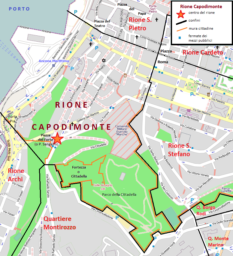
Italiano: Mappa del rione Capodimonte di Ancona, con i confini, le vie, le piazze e i parchi. |
| Date | |
| Source | Base cartografica da Openstreetmap modificata da me |
| Author | sono io l'autore |
| Permission (Reusing this file) |
libera |
Licensing
[edit]
Gep at Italian Wikipedia, the copyright holder of this work, hereby publishes it under the following licenses:

|
Permission is granted to copy, distribute and/or modify this document under the terms of the GNU Free Documentation License, Version 1.2 or any later version published by the Free Software Foundation; with no Invariant Sections, no Front-Cover Texts, and no Back-Cover Texts. A copy of the license is included in the section entitled GNU Free Documentation License. |
This file is licensed under the Creative Commons Attribution-Share Alike 3.0 Unported, 2.5 Generic, 2.0 Generic and 1.0 Generic license.
Attribution: Gep at Italian Wikipedia
- You are free:
- to share – to copy, distribute and transmit the work
- to remix – to adapt the work
- Under the following conditions:
- attribution – You must give appropriate credit, provide a link to the license, and indicate if changes were made. You may do so in any reasonable manner, but not in any way that suggests the licensor endorses you or your use.
- share alike – If you remix, transform, or build upon the material, you must distribute your contributions under the same or compatible license as the original.
You may select the license of your choice.
Original upload log
[edit]
The original description page was here. All following user names refer to it.wikipedia.
| Date/Time | Dimensions | User | Comment |
|---|---|---|---|
| 2013-02-16 18:35 | 776×854× (489420 bytes) | Gep | Inserisco il percorso delle mura cittadine |
| 2013-02-16 09:39 | 776×854× (488178 bytes) | Gep | colori |
| 2013-02-05 21:07 | 776×854× (484476 bytes) | Gep | Legenda (mancava) |
| 2013-02-05 20:57 | 776×854× (513056 bytes) | Gep | == Dettagli == {{Informazioni file |Descrizione = Mappa del rione Capodimonte di Ancona, con i confini, le vie, le piazze e i parchi. |Fonte = Base cartografica da [http://www.openstreetmap.org/ Openstreetmap] modificata da me |Data = 4 febbraio 2013 ... |
File history
Click on a date/time to view the file as it appeared at that time.
| Date/Time | Thumbnail | Dimensions | User | Comment | |
|---|---|---|---|---|---|
| current | 14:10, 12 November 2015 | | 776 × 854 (478 KB) | Beta16 (talk | contribs) | Transferred from it.wikipedia |
You cannot overwrite this file.
File usage on Commons
There are no pages that use this file.
File usage on other wikis
The following other wikis use this file:
- Usage on it.wikipedia.org