File:Anglo-Turkish Boundary Commission map of Cape Bab el-Mandeb.jpg
Jump to navigation
Jump to search

Size of this preview: 357 × 599 pixels. Other resolutions: 143 × 240 pixels | 286 × 480 pixels | 457 × 768 pixels | 610 × 1,024 pixels | 1,731 × 2,905 pixels.
Original file (1,731 × 2,905 pixels, file size: 2.93 MB, MIME type: image/jpeg)
Captions
Captions
Add a one-line explanation of what this file represents
Summary
[edit]
| Description |
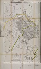
English: Map issued as an annex to the Anglo-Turkish Convention of 3 June 1914. This map of the southwestern tip of the Arabian Peninsula shows the demarcation line agreed upon between 1902 and 1904 by the Anglo-Turkish Boundary Commission which had been tasked to demarcate the respective Ottoman and British spheres of influence in South Arabia. This is one of four maps showing the whole length of the demarcation line drawn by the Commission. The area bordered in yellow, approximately 550 sq. miles, was the area of Yemen that the Turkish government committed not to alienate in any way to a foreign power. Britain was concerned that France, Italy or Germany might attempt to acquire this strategic area facing the British island of Perim at the entrance of the Red Sea. Cape Bab el-Mandeb was also known as Sheikh Said, and is generally known today as Ras Menheli. Français : Carte annexée à la Convention anglo-ottomane du 3 juin 1914 illustrant la ligne de démarcation entre les zones ottomane (à gauche) et britannique à l'extrémité sud-ouest de la péninsule arabique, qui avait été tracée par la Commission de démarcation en 1904. L'extrémité de la péninsule de Cheikh-Saïd est illustrée en gros plan dans le coin inférieur droit. La zone délimitée par une ligne jaune était une zone d'environ 550 miles carrés que la Turquie s'engageait à ne jamais aliéner en faveur d'une puissance étrangère. |
| Date | |
| Source | Qatar Digital Library |
| Author | British War Office, 1914 |
Licensing
[edit]
|
This work is in the public domain in its country of origin and other countries and areas where the copyright term is the author's life plus 100 years or fewer. | |
| This file has been identified as being free of known restrictions under copyright law, including all related and neighboring rights. | |
File history
Click on a date/time to view the file as it appeared at that time.
| Date/Time | Thumbnail | Dimensions | User | Comment | |
|---|---|---|---|---|---|
| current | 16:41, 16 November 2015 | | 1,731 × 2,905 (2.93 MB) | Lubiesque (talk | contribs) | User created page with UploadWizard |
You cannot overwrite this file.
File usage on Commons
There are no pages that use this file.
File usage on other wikis
The following other wikis use this file:
- Usage on fr.wikipedia.org