File:Antalya districts.png
跳转到导航
跳转到搜索
本预览的尺寸:736 × 599像素。 其他分辨率:295 × 240像素 | 589 × 480像素 | 954 × 777像素。
原始文件 (954 × 777像素,文件大小:46 KB,MIME类型:image/png)
说明
说明
添加一行文字以描述该文件所表现的内容
摘要
[编辑]
| 描述 |
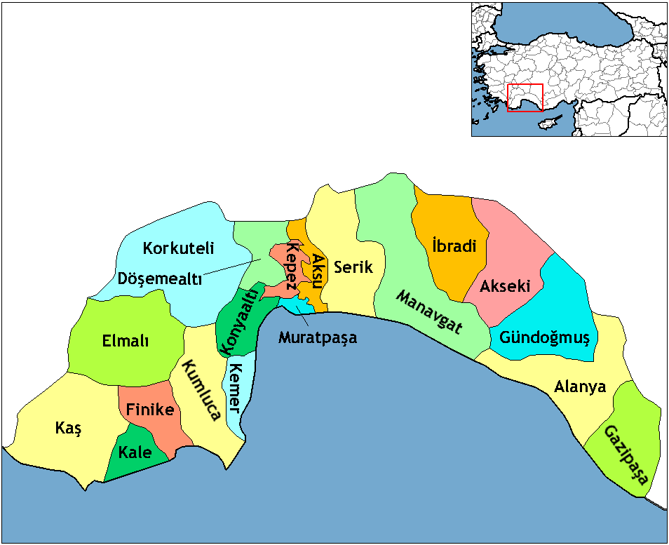
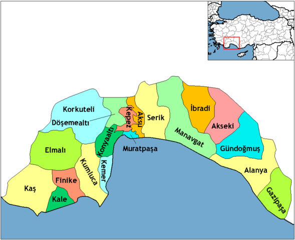
English: Map of the districts of Antalya province in Turkey. Created by Rarelibra 16:59, 1 December 2006 (UTC) for public domain use, using MapInfo Professional v8.5 and various mapping resources. Edited by One Homo Sapiens Corrected text where İ,Ş,ı,ğ,or ş occurs in name. Source: [statoids-com]. Increased font size and enhanced color differences among adjacent districts. |
| 日期 | 2006年12月1日 (原始上传日期) |
| 来源 | 无法识别来源。根据版权声明推断为其自己的作品。 |
| 作者 | 无法识别作者。根据版权声明推断作者为Rarelibra。 |
许可协议
[编辑]
| 我,本作品著作权人,释出本作品至公有领域。这适用于全世界。 在一些国家这可能不合法;如果是这样的话,那么: 我无条件地授予任何人以任何目的使用本作品的权利,除非这些条件是法律规定所必需的。 |
This image was intentionally uploaded with a border. Please do not remove the border. Upload a new version under a different filename without a border if you want a version without a border.
|
文件历史
点击某个日期/时间查看对应时刻的文件。
| 日期/时间 | 缩略图 | 大小 | 用户 | 备注 | |
|---|---|---|---|---|---|
| 当前 | 2018年2月18日 (日) 23:24 | | 954 × 777(46 KB) | Effeietsanders(留言 | 贡献) | Removed border by cropping 10 % horizontally and 5 % vertically using CropTool with precise mode. |
| 2009年1月1日 (四) 19:18 |  | 1,056 × 816(67 KB) | Onur(留言 | 贡献) | {{Information |Description= |Source= |Date= |Author= |Permission= |other_versions= }} | |
| 2008年12月28日 (日) 20:43 |  | 1,056 × 816(39 KB) | One Homo Sapiens(留言 | 贡献) | Corrected text where İ,Ş,ı,ğ,or ş occurs in name. Source: [statoids-com]. Increased font size and enhanced color differences among adjacent districts. | |
| 2006年12月1日 (五) 16:59 |  | 1,056 × 816(32 KB) | Rarelibra(留言 | 贡献) | Map of the districts of Antalya province in Turkey. Created by ~~~~ for public domain use, using MapInfo Professional v8.5 and various mapping resources. |
您不可以覆盖此文件。
文件用途
以下11个页面使用本文件:
- Districts of Turkey
- User:Lord Leatherface
- Category:Antalya Province
- Category:Births in Antalya Province
- Category:Burials in Antalya
- Category:Castles in Antalya Province
- Category:Dams in Antalya Province
- Category:Maps of Antalya Province
- Category:Oba, Alanya
- Category:People of Antalya Province
- Category:Populated places in Antalya Province
全域文件用途
以下其他wiki使用此文件:
- azb.wikipedia.org上的用途
- az.wikipedia.org上的用途
- ba.wikipedia.org上的用途
- be.wikipedia.org上的用途
- br.wikipedia.org上的用途
- ca.wikipedia.org上的用途
- da.wikipedia.org上的用途
- de.wikipedia.org上的用途
- Alanya
- Antalya (Provinz)
- Gazipaşa
- Akseki
- Kumluca (Antalya)
- Vorlage:Navigationsleiste Landkreise der Provinz Antalya
- Serik (Landkreis)
- Korkuteli (Landkreis)
- Finike (Landkreis)
- Elmalı (Landkreis)
- İbradı (Landkreis)
- Kemer (Landkreis, Antalya)
- Kaş (Landkreis)
- Gündoğmuş
- Demre
- Aksu (Antalya)
- Döşemealtı
- Kepez (Antalya)
- Konyaaltı
- Muratpaşa
- diq.wikipedia.org上的用途
- en.wikipedia.org上的用途
查看此文件的更多全域用途。