File:Antarctic Temperature Trend 1981-2007.jpg
Прејди на прегледникот
Прејди на пребарувањето
Нема верзија со поголема разделност.
Antarctic_Temperature_Trend_1981-2007.jpg (540 × 508 пиксели, големина: 93 КБ, MIME-тип: image/jpeg)
Описи
Описи
Опишете во еден ред што претставува податотекава
Опис
[уреди]
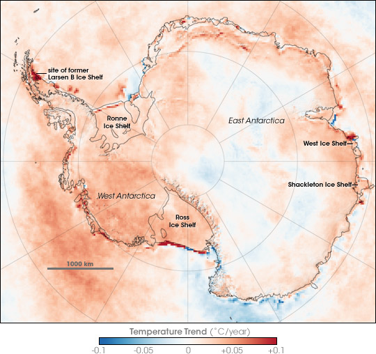
| Опис | Map showing Antarctic Skin Temperature Trends between 1981 and 2007. Skin temperature is roughly the top one millimeter of land, sea, snow, or ice. Across most of the Antarctic the temperature increased, in some areas warming approaching 2 degrees Celsius during the period. The map is based on thermal infrared (heat) observations made by a series of NOAA satellite sensors. None of the sensors were in orbit at the same time, so scientists could not compare simultaneous observations from different sensors to make sure each was recording temperatures exactly the same. Instead, the team checked the satellite records against ground-based weather station data to inter-calibrate them and make the 26-year satellite record. The level of uncertainty is between 2 and 3 degrees Celsius. The most dramatic changes are the red areas associated with iceberg calving and the collapse of the Larsen B ice shelf. In these cases, the satellites saw a change from cold ice to relatively warm open water. |
| Датум | |
| Извор | en:Internet Archive - https://web.archive.org/web/20070823123915/http://earthobservatory.nasa.gov/Newsroom/NewImages/images.php3?img_id=17838 (originally http://earthobservatory.nasa.gov/Newsroom/NewImages/images.php3?img_id=17838 NASA Earth Observatory) |
| Автор | Robert Simmon |
| Други верзии | العربيَّة |
Лиценцирање
[уреди]
| Оваа податотека е во јавна сопственост бидејќи нејзин создавач е НАСА. Правилата за авторски права на НАСА велат: „Материјалот на НАСА не е заштитен со авторски права освен ако не е поинаку нагласено“. (Правилата за авторски дела на НАСА или правила за користење на слики од Лабораторијата за реактивен погон (JPL)). | ||
 |
Предупредувања:
|
Историја на податотеката
Стиснете на датум/време за да ја видите податотеката како изгледала тогаш.
| Датум/време | Минијатура | Димензии | Корисник | Коментар | |
|---|---|---|---|---|---|
| тековна | 22:13, 21 ноември 2007 | | 540 × 508 (93 КБ) | Sagredo (разговор | придонеси) | {{Information |Description=Map showing Antarctic Skin Surface Temperature Trends 1981-2007. Skin temperature is roughly the top one millimeter of land, sea, snow, or ice. Across most of the Antarctic the temperature increased, in some areas approachi |
Не можете да презапишете врз податотекава.
Употреба на податотеката
Податотекава се користи во следнава страница:
Глобална употреба на податотеката
Оваа податотека ја користат и следниве викија:
- Употреба на ar.wikipedia.org
- Употреба на ast.wikipedia.org
- Употреба на ca.wikipedia.org
- Употреба на el.wikipedia.org
- Употреба на en.wikipedia.org
- Употреба на eo.wikipedia.org
- Употреба на es.wikipedia.org
- Употреба на gl.wikipedia.org
- Употреба на ja.wikipedia.org
- Употреба на mk.wikipedia.org
- Употреба на nl.wikipedia.org
- Употреба на nn.wikipedia.org
- Употреба на pa.wikipedia.org
- Употреба на pl.wikipedia.org
- Употреба на ur.wikipedia.org
- Употреба на vi.wikipedia.org
- Употреба на zh.wikipedia.org