File:Appalachian Mountains and Chesapeake Bay (MODIS).jpg

Original file (2,203 × 1,585 pixels, file size: 1.58 MB, MIME type: image/jpeg)
Captions
Captions
Summary[edit]
.jpg&action=edit§ion=1)
| Description |
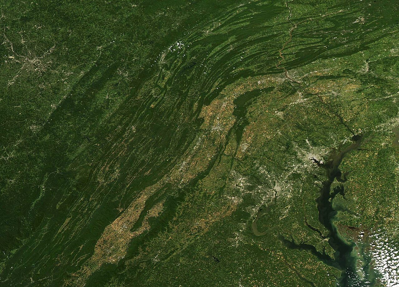
English: On September 15, 2023, the Moderate Resolution Imaging Spectroradiometer (MODIS) on board NASA’s Terra satellite acquired a true-color image of a sunny summer day across several Mid-Atlantic states.
The image is centered on the curving folds of the Appalachian Mountains, with a line of gray pixels marking roads and cities along the I-81 corridor. Most of the tan-topped mountain ridges lie in Virginia while the deep green forests to the west are in West Virginia. In the north, the ridges and valleys of the Appalachians cross into Maryland and then turn northeastward into Pennsylvania. A sprawling, spider-web-like area of gray and tan in the northwest (upper left) is Cumberland, Maryland. This town sits along several interstates and waterways in a narrow part of Western Maryland. While the center of Cumberland sits within Maryland, roads that sprawl to the north are in Pennsylvania while those heading southwest and south sit in West Virginia. The heavily-travelled and heavily-populated I-95 corridor stretches along the Piedmont region of Virginia (south) and Maryland (north) before heading northeast. The major metropolitan area visible along I-95 in the south contains Washington, DC (District of Columbia)-the 68.3-square-mile capital city of the United States-as well as major urban areas such as Alexandria and Reston, Virginia (south) and College Park and Hyattsville, Maryland in the north. The other large gray-pixeled urban center is Baltimore, Maryland. To the east, the Chesapeake Bay separates the Western Shore of Maryland and Virginia from the Eastern Shore. Delaware sits on the eastern edge of the image. The peninsula created by the Chesapeake Bay is known as the Delmarva Peninsula, as it is shared by Delaware, Maryland, and Virginia. |
||
| Date | Taken on 15 September 2023 | ||
| Source |
Appalachian Mountains and Chesapeake Bay (direct link)
|
||
| Author | MODIS Land Rapid Response Team, NASA GSFC |
| This media is a product of the Aqua mission Credit and attribution belongs to the mission team, if not already specified in the "author" row |
Licensing[edit]
.jpg&action=edit§ion=2)
| This file is in the public domain in the United States because it was solely created by NASA. NASA copyright policy states that "NASA material is not protected by copyright unless noted". (See Template:PD-USGov, NASA copyright policy page or JPL Image Use Policy.) | ||
 |
Warnings:
|
File history
Click on a date/time to view the file as it appeared at that time.
| Date/Time | Thumbnail | Dimensions | User | Comment | |
|---|---|---|---|---|---|
| current | 05:05, 14 October 2023 | | 2,203 × 1,585 (1.58 MB) | OptimusPrimeBot (talk | contribs) | #Spacemedia - Upload of http://modis.gsfc.nasa.gov/gallery/images/image10142023_250m.jpg via Commons:Spacemedia |
You cannot overwrite this file.
File usage on Commons
There are no pages that use this file.
.jpg&oldid=813822302)