File:Argentina - Político (regiones).png
Original file (568 × 937 pixels, file size: 23 KB, MIME type: image/png)
Captions
Captions
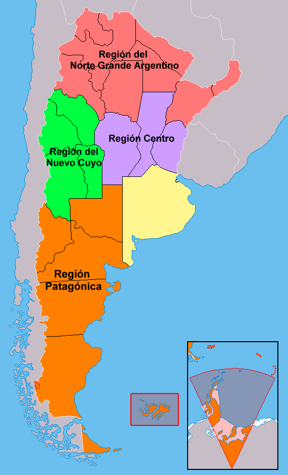
| Description | Mapa de Argentina. Regiones |
| Date | |
| Source | Own work over http://commons.wikimedia.org/wiki/Image:Argentina_-_Pol%C3%ADtico_2.png |
| Author | Pepe Robles |
| Permission (Reusing this file) |
no need. PD. Ownd work |
| Other versions | Derivative works of this file: Regiones de Argentina.svg |
Summary
[edit].png&action=edit§ion=1)
Mapa de las regiones institucionalmente formadas entre provincial en la República Argentina. Cada región está integrada por varias provincias autónomas (estados). La provincia de Buenos Aires y la Ciudad de Buenos Aires, en amarillo, no pertenecen a ninguna región.mm buenos aires y la pampa no pertenecen a la pampa humeda y seca respectivamente?
Los territorios de las Islas Malvinas (Falkland Island) están bajo administración del Reino Unido de Gran Bretaña, aunque la Argentina reclama el control de las mismas. Además, Argentina también reclama el ejercicio de la soberanía sobre una porción de la Antártida (asimismo reclamado por Gran Bretaña y Chile, aunque entre distintos meridianos), pero por el momento este último reclamo está suspendido en virtud del Tratado Antártico Internacional hasta el año 2041.Ambos territorios se consideran parte de la provincia de Tierra del Fuego.
Licensing
[edit].png&action=edit§ion=2)
| I, the copyright holder of this work, release this work into the public domain. This applies worldwide. In some countries this may not be legally possible; if so: I grant anyone the right to use this work for any purpose, without any conditions, unless such conditions are required by law. |
File history
Click on a date/time to view the file as it appeared at that time.
| Date/Time | Thumbnail | Dimensions | User | Comment | |
|---|---|---|---|---|---|
| current | 00:34, 19 November 2017 | | 568 × 937 (23 KB) | Janitoalevic (talk | contribs) | Better provincial borders. |
| 17:55, 18 November 2017 |  | 568 × 937 (23 KB) | Janitoalevic (talk | contribs) | . | |
| 05:39, 3 December 2012 |  | 568 × 937 (51 KB) | CHUCAO (talk | contribs) | Retiré un falso fiordo del Pacífico que tocaba el noroeste de la provincia de Santa Cruz. Rectifiqué algunos límites provinciales compuestos por líneas rectas. Sumé la isla Picton (chilena) pues sólo había mar allí. Retiré el área acordada c... | |
| 18:28, 2 January 2007 |  | 568 × 937 (38 KB) | Roblespepe (talk | contribs) | {{Information |Description= Mapa de Argentina. Regiones |Source= Own work over http://commons.wikimedia.org/wiki/Image:Argentina_-_Pol%C3%ADtico_2.png |Date=2007 |Author=Pepe Robles |Permission=no need. PD. Ownd work |other_versions=none }} == Sumario == |
You cannot overwrite this file.
File usage on Commons
The following page uses this file:
File usage on other wikis
The following other wikis use this file:
- Usage on de.wikipedia.org
- Usage on es.wikipedia.org
- Usage on rm.wikipedia.org
- Usage on ru.wikipedia.org
.png&oldid=801217348)