File:Arques drainage basin-fr.svg
跳至導覽
跳至搜尋

此 SVG 檔案的 PNG 預覽的大小:685 × 599 像素。 其他解析度:274 × 240 像素 | 549 × 480 像素 | 878 × 768 像素 | 1,171 × 1,024 像素 | 2,342 × 2,048 像素 | 2,258 × 1,975 像素。
原始檔案 (SVG 檔案,表面大小:2,258 × 1,975 像素,檔案大小:2 MB)
說明
說明
添加單行說明來描述出檔案所代表的內容
摘要
[編輯]
| 描述 |
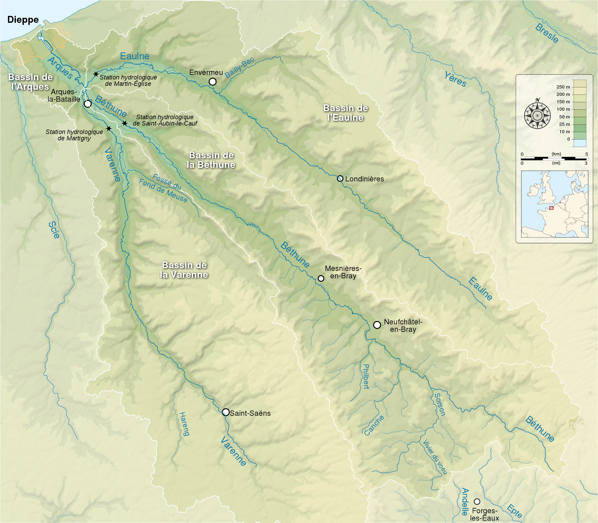
English: Map showing the drainage basin of the Arques river and its three tributaries : the Eaulne, the Béthune and the Varenne. Seine-Maritime, Normandy, France. Français : Carte montrant le bassin versant de l'Arques et de ses trois rivières tributaires : l'Eaulne, la Béthune et la Varenne. Seine-Maritime, Normandie, France. |
| 日期 | (UTC) |
| 來源 |
English:
Français :
|
| 作者 | |
| 姓名標示 (由许可协议要求) | © Sémhur / Wikimedia Commons / |
| SVG開發 | 這個SVG 檔案使用了內置文字,可以使用任何文字編輯器輕鬆翻譯。 |
| 拍攝地點 | | 位於此地的本圖片與其他圖片: OpenStreetMap |
|---|
授權條款
[編輯]
我,本作品的著作權持有者,決定用以下授權條款發佈本作品:
| 公共版權:本藝術作品是自由的,您可以依據自由藝術作品許可協議的條款傳播和/或修改本藝術作品。您可以在Copyleft Attitude網站或其他網站找到該許可協議的樣本。 |
This file is licensed under the Creative Commons Attribution-Share Alike Attribution-Share Alike 4.0 International, 3.0 Unported, 2.5 Generic, 2.0 Generic and 1.0 Generic license.
- 您可以自由:
- 分享 – 複製、發佈和傳播本作品
- 重新修改 – 創作演繹作品
- 惟需遵照下列條件:
- 姓名標示 – 您必須指名出正確的製作者,和提供授權條款的連結,以及表示是否有對內容上做出變更。您可以用任何合理的方式來行動,但不得以任何方式表明授權條款是對您許可或是由您所使用。
- 相同方式分享 – 如果您利用本素材進行再混合、轉換或創作,您必須基於如同原先的相同或兼容的條款,來分布您的貢獻成品。
您可以選擇您需要的授權條款。
檔案歷史
點選日期/時間以檢視該時間的檔案版本。
| 日期/時間 | 縮圖 | 尺寸 | 使用者 | 備註 | |
|---|---|---|---|---|---|
| 目前 | 2014年5月22日 (四) 15:18 | | 2,258 × 1,975(2 MB) | Sémhur(留言 | 貢獻) | Valid SVG |
| 2012年9月9日 (日) 20:15 |  | 2,258 × 1,975(2.07 MB) | Sémhur(留言 | 貢獻) | == {{int:filedesc}} == {{Information |Description={{Multilingual description |en= Map showing the drainage basin of the Arques river and its three tributaries : the Eaulne, the Béthune and the Varenne. Seine-Maritime, Normandy, ... |
無法覆蓋此檔案。
檔案用途
沒有使用此檔案的頁面。
全域檔案使用狀況
以下其他 wiki 使用了這個檔案:
- br.wikipedia.org 的使用狀況
- en.wikipedia.org 的使用狀況
- fr.wikipedia.org 的使用狀況
- la.wikipedia.org 的使用狀況
- pt.wikipedia.org 的使用狀況
- ro.wikipedia.org 的使用狀況
- sr.wikipedia.org 的使用狀況
- zh.wikipedia.org 的使用狀況