File:Arshakuni Armenia 150-en.svg
跳转到导航
跳转到搜索

此SVG文件的PNG预览的大小:800 × 470像素。 其他分辨率:320 × 188像素 | 640 × 376像素 | 1,024 × 601像素 | 1,280 × 751像素 | 2,560 × 1,503像素 | 2,717 × 1,595像素。
原始文件 (SVG文件,尺寸为2,717 × 1,595像素,文件大小:850 KB)
说明
说明
添加一行文字以描述该文件所表现的内容
摘要
[编辑]| 描述 |
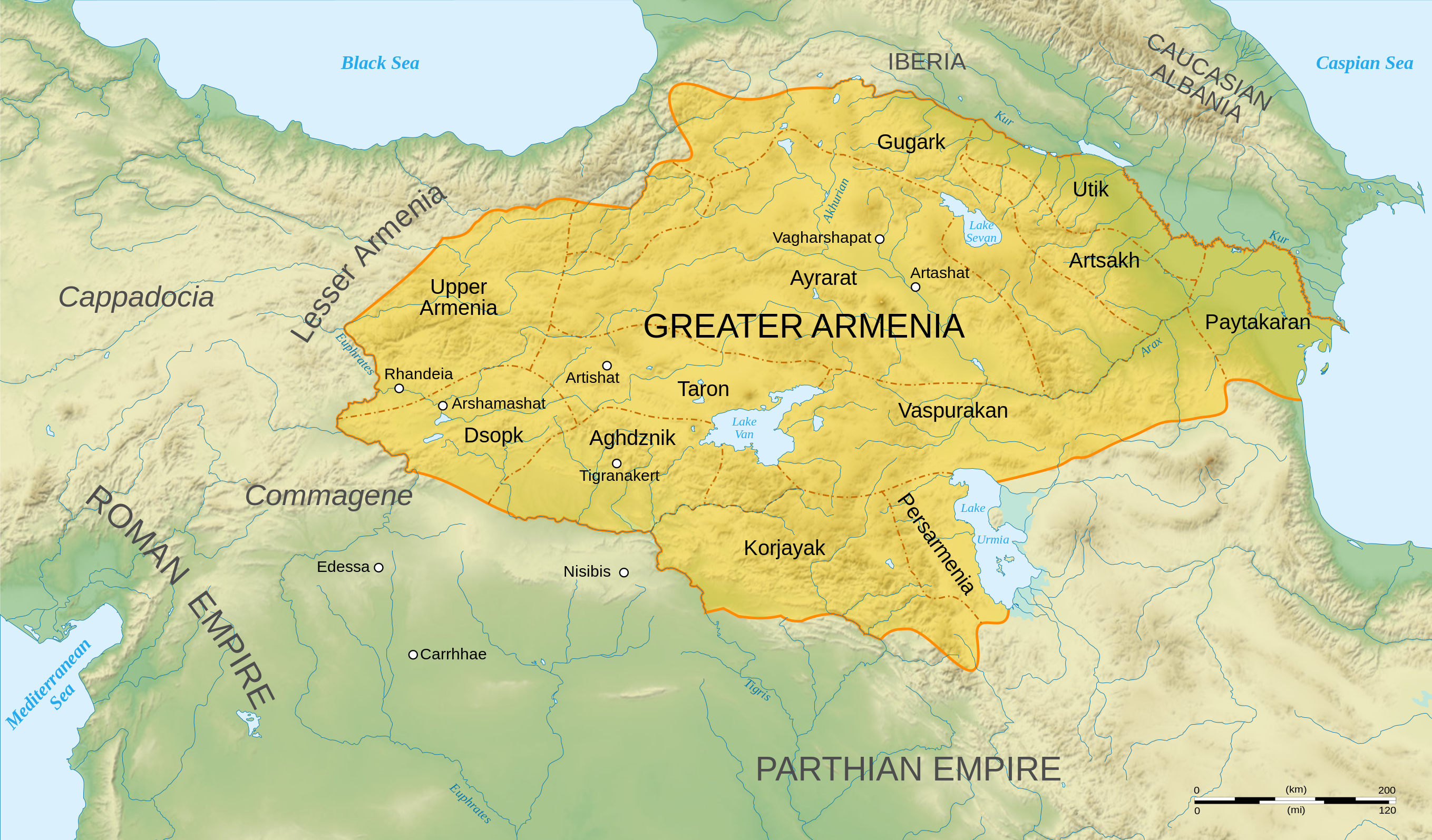
English: Map of Arshakuni Armenia, around the year 150 AD.
Français : Carte en anglais de l'Arménie Arsacide, vers l'an 150. |
||
| 日期 | |||
| 来源 |
Own work.
Sources :
Software used :
Autres données :
|
||
| 作者 | Sémhur | ||
| 其他版本 |
[]
| ||
| 署名 (由许可协议要求) | © Sémhur / Wikimedia Commons / | ||
| SVG | W3C-validity not checked.
|
||
| Atelier graphique |


.png)


| 相机位置 | | 在以下服务上查看本图像和附近其他图像: OpenStreetMap |
|---|
许可协议
[编辑]
我,本作品著作权人,特此采用以下许可协议发表本作品:
| 非营利著作权:本艺术作品是自由的,您可以依据自由艺术作品许可协议的条款传播和/或修改本艺术作品。您可以在Copyleft Attitude网站或其他网站找到该许可协议的样本。 |
This file is licensed under the Creative Commons Attribution-Share Alike Attribution-Share Alike 4.0 International, 3.0 Unported, 2.5 Generic, 2.0 Generic and 1.0 Generic license.
- 您可以自由地:
- 共享 – 复制、发行并传播本作品
- 修改 – 改编作品
- 惟须遵守下列条件:
- 署名 – 您必须对作品进行署名,提供授权条款的链接,并说明是否对原始内容进行了更改。您可以用任何合理的方式来署名,但不得以任何方式表明许可人认可您或您的使用。
- 相同方式共享 – 如果您再混合、转换或者基于本作品进行创作,您必须以与原先许可协议相同或相兼容的许可协议分发您贡献的作品。
您可以选择您需要的许可协议。
文件历史
点击某个日期/时间查看对应时刻的文件。
| 日期/时间 | 缩略图 | 大小 | 用户 | 备注 | |
|---|---|---|---|---|---|
| 当前 | 2023年6月30日 (五) 04:22 | | 2,717 × 1,595(850 KB) | Luckie Luke(留言 | 贡献) | File uploaded using svgtranslate tool (https://svgtranslate.toolforge.org/). Added translation for fa. |
| 2023年6月30日 (五) 01:54 |  | 2,717 × 1,595(808 KB) | Luckie Luke(留言 | 贡献) | File uploaded using svgtranslate tool (https://svgtranslate.toolforge.org/). Added translation for fa. | |
| 2008年1月12日 (六) 12:47 |  | 2,717 × 1,595(798 KB) | Sémhur(留言 | 贡献) | == Description == {{Information |Description= {{en| Map of Arshakuni Armenia, around the year 150 AD.}} {{fr| Carte en anglais de l'Arménie Arsacide, vers l'an 150.}} |Source=Own work. {{clr}} Sources : * Topographic background : [http://www2.jpl.nasa.go |
您不可以覆盖此文件。
文件用途
以下11个页面使用本文件:
- Atlas of Armenia
- Atlas of Artsakh
- User:Magog the Ogre/Multilingual legend/2023 June 21-30
- File:ArshakuniArmenia150.png
- File:Arshakuni Armenia (hy - հայերեն).png
- File:Arshakuni Armenia 150-ca.svg
- File:Arshakuni Armenia 150-en.svg
- File:Arshakuni Armenia 150-es.svg
- File:Arshakuni Armenia 150-fr.svg
- File:Arshakuni Armenia 150-pt.svg
- Template:Other versions/Arshakuni Armenia
全域文件用途
以下其他wiki使用此文件:
- ar.wikipedia.org上的用途
- arz.wikipedia.org上的用途
- azb.wikipedia.org上的用途
- bg.wikipedia.org上的用途
- bn.wikipedia.org上的用途
- de.wikipedia.org上的用途
- diq.wikipedia.org上的用途
- el.wikipedia.org上的用途
- Χοσρόης Α΄ της Αρμενίας
- Τιριδάτης Β΄ της Αρμενίας
- Χοσρόης Β΄ της Αρμενίας
- Τιριδάτης Γ΄ της Αρμενίας
- Χοσρόης Γ΄ της Αρμενίας
- Τιράν της Αρμενίας
- Αρσάκης Β΄ της Αρμενίας
- Παπ της Αρμενίας
- Βαρασδάτης της Αρμενίας
- Αρσάκης Γ΄ της Αρμενίας
- Χοσρόης Δ΄ της Αρμενίας
- Βραχμσαπώρ της Αρμενίας
- Αρταξίας Δ΄ της Αρμενίας
- Τιγράνης ΣΤ΄ της Αρμενίας
- Τιριδάτης Α΄ της Αρμενίας
- Βολογέσης Γ΄ της Παρθίας
- Πρότυπο:Δυναστεία των Αρσακιδών της Αρμενίας
- Δυναστεία των Αρσακιδών της Αρμενίας
- Άνω Αρμενία
- Αρζανηνή
- Γογαρινή
- en.wikipedia.org上的用途
- en.wiktionary.org上的用途
- eo.wikipedia.org上的用途
查看此文件的更多全域用途。