File:Asia 400ad.jpg
跳转到导航
跳转到搜索
本预览的尺寸:800 × 487像素。 其他分辨率:320 × 195像素 | 640 × 389像素 | 1,024 × 623像素 | 1,280 × 779像素 | 1,990 × 1,211像素。
原始文件 (1,990 × 1,211像素,文件大小:790 KB,MIME类型:image/jpeg)
说明
说明
添加一行文字以描述该文件所表现的内容

|
此historical map图片可使用矢量图形重新创建为SVG文件。这具有很多好处;更多信息请参见共享资源:待清理媒体。如果存在此图片的SVG格式,请将其上传,然后将此模板替换为
{{vector version available|新图片名称}}。
建议您将SVG命名为“Asia 400ad.svg”,这样在使用Vector version available(或Vva)模板时就不需要填写新图片名称参数。 |


摘要[编辑]
| 描述 |
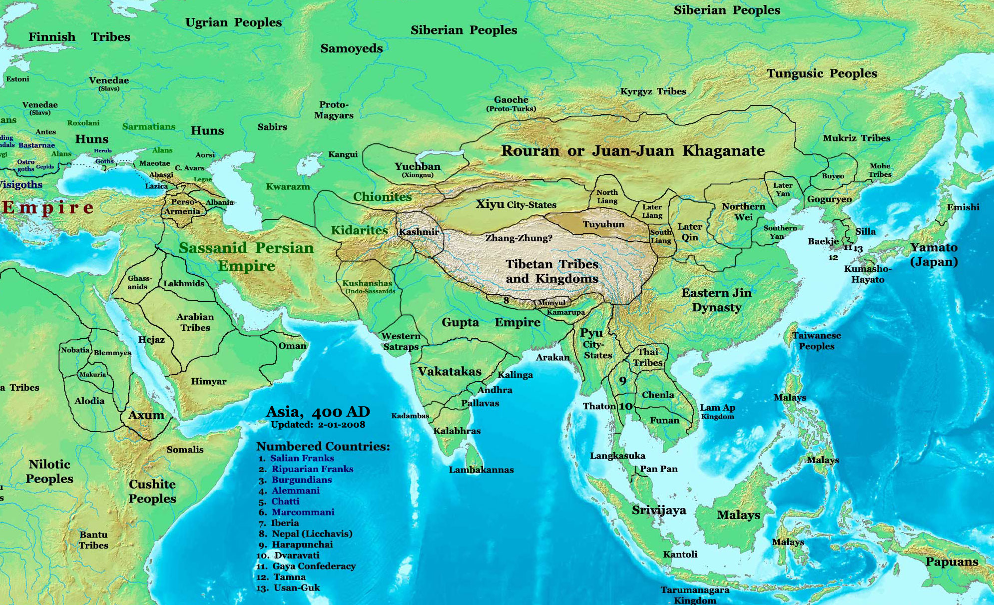
English: Asia in 400 AD |
| 来源 | URL: http://www.ThomasLessman.com/History/images/East-Hem_400ad.jpg |
| 作者 | Thomas A. Lessman, en:User:Talessman |
| 授权 (二次使用本文件) |
Image was created by me (Thomas Lessman) based on map of Eastern Hemisphere in 400 AD. Image is free for public and/or educational use. I would appreciate a mention if this image is used elsewhere. If anyone is interested in helping further this work, please contact Thomas Lessman at talessman@yis.us. |
| 其他版本 | 此文件衍生的作品: |
.jpg)
|
|
此historical map图片可使用矢量图形重新创建为SVG文件。这具有很多好处;更多信息请参见共享资源:待清理媒体。如果存在此图片的SVG格式,请将其上传,然后将此模板替换为
{{vector version available|新图片名称}}。
建议您将SVG命名为“Asia 400ad.svg”,这样在使用Vector version available(或Vva)模板时就不需要填写新图片名称参数。 |
许可协议[编辑]
| 本文件采用知识共享署名-相同方式共享 3.0 未本地化版本许可协议授权。 受免責聲明的約束。 | ||
| ||
| 本许可协议标签作为GFDL许可协议更新的组成部分被添加至本文件。 |

|
已授权您依据自由软件基金会发行的无固定段落及封面封底文字(Invariant Sections, Front-Cover Texts, and Back-Cover Texts)的GNU自由文件许可协议1.2版或任意后续版本的条款,复制、传播和/或修改本文件。该协议的副本请见“GNU Free Documentation License”。 受免責聲明的約束。 |
文件历史
点击某个日期/时间查看对应时刻的文件。
| 日期/时间 | 缩略图 | 大小 | 用户 | 备注 | |
|---|---|---|---|---|---|
| 当前 | 2008年4月6日 (日) 18:27 | | 1,990 × 1,211(790 KB) | Guillem d'Occam(留言 | 贡献) | Author: Thomas A. Lessman. Source URL: [http://www.ThomasLessman.com/History/images/East-Hem_400ad.jpg]. Image was created by me (Thomas Lessman) based on map of Eastern Hemisphere in 400 AD. Image is free for public and/or educational use. I would appr |
您不可以覆盖此文件。
文件用途
以下13个页面使用本文件:
- Atlas of Hungary
- Atlas of Iraqi Kurdistan
- Atlas of Kurdistan
- Atlas of North Ossetia – Alania
- Atlas of South Ossetia
- Atlas of Western Kurdistan
- Atlas of the Levant
- File:Asia 400ad (cropped).jpg
- File:CentralAsia 400ad.jpg
- File:Funan Gupta 400ad.jpg
- File:Map of the Rouran.png
- File:SE Asia 400ad.jpg
- Category:Northern Liang
全域文件用途
以下其他wiki使用此文件:
- azb.wikipedia.org上的用途
- bg.wikipedia.org上的用途
- ca.wikipedia.org上的用途
- cv.wikipedia.org上的用途
- da.wikipedia.org上的用途
- el.wikipedia.org上的用途
- en.wikipedia.org上的用途
- es.wikipedia.org上的用途
- fa.wikipedia.org上的用途
- fi.wikipedia.org上的用途
- fi.wikibooks.org上的用途
- fr.wikipedia.org上的用途
- hak.wikipedia.org上的用途
- hr.wikipedia.org上的用途
- hy.wikipedia.org上的用途
- id.wikipedia.org上的用途
- incubator.wikimedia.org上的用途
- it.wikipedia.org上的用途
- ja.wikipedia.org上的用途
- kk.wikipedia.org上的用途
查看本文件的更多全域用途。
元数据
分类:
- Maps of the Kushan Empire
- Maps of the Sassanid Empire in the 4th century
- Maps of the Gupta Empire
- Maps of the history of Afghanistan
- Maps of the history of Pakistan
- Maps of the history of China
- Maps of the history of Iran
- Maps showing 4th-century history
- Maps of the history of Asia
- Maps of the Huns
- Tai peoples
- Maps of the Kidarites
- Details of the history maps by Thomas A. Lessmann