File:Asia 500ad.jpg

মূল ফাইল (২,১৯৬ × ১,৩০৫ পিক্সেল, ফাইলের আকার: ৪৩৫ কিলোবাইট, এমআইএমই ধরন: image/jpeg)
ক্যাপশনসমূহ
ক্যাপশন

|
This historical map image could be re-created using vector graphics as an SVG file. This has several advantages; see Commons:Media for cleanup for more information. If an SVG form of this image is available, please upload it and afterwards replace this template with
{{vector version available|new image name}}.
It is recommended to name the SVG file “Asia 500ad.svg”—then the template Vector version available (or Vva) does not need the new image name parameter. |


সারাংশ[সম্পাদনা]
| বিবরণ |
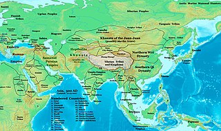
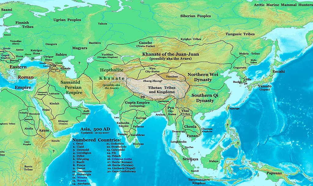
English: Map of the Eastern Hemisphere (partial), centered on Asia in 500 CE, at the turn of the 5th to 6th centuries. |
| তারিখ | ২৩ ডিসেম্বর ২০০৭ (মূল আপলোডের তারিখ) |
| উৎস | en.wikipedia থেকে কমন্সে স্থানান্তরিত করা হয়েছে Chinneeb কর্তৃক CommonsHelper ব্যবহার করে।, original source URL: http://www.ThomasLessman.com/History/images/East-Hem_500ad.jpg. |
| লেখক | Thomas A. Lessman. ইংরেজি উইকিপিডিয়া-এর Talessman |
| অনুমতি (এ ফাইলের পুনঃব্যবহার) |
Image was created by me (Thomas Lessman) based on map of Eastern Hemisphere in 500AD. Image is free for public and/or educational use. I would appreciate a mention if this image is used elsewhere. If anyone is interested in helping further this work, please contact Thomas Lessman at talessman@yis.us. |

লাইসেন্স প্রদান[সম্পাদনা]

|
এই নথি অনুলিপি, বিতরণ এবং/বা পরিবর্তন করার অনুমতি ফ্রি সফটওয়্যার ফাউন্ডেশন কর্তৃক প্রকাশিত গনু ফ্রি ডকুমেন্টেশন লাইসেন্স, সংস্করণ ১.২ বা তার পরবর্তী সংস্করণের আওতায় অনুমতিপ্রাপ্ত; যে কোনো রকম অনুচ্ছেদ পরিবর্তন, সম্মুখ-প্রচ্ছদের লেখা, পিছন-প্রচ্ছদের লেখা পরিবর্তন করা ছাড়াই। এই লাইসেন্সের একটি অনুলিপি গনু ফ্রি ডকুমেন্টেশন লাইসেন্স শিরোনামের অনুচ্ছেদে অন্তর্ভুক্ত করা আছে। |
- আপনি স্বাধীনভাবে:
- বণ্টন করতে পারেন – এ কাজটি অনুলিপি, বিতরণ এবং প্রেরণ করতে পারেন
- পুনঃমিশ্রণ করতে পারেন – কাজটি অভিযোজন করতে পারেন
- নিম্নের শর্তাবলীর ভিত্তিতে:
- স্বীকৃতিপ্রদান – আপনাকে অবশ্যই যথাযথ স্বীকৃতি প্রদান করতে হবে, লাইসেন্সের একটি লিঙ্ক সরবরাহ করতে হবে এবং কোনো পরিবর্তন হয়েছে কিনা তা নির্দেশ করতে হবে। আপনি যেকোনো যুক্তিসঙ্গত পদ্ধতিতে এটি করতে পারেন। কিন্তু এমন ভাবে নয়, যাতে প্রকাশ পায় যে লাইসেন্সধারী আপনাকে বা আপনার এই ব্যবহারের জন্য অনুমোদন দিয়েছে।
Other Maps by Thomas Lessman[সম্পাদনা]
| Maps of the eastern hemisphere showing history
Bold dates are available on Wikimedia or Wikipedia. | ||
| Primeval | ||
| Ancient
|
·| 600 BC | 550 BC | 527 BC | 500 BC |
400 BC | ·| 1 AD | 50 AD | 100 AD | 200 AD | 300 AD | | |
| Medieval |
·| 500 AD | 565 AD | 600 AD | 700 AD | | |
| Modern |
·| 1500 AD | · * For historical maps of the whole world, | |
মূল আপলোড লগ[সম্পাদনা]
- 2007-12-23 15:37 Talessman 2196×1305×??? (445119 bytes) Many corrections and additions, noted on the source map, Image:East-Hem_500ad.jpg.
ফাইলের ইতিহাস
যেকোনো তারিখ/সময়ে ক্লিক করে দেখুন ফাইলটি তখন কী অবস্থায় ছিল।
| তারিখ/সময় | সংক্ষেপচিত্র | মাত্রা | ব্যবহারকারী | মন্তব্য | |
|---|---|---|---|---|---|
| বর্তমান | ০৭:৩৮, ১৫ আগস্ট ২০০৮ | | ২,১৯৬ × ১,৩০৫ (৪৩৫ কিলোবাইট) | File Upload Bot (Magnus Manske) (আলোচনা | অবদান) | {{BotMoveToCommons|en.wikipedia}} {{Information |Description={{en|This image is a zoomed-in version of [http://en.wikipedia.org/wiki/Image:East-Hem_500ad.jpg Eastern Hemisphere in 500 AD]. [[:en:Image:East-Hem_500ad.jpg|thumb|300px|left|Eastern Hemispher |
আপনি এই ফাইলটি প্রতিস্থাপন করতে পারবেন না।
ফাইলের ব্যবহার
নিম্নলিখিত 10টি পাতা এই ফাইল ব্যবহার করে:
ফাইলের বৈশ্বিক ব্যবহার
নিচের অন্যান্য উইকিগুলো এই ফাইলটি ব্যবহার করে:
- azb.wikipedia.org-এ ব্যবহার
- ba.wikipedia.org-এ ব্যবহার
- bg.wikipedia.org-এ ব্যবহার
- bn.wikipedia.org-এ ব্যবহার
- br.wikipedia.org-এ ব্যবহার
- ca.wikipedia.org-এ ব্যবহার
- de.wikipedia.org-এ ব্যবহার
- el.wikipedia.org-এ ব্যবহার
- en.wikipedia.org-এ ব্যবহার
- es.wikipedia.org-এ ব্যবহার
- fa.wikipedia.org-এ ব্যবহার
- fi.wikibooks.org-এ ব্যবহার
- fr.wikipedia.org-এ ব্যবহার
- gu.wikipedia.org-এ ব্যবহার
- he.wikipedia.org-এ ব্যবহার
- hi.wikipedia.org-এ ব্যবহার
- hr.wikipedia.org-এ ব্যবহার
- hu.wikipedia.org-এ ব্যবহার
- hy.wikipedia.org-এ ব্যবহার
এই ফাইলের অন্যান্য বৈশ্বিক ব্যবহার দেখুন।
অধি-উপাত্ত
- Maps of regions showing history by year-spans
- Maps of the world showing history
- Maps of the history of Asia
- Asia in the 5th century
- Asia in the 6th century
- History of Central Asia
- Maps showing 6th-century history
- Maps of the history of Mongolia
- Maps of the history of China
- Maps of the Hephthalites
- Maps of the Sassanid Empire in the 5th century
- Maps of the Gupta Empire
- Northern Wei Dynasty
- China in the 5th century
- China in the 6th century
- Tai peoples
- Yueban
- Maps of the Bashkirs
- Details of the history maps by Thomas A. Lessmann