File:Asia 500ad.jpg

Sākotnējais fails (2 196 × 1 305 pikseļi, faila izmērs: 435 KB, MIME tips: image/jpeg)
Captions
Captions

|
This historical map image could be re-created using vector graphics as an SVG file. This has several advantages; see Commons:Media for cleanup for more information. If an SVG form of this image is available, please upload it and afterwards replace this template with
{{vector version available|new image name}}.
It is recommended to name the SVG file “Asia 500ad.svg”—then the template Vector version available (or Vva) does not need the new image name parameter. |


Kopsavilkums[labot šo sadaļu]
| Apraksts |
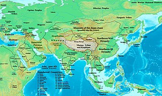
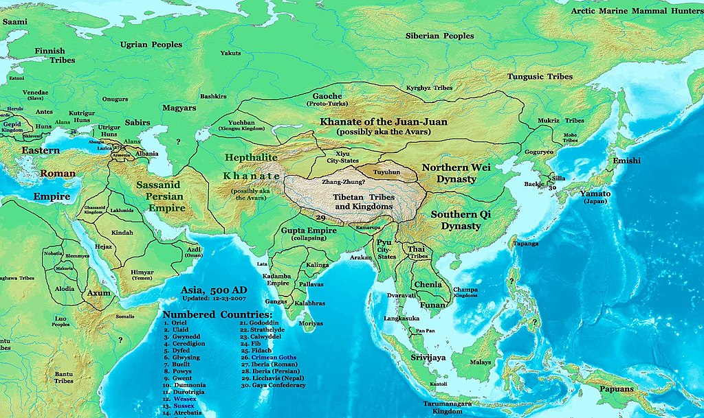
English: Map of the Eastern Hemisphere (partial), centered on Asia in 500 CE, at the turn of the 5th to 6th centuries. |
| Datums | 2007. gada 23. decembris (original upload date) |
| Avots | Transferred from en.wikipedia to Commons by Chinneeb using CommonsHelper., original source URL: http://www.ThomasLessman.com/History/images/East-Hem_500ad.jpg. |
| Autors | Thomas A. Lessman. Talessman at angļu Vikipēdija |
| Atļauja: (Šī faila izmantošana citur) |
Image was created by me (Thomas Lessman) based on map of Eastern Hemisphere in 500AD. Image is free for public and/or educational use. I would appreciate a mention if this image is used elsewhere. If anyone is interested in helping further this work, please contact Thomas Lessman at talessman@yis.us. |

Licence[labot šo sadaļu]

|
Ir dota atļauja kopēt, izplatīt un/vai pārveidot šo dokumentu saskaņā ar GNU brīvās dokumentācijas licences, versijas 1.2 vai jebkuras vēlākas versijas, ko publiskojis Brīvās programmatūras fonds nosacījumiem; bez nemainīgajām sadaļā, priekšējā un aizmugurēja'vāka tekstiem. Licences kopija ir iekļauta sadaļā ar nosaukumu GNU brīvās dokumentācijas licence. |
- Jūs varat brīvi:
- koplietot – kopēt, izplatīt un pārraidīt darbu
- remiksēt – pielāgot darbu
- Saskaņā ar šādiem nosacījumiem:
- atsaucoties – Tev ir jānorāda autors, saite uz licenci un to, vai veiktas kādas izmaiņas. To var darīt jebkādā saprātīgā veidā, bet ne tādā, kas norādītu, ka licencētājs atbalsta tevi vai veidu, kā tu izmanto šo darbu.
Other Maps by Thomas Lessman[labot šo sadaļu]
| Maps of the eastern hemisphere showing history
Bold dates are available on Wikimedia or Wikipedia. | ||
| Primeval | ||
| Ancient
|
·| 600 BC | 550 BC | 527 BC | 500 BC |
400 BC | ·| 1 AD | 50 AD | 100 AD | 200 AD | 300 AD | | |
| Medieval |
·| 500 AD | 565 AD | 600 AD | 700 AD | | |
| Modern |
·| 1500 AD | · * For historical maps of the whole world, | |
Original upload log[labot šo sadaļu]
- 2007-12-23 15:37 Talessman 2196×1305×??? (445119 bytes) Many corrections and additions, noted on the source map, Image:East-Hem_500ad.jpg.
Faila hronoloģija
Uzklikšķini uz datums/laiks kolonnā esošās saites, lai apskatītos, kā šis fails izskatījās tad.
| Datums/Laiks | Attēls | Izmēri | Dalībnieks | Komentārs | |
|---|---|---|---|---|---|
| tagadējais | 2008. gada 15. augusts, plkst. 07.38 | | 2 196 × 1 305 (435 KB) | File Upload Bot (Magnus Manske) (diskusija | devums) | {{BotMoveToCommons|en.wikipedia}} {{Information |Description={{en|This image is a zoomed-in version of [http://en.wikipedia.org/wiki/Image:East-Hem_500ad.jpg Eastern Hemisphere in 500 AD]. [[:en:Image:East-Hem_500ad.jpg|thumb|300px|left|Eastern Hemispher |
Šo failu nevar pārrakstīt.
Faila lietojums
Šo failu izmanto šajās 10 lapās:
Globālais faila lietojums
Šīs Vikipēdijas izmanto šo failu:
- Izmantojums azb.wikipedia.org
- Izmantojums ba.wikipedia.org
- Izmantojums bg.wikipedia.org
- Izmantojums bn.wikipedia.org
- Izmantojums br.wikipedia.org
- Izmantojums ca.wikipedia.org
- Izmantojums de.wikipedia.org
- Izmantojums el.wikipedia.org
- Izmantojums en.wikipedia.org
- Izmantojums es.wikipedia.org
- Izmantojums fa.wikipedia.org
- Izmantojums fi.wikibooks.org
- Izmantojums fr.wikipedia.org
- Izmantojums gu.wikipedia.org
- Izmantojums he.wikipedia.org
- Izmantojums hi.wikipedia.org
- Izmantojums hr.wikipedia.org
- Izmantojums hu.wikipedia.org
- Izmantojums hy.wikipedia.org
Skatīt šī faila pilno globālo izmantojumu.
Metadati
- Maps of regions showing history by year-spans
- Maps of the world showing history
- Maps of the history of Asia
- Asia in the 5th century
- Asia in the 6th century
- History of Central Asia
- Maps showing 6th-century history
- Maps of the history of Mongolia
- Maps of the history of China
- Maps of the Hephthalites
- Maps of the Sassanid Empire in the 5th century
- Maps of the Gupta Empire
- Northern Wei Dynasty
- China in the 5th century
- China in the 6th century
- Tai peoples
- Yueban
- Maps of the Bashkirs
- Details of the history maps by Thomas A. Lessmann