File:Atlantic hurricane tracks.jpg
跳至導覽
跳至搜尋

預覽大小:800 × 448 像素。 其他解析度:320 × 179 像素 | 640 × 359 像素 | 1,024 × 574 像素 | 1,280 × 717 像素 | 2,560 × 1,435 像素 | 9,000 × 5,044 像素。
原始檔案 (9,000 × 5,044 像素,檔案大小:35.69 MB,MIME 類型:image/jpeg)
說明
說明
添加單行說明來描述出檔案所代表的內容
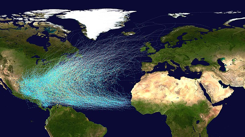
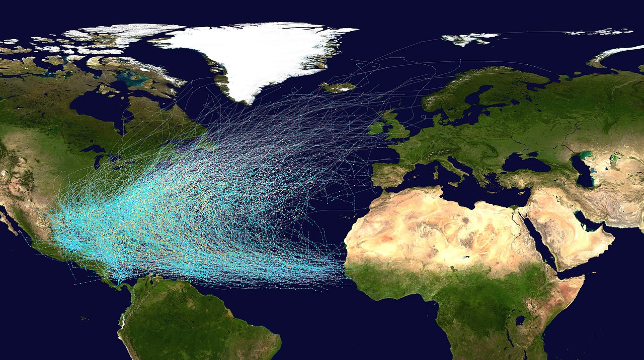
All tropical cyclones in the North Atlantic Ocean from 1851 to 2019.
| Saffir-Simpson Hurricane Scale | ||||||
| TD | TS | 1 | 2 | 3 | 4 | 5 |
摘要[編輯]
| 描述 |
English: This map shows the tracks of all Atlantic hurricanes which formed between 1851 and 2019. The points show the locations of the storms at six-hourly intervals and use the color scheme shown to the right from Saffir-Simpson Hurricane Scale. |
||
| 來源 |
Created using User:jdorje/Tracks by Nilfanion on 2006-08-05. Background image from File:Whole world - land and oceans.jpg (NASA). Tracking data for storms is from the National Hurricane Center.[1] |
||
| 作者 | Nilfanion | ||
| 授權許可 (重用此檔案) |
|
||
| 其他版本 |
本檔案衍生自: Whole world - land and oceans.jpg: |
授權條款[編輯]
| 我,此作品的版權所有人,釋出此作品至公共領域。此授權條款在全世界均適用。 這可能在某些國家不合法,如果是的話: 我授予任何人有權利使用此作品於任何用途,除受法律約束外,不受任何限制。 |
檔案歷史
點選日期/時間以檢視該時間的檔案版本。
| 日期/時間 | 縮圖 | 尺寸 | 用戶 | 備註 | |
|---|---|---|---|---|---|
| 目前 | 2020年8月10日 (一) 02:07 | | 9,000 × 5,044(35.69 MB) | Supportstorm(對話 | 貢獻) | Updated to show years up to 2019 and changes to HURDAT |
| 2013年6月24日 (一) 20:28 |  | 9,000 × 5,562(38.2 MB) | Supportstorm(對話 | 貢獻) | Updated to show years up to 2012 and subsequent changes to HURDAT | |
| 2006年8月5日 (六) 19:34 |  | 4,000 × 2,472(2.61 MB) | Nilfanion(對話 | 貢獻) | == Summary == {|align="{{{align|right}}}" border="0" cellspacing="0" cellpadding="0" style="background:transparent;text-align:center" |- |colspan="7" nowrap="nowrap"| <small>Saffir-Simpson Hurricane Scale</small> |- |s |
無法覆蓋此檔案。
檔案用途
下列3個頁面有用到此檔案:
全域檔案使用狀況
以下其他 wiki 使用了這個檔案:
- ar.wikipedia.org 的使用狀況
- bn.wikipedia.org 的使用狀況
- ckb.wikipedia.org 的使用狀況
- de.wikipedia.org 的使用狀況
- el.wikipedia.org 的使用狀況
- en.wikipedia.org 的使用狀況
- Bermuda Triangle
- Atlantic hurricane
- Wikipedia:WikiProject Tropical cyclones/Project resources
- Hurricane Alley
- Wikipedia:Reference desk/Archives/Science/2009 January 30
- User:Fdizile/All Knowladge
- Wikipedia talk:WikiProject Tropical cyclones/Archive 41
- Wikipedia:WikiProject Tropical cyclones/Atlantic hurricane season good topic
- User:Chicdat/sandbox
- Wikipedia:WikiProject Weather/Project resources
- Wikipedia:WikiProject Weather/Project resources/Tropical cyclone
- Talk:Atlantic hurricane/Archive 1
- es.wikipedia.org 的使用狀況
- eu.wikipedia.org 的使用狀況
- hy.wikipedia.org 的使用狀況
- id.wikipedia.org 的使用狀況
- is.wikipedia.org 的使用狀況
- ms.wikipedia.org 的使用狀況
- nl.wikipedia.org 的使用狀況
- pl.wikipedia.org 的使用狀況
- ru.wikipedia.org 的使用狀況
- simple.wikipedia.org 的使用狀況
- uk.wikipedia.org 的使用狀況
- vi.wikipedia.org 的使用狀況
- www.wikidata.org 的使用狀況
- zh.wikipedia.org 的使用狀況