File:Atlas and plat book of Poweshiek County, Iowa - containing outline map of the county, plats of all the townships with owners' names, plats of all towns in the county, also state auto map, United LOC 2007626747-29.jpg
Jump to navigation
Jump to search

Size of this preview: 451 × 599 pixels. Other resolutions: 180 × 240 pixels | 361 × 480 pixels | 578 × 768 pixels | 770 × 1,024 pixels | 1,870 × 2,485 pixels.
Original file (1,870 × 2,485 pixels, file size: 847 KB, MIME type: image/jpeg)
Captions
Captions
Add a one-line explanation of what this file represents
Summary[edit]
| Description |
English: Available also through the Library of Congress Web site as a raster image. Includes indexes and advertisements. Vendor: John Carbonell (eBay auction) Acquisitions control no. 2006-109 |
||
| Title | Atlas and plat book of Poweshiek County, Iowa : containing outline map of the county, plats of all the townships with owners' names, plats of all towns in the county, also state auto map, United States parcel post map, etc. : compiled from latest data on record. | ||
| Shelf ID | G1433.P8 K4 1914 | ||
| Parent | https://www.loc.gov/resource/g4153pm.gla00078/ | ||
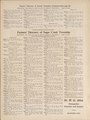
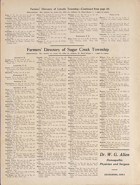
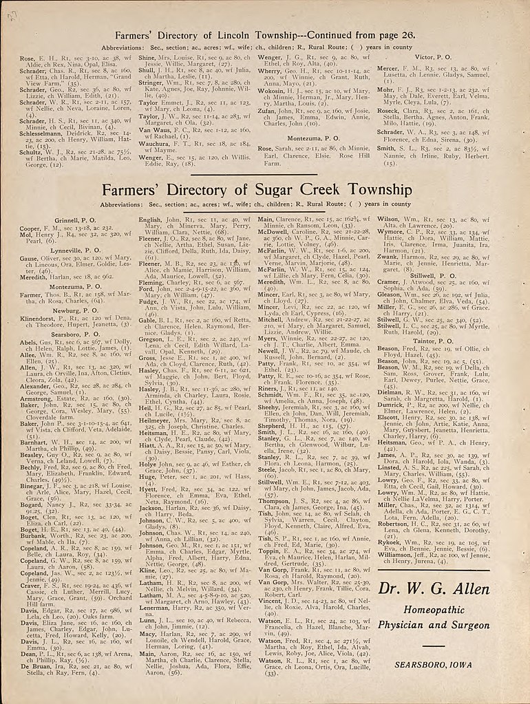
| Sheet title | Farmer's Directory of Sugar Creek Township | ||
| Date | |||
| Source | https://www.loc.gov/item/2007626747/ | ||
| Author | Kenyon Company (Des Moines, Iowa) | ||
| Permission (Reusing this file) |
|
||
| Other versions |
|
||
| Location | United States · Iowa · Poweshiek County | ||
| Part of | American Memory · Catalog · County Landownership Maps · Geography And Map Division · Cultural Landscapes | ||
| Subject | Iowa · Poweshiek County · Poweshiek County (Iowa) · United States · Maps · Real Property · Landowners |

Licensing[edit]
|
This is a faithful photographic reproduction of a two-dimensional, public domain work of art. The work of art itself is in the public domain for the following reason:
The official position taken by the Wikimedia Foundation is that "faithful reproductions of two-dimensional public domain works of art are public domain".
This photographic reproduction is therefore also considered to be in the public domain in the United States. In other jurisdictions, re-use of this content may be restricted; see Reuse of PD-Art photographs for details. | ||||
File history
Click on a date/time to view the file as it appeared at that time.
| Date/Time | Thumbnail | Dimensions | User | Comment | |
|---|---|---|---|---|---|
| current | 11:22, 21 August 2018 | | 1,870 × 2,485 (847 KB) | Fæ (talk | contribs) | LOC Maps multisheet https://www.loc.gov/item/2007626747/ sheet 29 of 48 #83 |
You cannot overwrite this file.
File usage on Commons
The following 2 pages use this file: