File:Atmprofile.jpg
Mine navigeerimisribale
Mine otsikasti
Selle eelvaate suurus: 484 × 600 pikslit. Teised eraldusvõimed: 194 × 240 pikslit | 387 × 480 pikslit | 670 × 830 pikslit.
Algfail (670 × 830 pikslit, faili suurus: 100 KB, MIME tüüp: image/jpeg)
Pealdised
Pealdised
Lisa üherealine seletus sellest, mida fail esitab
Lühikirjeldus
[muuda]| Kirjeldus |
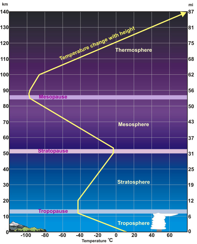
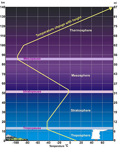
English: Standardized Temperature Profile
An average temperature profile through the lower layers of the atmosphere. Height (in miles and kilometers) is indicated along each side. Temperatures in the thermosphere continue to climb, reaching as high as (3,600°F) 2,000°C. |
| Kuupäev | Kuupäev teadmata |
| Allikas | http://www.srh.noaa.gov/srh/jetstream/atmos/atmprofile.htm |
| Autor | Teadmata |
| Teised versioonid |
|

Litsents
[muuda]
This image is in the public domain because it was stored on the web servers of the U.S. National Weather Service. NWS-created images are automatically public domain in the U.S. since the NWS is a part of the U.S. government. However, the NWS sites also host non-NWS images which have been submitted by individuals: these are generally shown as "Courtesy of ...". Such images have explicitly been released to the public domain by the copyright owner as part of the upload process.
Thus, all* images on NWS servers are public domain (including "Courtesy of ..." and “Photo by ...” images) unless specifically stated otherwise through a copyright (©) watermark.
*A deletion discussion in November 2023 ruled that Getty Images on the web servers of NWS, are to be considered copyrighted, even without a copyright (©) watermark and are the sole exception to this rule.
|
Faili ajalugu
Klõpsa kuupäeva ja kellaaega, et näha sel ajahetkel kasutusel olnud failiversiooni.
| Kuupäev/kellaaeg | Pisipilt | Mõõtmed | Kasutaja | Kommentaar | |
|---|---|---|---|---|---|
| viimane | 11. detsember 2010, kell 12:36 | | 670 × 830 (100 KB) | P.wormer~commonswiki (arutelu | kaastöö) | {{Information |Description={{en|1=Standardized Temperature Profile An average temperature profile through the lower layers of the atmosphere. Height (in miles and kilometers) is indicated along each side. Temperatures in the thermosphere continue to clim |
Sa ei saa seda faili üle kirjutada.
Faili kasutus
Seda faili ei kasuta ükski lehekülg.
Globaalne failikasutus
Järgmised muud vikid kasutavad seda faili: