File:Attack on Harper's Ferrypass5.jpg
Aller à la navigation
Aller à la recherche
Taille de cet aperçu : 526 × 600 pixels. Autres résolutions : 210 × 240 pixels | 421 × 480 pixels | 673 × 768 pixels | 898 × 1 024 pixels | 1 688 × 1 925 pixels.
Fichier d’origine (1 688 × 1 925 pixels, taille du fichier : 2,69 Mio, type MIME : image/jpeg)
Légendes
Légendes
Ajoutez en une ligne la description de ce que représente ce fichier
|
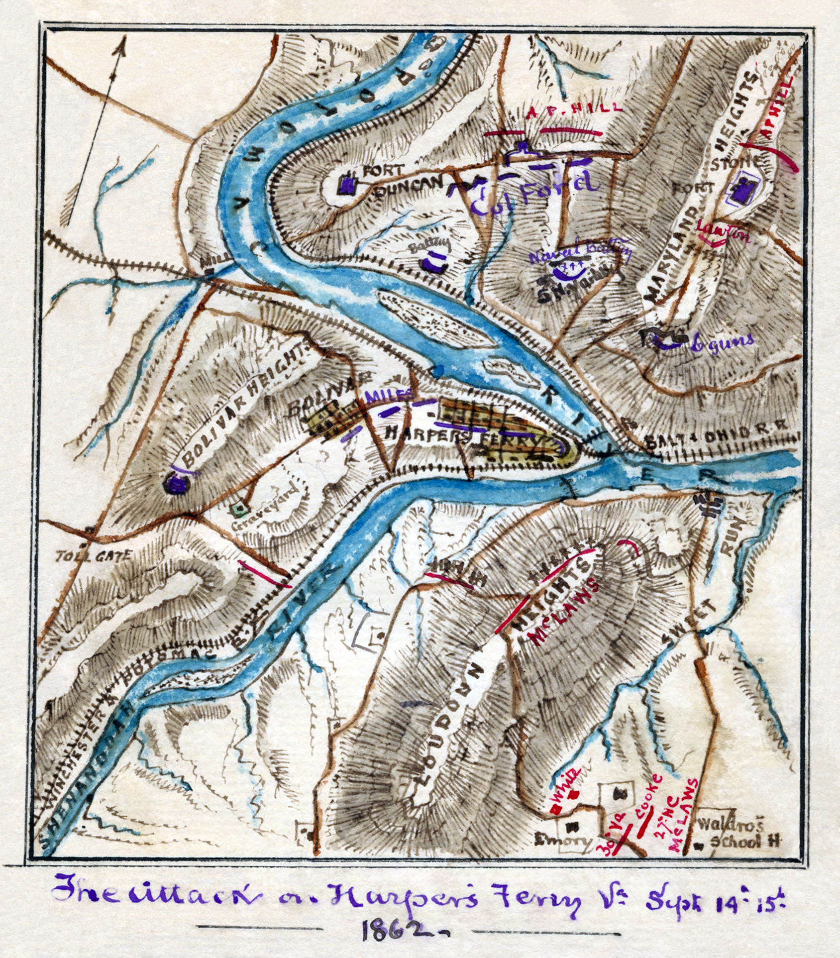
| Description | Scan of a manuscript map by a Union Army mapmaker during the American Civil War. Shows the area surrounding Harper's Ferry, W. Va., at the intersection of the Potomac and Shenandoah Rivers as the Confederate forces under Jackson began their assault, Sept. 12-15, 1862. |
| Date | |
| Source | Library of Congress REPRODUCTION NUMBER Mss5:1 Sn237:1 v. 3 p. 809, In the Robert Knox Sneden Diary (Mss5:1 Sn237:1 v. 3, p. 809). |
| Auteur | Robert Knox Sneden |
| Autres versions | Restored version of Image:attack on Harper's Ferry.jpg. Rotated and cropped, dirt, smudges, and stains removed, levels adjusted, and color balanced. |
| Lieu de la prise de vue | | Voir cet endroit et d’autres images sur : OpenStreetMap |
|---|
| Open this image as an overlay in Google Earth (Google Maps, Bing) | (Help|Source) |
Ce document est dans le domaine public aux États-Unis. Ceci s'applique aux travaux des États-Unis où le copyright a expiré, souvent parce que sa première publication s'est produite avant le 1er janvier 1929. Voir cette page pour davantage d'explication.
|
 | |
 |
Cette image peut ne pas être dans le domaine public en dehors des États-Unis (ceci s'applique particulièrement au Canada, en Chine (pas Hong Kong, Macao, ni Taïwan), en Allemagne ou en Suisse). Le créateur et l'année de la publication sont l'information essentielle et doivent être fournis.
|
Historique du fichier
Cliquer sur une date et heure pour voir le fichier tel qu'il était à ce moment-là.
| Date et heure | Vignette | Dimensions | Utilisateur | Commentaire | |
|---|---|---|---|---|---|
| actuel | 22 juillet 2008 à 18:01 | | 1 688 × 1 925 (2,69 Mio) | Durova (d | contributions) | {{Information |Description=Scan of a manuscript map by a Union Army mapmaker during the American Civil War. Shows the area surrounding Harper's Ferry, W. Va., at the intersection of the Potomac and Shenandoah Rivers as the Confederate forces under Jackso |
Vous ne pouvez pas remplacer ce fichier.
Utilisations locales du fichier
La page suivante utilise ce fichier :
Utilisations du fichier sur d’autres wikis
Les autres wikis suivants utilisent ce fichier :
- Utilisation sur de.wikipedia.org
- Utilisation sur en.wikipedia.org
- Battle of Harpers Ferry
- Portal:North America/Selected picture
- Portal:Maps/Selected picture
- Portal:American Civil War
- Wikipedia:Wikipedia Signpost/2008-08-09/Features and admins
- Wikipedia:Featured pictures thumbs/12
- Wikipedia:Featured picture candidates/Attack on Harper's Ferrypass5.jpg
- Robert Knox Sneden
- Wikipedia:Featured picture candidates/August-2008
- User talk:Durova/Archive 61
- Wikipedia:Wikipedia Signpost/2008-08-09/SPV
- Portal:Maps/Selected picture/47
- Portal:North America/Selected picture/45
- Wikipedia:Picture of the day/February 2009
- Wikipedia:WikiProject Military history/Showcase
- Wikipedia:WikiProject Military history/Showcase/FP
- Template:POTD/2009-02-15
- User talk:Durova/Archive 65
- User:Durova/Featured picture gallery/2008
- Wikipedia:WikiProject United States/Recognized content
- Wikipedia:WikiProject United States/Quality content
- Wikipedia:Featured pictures/History/American Civil War
- Portal:American Civil War/Featured picture
- Wikipedia:WikiProject United States/Featured pictures
- Wikipedia:Wikipedia Signpost/Single/2008-08-09
- Utilisation sur fr.wikipedia.org
- Utilisation sur ja.wikipedia.org
- Utilisation sur kn.wikipedia.org
- Utilisation sur ru.wikipedia.org