File:Australia-climate-map MJC01.png

原始文件 (1,000 × 905像素,文件大小:78 KB,MIME类型:image/png)
说明
说明
摘要[编辑]
| 描述 |
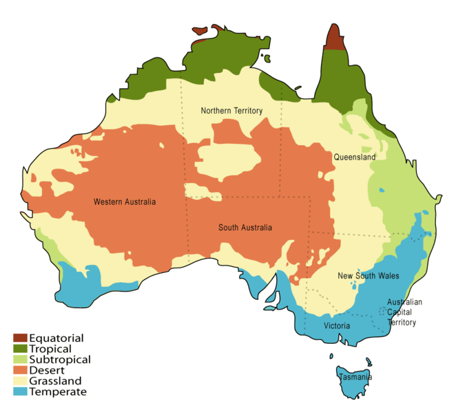
English: The Australian Bureau of Meteorology climate classification, a modification of Köppen's classification. Data from bom.gov.au. |
|||
| 日期 | ||||
| 来源 | 原始上传者自己的作品 | |||
| 作者 | Martyman | |||
| 其他版本 |
Derivative works of this file:
|


许可协议[编辑]
|
NOTE: "subject to disclaimers" below may not actually apply, this was tagged with {{GFDL-user-en}}, and after May 2007, en:Template:GFDL-self did not require disclaimers. Please check the image description page on the English Wikipedia (or, if it has been deleted, ask an English Wikipedia administrator). See Wikipedia:GFDL standardization for details. | ||||||||
| ||||||||
|
Note: This tag should not be used. For images that were released on the English Wikipedia using either GFDL or GFDL-self with disclaimers, use {{GFDL-user-en-with-disclaimers}}. For images without disclaimers please use {{GFDL-user-en-no-disclaimers}} instead. If you are the copyright holder of files that were released on Wikipedia, please consider removing the disclaimers. |

原始上传日志[编辑]
- 02:38, 26 September 2005 . . Martyman (Talk) . . 1000x905 (41677 bytes) (Upload new version at higher resolution and slightly changed colours.)
- 00:15, 26 August 2005 . . Martyman (Talk) . . 800x724 (33965 bytes) (A climate map of Australia drawn be me in Illustrator {{GFDL}})
文件历史
点击某个日期/时间查看对应时刻的文件。
| 日期/时间 | 缩略图 | 大小 | 用户 | 备注 | |
|---|---|---|---|---|---|
| 当前 | 2015年1月28日 (三) 00:13 | | 1,000 × 905(78 KB) | Luxure(留言 | 贡献) | Updated according to BOM map, mainly Tiwi islands and SW WA. |
| 2015年1月28日 (三) 00:05 |  | 1,000 × 905(78 KB) | Luxure(留言 | 贡献) | ||
| 2014年8月12日 (二) 01:54 |  | 1,000 × 905(34 KB) | P. S. Burton(留言 | 贡献) | wikipedia map conventions | |
| 2008年1月1日 (二) 18:45 |  | 1,000 × 905(32 KB) | Mahahahaneapneap(留言 | 贡献) | pngcrushed | |
| 2007年10月25日 (四) 18:45 |  | 1,000 × 905(41 KB) | Denniss(留言 | 贡献) | ||
| 2007年9月3日 (一) 18:03 |  | 662 × 599(149 KB) | Rosarinagazo(留言 | 贡献) | {{Information |Description=A climate map of Australia. Based on a map from the Australian Bureau of Meteorology http://www.bom.gov.au. Australian climate zones - major classification groups (based on the Köppen classification) |Source=http://en.wikipedia | |
| 2006年2月3日 (五) 00:28 |  | 1,000 × 905(41 KB) | Grillo(留言 | 贡献) | A climate map of Australia drawn by me in Illustrator. Based on a map from the Australian Bureau of Meteorology [http://www.bom.gov.au http://www.bom.gov.au]. {{GFDL}} (del) (cur) 02:38, 26 September 2005 . . Martyman (Talk) . . 1000x905 (41677 bytes) ( |
您不可以覆盖此文件。
文件用途
以下7个页面使用本文件:
- User:Daniel Mietchen/Category:Images used by media organizations but violating license terms
- File:Australia-climate-map-uk.svg
- File:Australia-climate-map MJC01 1.svg
- File:Australia-climate-map ru.svg
- File:Climas de Australia.svg
- File:Klimazonen Australiens.svg
- File:Verbreitungsgebiet Wellensittiche.gif
全域文件用途
以下其他wiki使用此文件:
- ast.wikipedia.org上的用途
- az.wikipedia.org上的用途
- bn.wikipedia.org上的用途
- bs.wikipedia.org上的用途
- ca.wikipedia.org上的用途
- ckb.wikipedia.org上的用途
- cs.wikipedia.org上的用途
- en.wikipedia.org上的用途
- eo.wikipedia.org上的用途
- es.wikipedia.org上的用途
- fa.wikipedia.org上的用途
- fy.wikipedia.org上的用途
- ga.wikipedia.org上的用途
- gl.wikipedia.org上的用途
- hi.wikipedia.org上的用途
- hr.wikipedia.org上的用途
- hy.wikipedia.org上的用途
- id.wikipedia.org上的用途
- io.wikipedia.org上的用途
- ja.wikipedia.org上的用途
- ja.wikibooks.org上的用途
- ka.wikipedia.org上的用途
- kk.wikipedia.org上的用途
- kv.wikipedia.org上的用途
- ky.wikipedia.org上的用途
- lt.wikipedia.org上的用途
- lv.wikipedia.org上的用途
- mn.wikipedia.org上的用途
查看此文件的更多全域用途。