File:Australia with AAT (orthographic projection).svg
Jump to navigation
Jump to search

Size of this PNG preview of this SVG file: 600 × 599 pixels. Other resolutions: 240 × 240 pixels | 481 × 480 pixels | 769 × 768 pixels | 1,025 × 1,024 pixels | 2,051 × 2,048 pixels | 791 × 790 pixels.
Original file (SVG file, nominally 791 × 790 pixels, file size: 48 KB)
Captions
Captions
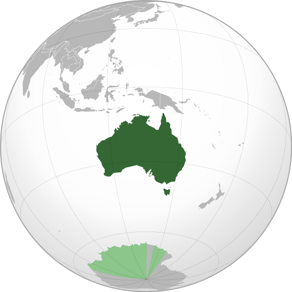
Australia with AAT (orthographic projection)
Summary[edit]
.svg&action=edit§ion=1)
| Description |
English: Australia including the Australian Antarctic Territory |
||
| Date | (UTC) | ||
| Source | File:Australia (orthographic projection).svg | ||
| Author | File:Australia (orthographic projection).svg: Ssolbergj / derivative work Roke | ||
| SVG development |
|
.svg)
Licensing[edit]
.svg&action=edit§ion=2)
I, the copyright holder of this work, hereby publish it under the following licenses:
| This file is licensed under the Creative Commons Attribution-Share Alike 3.0 Unported license. | ||
| ||
| This licensing tag was added to this file as part of the GFDL licensing update. |

|
Permission is granted to copy, distribute and/or modify this document under the terms of the GNU Free Documentation License, Version 1.2 or any later version published by the Free Software Foundation; with no Invariant Sections, no Front-Cover Texts, and no Back-Cover Texts. A copy of the license is included in the section entitled GNU Free Documentation License. |
You may select the license of your choice.
The map has been created with the Generic Mapping Tools: https://www.generic-mapping-tools.org/ using one or more of these public-domain datasets for the relief:
|
|
|
Permission is granted to copy, distribute and/or modify this document under the terms of the GNU Free Documentation License, Version 1.2 or any later version published by the Free Software Foundation; with no Invariant Sections, no Front-Cover Texts, and no Back-Cover Texts. A copy of the license is included in the section entitled GNU Free Documentation License. |
Original upload log[edit]
.svg&action=edit§ion=3)
This image is a derivative work of the following images:
- File:Australia_(orthographic_projection).svg licensed with Cc-by-sa-3.0-migrated, GFDL-GMT
- 2009-08-12T00:17:33Z Addicted04 541x541 (292902 Bytes) Meridianos
- 2008-11-09T13:20:33Z Ssolbergj 541x541 (292870 Bytes) {{Information |Description={{en|1=Australia}} |Source=Own work, [http://www.aquarius.geomar.de/omc/make_map.html Aquarius.geomar.de]{{GFDL-GMT}} |Author=[[User:Ssolbergj|Ssolbergj]] |Date=9 November 2008 |Permissi
Uploaded with derivativeFX
File history
Click on a date/time to view the file as it appeared at that time.
| Date/Time | Thumbnail | Dimensions | User | Comment | |
|---|---|---|---|---|---|
| current | 08:38, 24 March 2020 | | 791 × 790 (48 KB) | Lasunncty (talk | contribs) | fix errors |
| 06:29, 24 June 2016 |  | 791 × 790 (48 KB) | Lasunncty (talk | contribs) | Simplified code | |
| 00:16, 5 February 2010 |  | 541 × 541 (364 KB) | Roke~commonswiki (talk | contribs) | {{Information |Description={{en|1=Australia}} including the Australian Antarctic Territory |Source=*File:Australia_(orthographic_projection).svg |Date=2010-02-05 00:09 (UTC) |Author=*File:Australia_(orthographic_projection).svg: [[User:Ssolber |
You cannot overwrite this file.
File usage
The following 8 pages use this file:
- User:4ing/Antarctica/2016-06
- User:4ing/Antarctica/2020-01-06
- User:Chumwa/OgreBot/Transport Maps/2020 March 21-31
- User:Chumwa/OgreBot/Travel and communication maps/2016 June 21-30
- User:Chumwa/OgreBot/Travel and communication maps/2020 March 21-31
- File:Australia on the globe (+Antarctic claims) (Oceania centered).svg
- File:Australia on the globe (Antarctic claims hatched) (Oceania centered) with borders.svg
- File:German New Guinea (1914; orthographic projection).png
_(Oceania_centered).svg)
_(Oceania_centered)_with_borders.svg)
.png)
Global file usage
The following other wikis use this file:
- Usage on ady.wikipedia.org
- Usage on af.wiktionary.org
- Usage on an.wikipedia.org
- Usage on arc.wikipedia.org
- Usage on av.wikipedia.org
- Usage on azb.wikipedia.org
- Usage on ban.wikipedia.org
- Usage on bcl.wikipedia.org
- Usage on bew.wikipedia.org
- Usage on bg.wikipedia.org
- Usage on bh.wikipedia.org
- Usage on blk.wikipedia.org
- Usage on bn.wikipedia.org
- Usage on csb.wikipedia.org
- Usage on cs.wikipedia.org
- Usage on din.wikipedia.org
- Usage on en.wikipedia.org
- Usage on en.wikivoyage.org
- Usage on en.wiktionary.org
- Usage on es.wikipedia.org
- Usage on fa.wikipedia.org
- Usage on fi.wikibooks.org
- Usage on fo.wikipedia.org
- Usage on fr.wikipedia.org
- Usage on fr.wikinews.org
- Usage on gcr.wikipedia.org
- Usage on hi.wikipedia.org
- Usage on ie.wikipedia.org
- Usage on incubator.wikimedia.org
- Usage on it.wikipedia.org
View more global usage of this file.
.svg)
.svg&oldid=826017061)