File:Austria-Hungary map.svg
跳转到导航
跳转到搜索

此SVG文件的PNG预览的大小:776 × 600像素。 其他分辨率:311 × 240像素 | 621 × 480像素 | 994 × 768像素 | 1,280 × 989像素 | 2,560 × 1,978像素 | 783 × 605像素。
原始文件 (SVG文件,尺寸为783 × 605像素,文件大小:331 KB)
说明
说明
添加一行文字以描述该文件所表现的内容

摘要[编辑]
| 描述 |
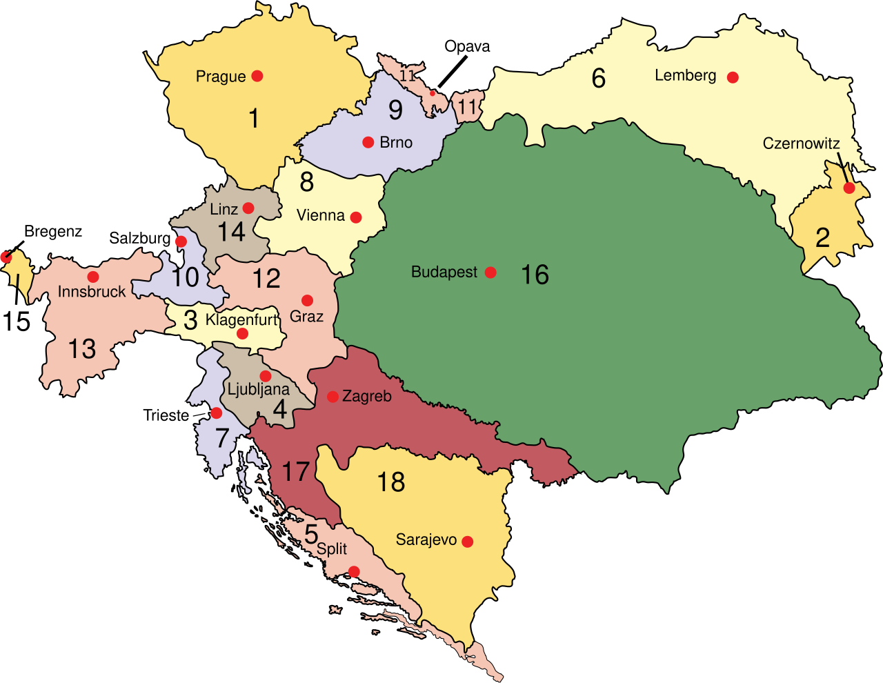
English: Austria
Deutsch: Österreich 1910
Esperanto: Aŭstrio 1910
Magyar: Ausztria
Latina: Austria:
Македонски: Австрија
Polski: Austro–Węgry
Svenska: Österrike-Ungern
Français : Autriche-Hongrie
Čeština: Rakousko-Uhersko
|
| 日期 | |
| 来源 | 自己的作品 (at English wikipedia) |
| 作者 | IMeowbot |
| 其他版本 |
[]
此文件衍生的作品:
|
| SVG开发 |


许可协议[编辑]
| |
本作品已被作者中文维基百科项目的IMeowbot释出到公有领域。这适用于全世界。 如果这样做不合法的话: |
文件历史
点击某个日期/时间查看对应时刻的文件。
| 日期/时间 | 缩略图 | 大小 | 用户 | 备注 | |
|---|---|---|---|---|---|
| 当前 | 2012年8月14日 (二) 12:54 | | 783 × 605(331 KB) | DIREKTOR(留言 | 贡献) | Softer shade of green for Hungary proper, desaturated red for the Kingdom of Croatia-Slavonia (Horvát-Szlavón Királyság). |
| 2011年2月3日 (四) 16:44 |  | 783 × 605(331 KB) | Vearthy(留言 | 贡献) | Kingdom of Hungary back in green, changed too strong orange to a bit lighter, pastel color | |
| 2010年4月16日 (五) 22:48 |  | 783 × 605(331 KB) | Vearthy(留言 | 贡献) | changed colours | |
| 2009年9月14日 (一) 22:49 |  | 783 × 605(331 KB) | Kirk979(留言 | 贡献) | english names of capitals | |
| 2009年9月14日 (一) 22:41 |  | 783 × 605(331 KB) | Kirk979(留言 | 贡献) | correctioons | |
| 2009年8月9日 (日) 21:00 |  | 783 × 605(315 KB) | Gugganij(留言 | 贡献) | Reverted to version as of 19:00, 24 July 2009, reason: the province "Küstenland" was blackened | |
| 2009年7月25日 (六) 22:13 |  | 800 × 640(274 KB) | Cäsium137~commonswiki(留言 | 贡献) | Valid IDs | |
| 2009年7月24日 (五) 23:41 |  | 800 × 640(274 KB) | Cäsium137~commonswiki(留言 | 贡献) | smooth | |
| 2009年7月24日 (五) 19:00 |  | 783 × 605(315 KB) | Hk kng(留言 | 贡献) | a bit of cleanup | |
| 2009年7月24日 (五) 18:32 |  | 783 × 605(319 KB) | Hk kng(留言 | 贡献) | testing whether using another font helps |
您不可以覆盖此文件。
文件用途
以下23个页面使用本文件:
- Atlas of Austria
- Atlas of Austria-Hungary
- Atlas of Bosnia and Herzegovina
- Atlas of Hungary
- Atlas of Poland
- Atlas of Slovakia
- Atlas of Slovenia
- Atlas of Székely Land
- Atlas of Ukraine
- Atlas of the Czech Republic
- Magyarország
- File:Austria-Hungary map-pl.svg
- File:Austria-Hungary map.svg
- File:Austria-Hungary map cs.svg
- File:Austria-Hungary map de.svg
- File:Austria-Hungary map hr.svg
- File:Austria-Hungary map hu.svg
- File:Austria-Hungary map mk.svg
- File:Austria-Hungary map new.svg
- File:Austria-Hungary map sr.svg
- File:Flag map of the Austro-Hungarian Empire (habsburg flag).svg
- Template:Other versions/Austria-Hungary map
- Category:Greater Hungary
.svg)
全域文件用途
以下其他wiki使用此文件:
- ar.wikipedia.org上的用途
- azb.wikipedia.org上的用途
- be-tarask.wikipedia.org上的用途
- be.wikipedia.org上的用途
- bs.wikipedia.org上的用途
- bxr.wikipedia.org上的用途
- ca.wikipedia.org上的用途
- cs.wikipedia.org上的用途
- da.wikipedia.org上的用途
- de.wikipedia.org上的用途
- de.wikibooks.org上的用途
- el.wikipedia.org上的用途
- en.wikipedia.org上的用途
- Hungary
- Carniola
- History of Styria
- Bay of Kotor
- Cisleithania
- Kingdom of Croatia-Slavonia
- Lands of the Crown of Saint Stephen
- History of Transylvania
- List of irredentist claims or disputes
- Wikipedia:WikiProject Former countries/Austria-Hungary task force
- Wikipedia:Reference desk/Archives/Humanities/2010 November 19
- List of World War I flying aces from Austria-Hungary
- User:Falcaorib
- en.wikibooks.org上的用途
- en.wikivoyage.org上的用途
- en.wiktionary.org上的用途
- eo.wikipedia.org上的用途
- et.wikipedia.org上的用途
查看本文件的更多全域用途。