File:BROOCH (FindID 973712).jpg

Original file (5,775 × 4,592 pixels, file size: 6.51 MB, MIME type: image/jpeg)
Captions
Captions
Summary
[edit].jpg&action=edit§ion=1)
| BROOCH | |||
|---|---|---|---|
| Photographer |
The Portable Antiquities Scheme, Andrew Williams, 2019-10-29 11:20:48 |
||
| Title |
BROOCH |
||
| Description |
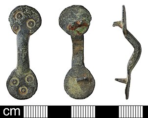
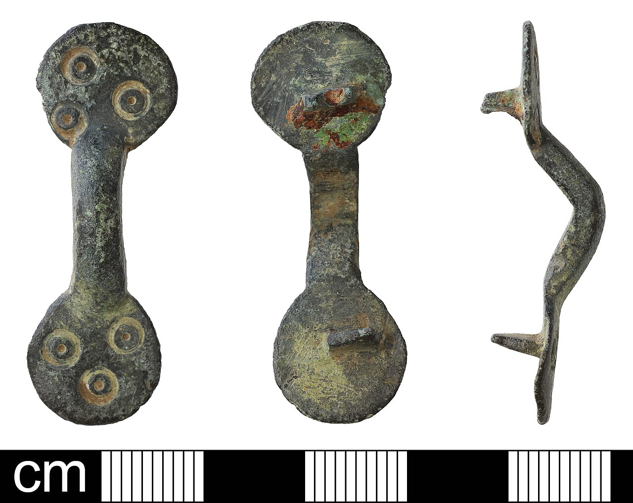
English: Middle to Late Anglo-Saxon copper alloy ansate brooch. Both terminals are sub-circular and are each decorated on the front with three punched ring-and-dots, in a triangular arrangement. The terminals are joined by an obtusely angled bow, which is approximately D-shaped in cross-section, but is in fact subtly chamfered so that it exhibits a central and two side arrises running longitudinally along the front. On the reverse of the brooch projecting off-centre from each terminal are the remnants of a pin lug. Each one is broken and worn at the level of the pin-hole. One of the lugs exhibits some iron staining on the surviving part of the pin perforation and around its base. Height: 39.6mm. Width: 8.0mm, 8.8mm (across terminals), 4.6mm (centre of bow). Thickness 1.3mm, 1.6mm (terminals), 5.9mm, 6.2mm (terminals and lugs). Weight: 4g. 700-1000AD Parallels on this database include NMS-D5341A and NMS-DC6A12 |
||
| Depicted place | (County of findspot) Norfolk | ||
| Date | between 700 and 1000 | ||
| Accession number |
FindIdentifier: 973712 |
||
| Credit line |
|
||
| Source |
https://finds.org.uk/database/ajax/download/id/1078581 Catalog: https://finds.org.uk/database/images/image/id/1078581/recordtype/artefacts archive copy at the Wayback Machine |
||
| Permission (Reusing this file) |
Attribution License version 2.0 (verified 3 December 2020) | ||
| Object location | | View this and other nearby images on: OpenStreetMap |
|---|
.jpg¶ms=052.645700_N_0000.860082_E_globe:Earth_class:object_type:object__&language=en)
Licensing
[edit].jpg&action=edit§ion=2)
- You are free:
- to share – to copy, distribute and transmit the work
- to remix – to adapt the work
- Under the following conditions:
- attribution – You must give appropriate credit, provide a link to the license, and indicate if changes were made. You may do so in any reasonable manner, but not in any way that suggests the licensor endorses you or your use.
File history
Click on a date/time to view the file as it appeared at that time.
| Date/Time | Thumbnail | Dimensions | User | Comment | |
|---|---|---|---|---|---|
| current | 23:16, 30 November 2020 | | 5,775 × 4,592 (6.51 MB) | Fæ (talk | contribs) | Portable Antiquities Scheme, NMS, FindID: 973712-1078581, early medieval, page 1343, batch count 23448 |
You cannot overwrite this file.
File usage on Commons
The following page uses this file:
.jpg)
.jpg&oldid=810877814)