File:Badain Jaran Desert (MODIS 2020-02-07).jpg

Original file (2,170 × 1,600 pixels, file size: 261 KB, MIME type: image/jpeg)
Captions
Captions
Summary[edit]
.jpg&action=edit§ion=1)
| Description |
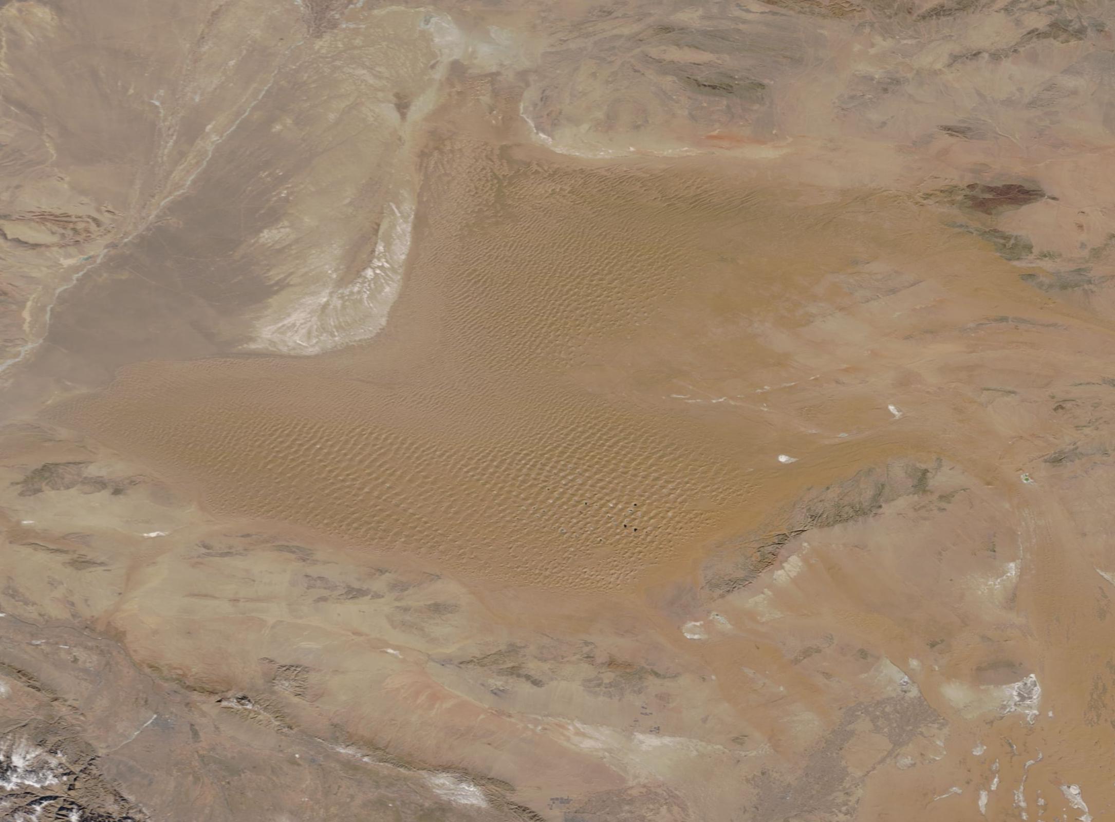
English: The Badain Jaran Desert stretches across about 19,300 square miles (50,000 sq. km) in western Inner Mongolia, China—an area roughly the size of Costa Rica. Unlike the lush greenness of the Central American tropics, the Bardain Jaran, with climatic zones ranging from temperate arid to extremely arid, hosts little vegetation, but lots of sand. And sand dunes. Massive, amazing sand dunes.
About half of the Badain Jaran gives rise to megadunes that tower between 660 to 980 feet (200 to 300 meters) tall. The tallest measures 1500 feet (460 meters), or about the same height as the 102-story Empire State Building of New York. The dunes are extremely complicated, and have been described by scientists as “complex reversing mega-dunes developed from compound barchanoid mega-dunes.” A barchan dune is crescent shaped, with “horns” pointing in the same direction as the wind blows. Barchan dunes tend to form in areas with steady wind direction and limited amounts of sand. Where more sand is available, and where wind direction is more variable, more complicated dunes can form. Reversing dunes often occur in areas where winds blow from opposite directions. The prevailing wind creates barchanoid dunes, and occasional winds from the opposite direction produce small dunes on the crests of the big dunes. Compound dunes are made from multiple dunes of the same type that overlap or overlie each other. Complex dunes are made from different types of dunes merging or overlapping. On February 2, 2020, the Moderate Resolution Imaging Spectroradiometer (MODIS) on board NASA’s Terra satellite acquired a true-color image of the Badain Jaran Desert. Long ripples of sand dunes mark much of the surface and are easily seen even at low resolution. Clicking on the higher-resolution image (250 m), the complexity of the dunes can be appreciated. This also allows a good look at the many dozens of lakes that dot the desert, primarily in the southeast. |
||
| Date | Taken on 2 February 2020 | ||
| Source |
Badain Jaran Desert (direct link)
|
||
| Author | MODIS Land Rapid Response Team, NASA GSFC |
| This media is a product of the Terra mission Credit and attribution belongs to the mission team, if not already specified in the "author" row |
Licensing[edit]
.jpg&action=edit§ion=2)
| This file is in the public domain in the United States because it was solely created by NASA. NASA copyright policy states that "NASA material is not protected by copyright unless noted". (See Template:PD-USGov, NASA copyright policy page or JPL Image Use Policy.) | ||
 |
Warnings:
|
File history
Click on a date/time to view the file as it appeared at that time.
| Date/Time | Thumbnail | Dimensions | User | Comment | |
|---|---|---|---|---|---|
| current | 03:20, 17 February 2024 | | 2,170 × 1,600 (261 KB) | OptimusPrimeBot (talk | contribs) | #Spacemedia - Upload of http://modis.gsfc.nasa.gov/gallery/images/image02072020_250m.jpg via Commons:Spacemedia |
You cannot overwrite this file.
File usage on Commons
There are no pages that use this file.
.jpg&oldid=852701473)