File:Bahamas (MODIS 2022-01-03).jpg

Original file (1,775 × 1,300 pixels, file size: 159 KB, MIME type: image/jpeg)
Captions
Captions
Summary
[edit].jpg&action=edit§ion=1)
| Description |
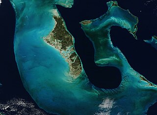
English: This stunning true-color image of a portion of the Bahamas was acquired by the Moderate Resolution Imaging Spectroradiometer (MODIS) on board NASA’s Terra satellite on December 16, 2021. The sparkling-clear sky allows a detailed view of Andros Island in the west, Eleuthera Island in the east, the bright jewel-tones of the Great Bahama Bank, and the deep blue of a deep underwater canyon that separates Andros Island from Eleuthera.
The largest island of the Bahamas, Andros measures about 100 miles (160 km) long and 45 miles (70 km) wide. The flat, forested island is actually a conglomeration of multiple islands which are strung together by a series of wetlands. To the west, the waters over the limestone-rich mound known as the Great Bahama Banks are extremely shallow—in some areas, only a food or two at most. Limestone is a sedimentary rock formed by the skeletal fragments of sea creatures, including corals and foraminifera, and this particular limestone platform has been accumulating since at least the Cretaceous Period. To the east of Andros, the sea floor abruptly plunges downward, reaching a depth of about 14,060 feet (4,285 miles). This deep water appears very dark, in brilliant contrast to the light color of the shallowest areas of the Great Bahamas Bank. The submarine trench appears to take the shape of a long tongue, giving this unique feature the name of “Tongue of the Ocean”. Colorful wave-shaped ripples sit at the southern edge of the Tongue. These are large underwater dunes that have been shaped by the action of the waves over time. |
||
| Date | Taken on 16 December 2021 | ||
| Source |
|
||
| Author | MODIS Land Rapid Response Team, NASA GSFC |
| This media is a product of the Terra mission Credit and attribution belongs to the mission team, if not already specified in the "author" row |
Licensing
[edit].jpg&action=edit§ion=2)
| This file is in the public domain in the United States because it was solely created by NASA. NASA copyright policy states that "NASA material is not protected by copyright unless noted". (See Template:PD-USGov, NASA copyright policy page or JPL Image Use Policy.) | ||
 |
Warnings:
|
File history
Click on a date/time to view the file as it appeared at that time.
| Date/Time | Thumbnail | Dimensions | User | Comment | |
|---|---|---|---|---|---|
| current | 22:23, 9 January 2024 | | 1,775 × 1,300 (159 KB) | OptimusPrimeBot (talk | contribs) | #Spacemedia - Upload of http://modis.gsfc.nasa.gov/gallery/images/image01032022_250m.jpg via Commons:Spacemedia |
You cannot overwrite this file.
File usage on Commons
There are no pages that use this file.
.jpg&oldid=840071618)