File:Bamberg Bahngleise Luftbild-20240728-RM-160035.jpg
From Wikimedia Commons, the free media repository
Jump to navigation
Jump to search
Size of this preview: 800 × 600 pixels. Other resolutions: 320 × 240 pixels | 640 × 480 pixels | 1,024 × 767 pixels | 1,280 × 959 pixels | 2,560 × 1,919 pixels | 3,992 × 2,992 pixels.
Original file (3,992 × 2,992 pixels, file size: 8.93 MB, MIME type: image/jpeg)
File information
Structured data
Captions
Summary
[edit]DescriptionBamberg Bahngleise Luftbild-20240728-RM-160035.jpg |
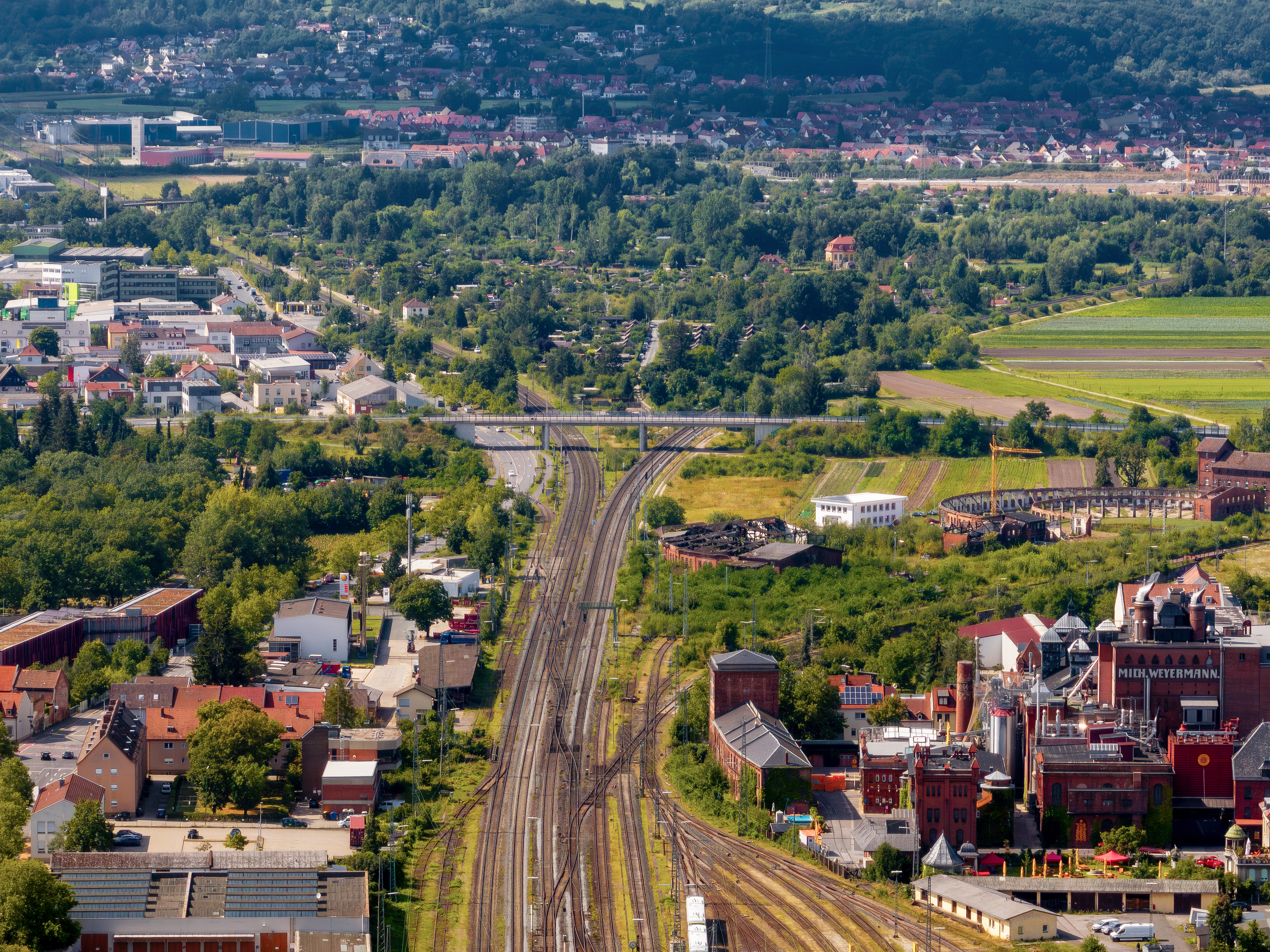
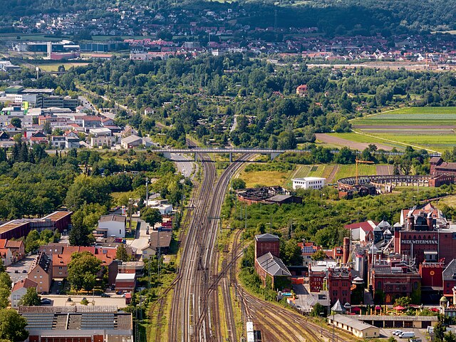
English: Tracks north of the railway station in Bamberg, aerial view.
Deutsch: Gleise nördlich des Bahnhofs in Bamberg, Luftaufnahme. |
||||||
Date | |||||||
Source | Own work | ||||||
Author | Reinhold Möller | ||||||
Permission (Reusing this file) |
|
Camera location | 49° 53′ 49.46″ N, 10° 54′ 14.81″ E | View this and other nearby images on: OpenStreetMap | 49.897072; 10.904113 |
---|
Licensing
[edit]This file is licensed under the Creative Commons Attribution-Share Alike 4.0 International license.
- You are free:
- to share – to copy, distribute and transmit the work
- to remix – to adapt the work
- Under the following conditions:
- attribution – You must give appropriate credit, provide a link to the license, and indicate if changes were made. You may do so in any reasonable manner, but not in any way that suggests the licensor endorses you or your use.
- share alike – If you remix, transform, or build upon the material, you must distribute your contributions under the same or compatible license as the original.
Annotations InfoField | This image is annotated: View the annotations at Commons |
803
663
928
578
3992
2992
Bahnstrecke Bamberg-Rottendorf
2270
1017
724
259
3992
2992
Bahnstrecke Bamberg-Hof
2530
683
299
204
3992
2992
Seehof Schlösschen
2131
1451
1766
374
3992
2992
ehemalige Lokschuppen
2221
1860
1742
1097
3992
2992
Malzfabrik Weyermann
File history
Click on a date/time to view the file as it appeared at that time.
Date/Time | Thumbnail | Dimensions | User | Comment | |
---|---|---|---|---|---|
current | 21:06, 6 August 2024 | 3,992 × 2,992 (8.93 MB) | Ermell (talk | contribs) | Uploaded with LrMediaWiki 1.8.0, LR 13.4 Win |
You cannot overwrite this file.
File usage on Commons
The following 2 pages use this file:
Metadata
This file contains additional information such as Exif metadata which may have been added by the digital camera, scanner, or software program used to create or digitize it. If the file has been modified from its original state, some details such as the timestamp may not fully reflect those of the original file. The timestamp is only as accurate as the clock in the camera, and it may be completely wrong.
Camera manufacturer | DJI |
---|---|
Camera model | FC4170 |
Copyright holder |
|
Exposure time | 1/320 sec (0.003125) |
F-number | f/4.4 |
ISO speed rating | 100 |
Date and time of data generation | 16:00, 28 July 2024 |
Lens focal length | 29.85 mm |
Latitude | 49° 53′ 49.46″ N |
Longitude | 10° 54′ 14.81″ E |
Altitude | 294.6 meters above sea level |
Online copyright statement | https://creativecommons.org/licenses/by-sa/4.0/ |
Usage terms |
|
City shown | Bamberg |
Horizontal resolution | 240 dpi |
Vertical resolution | 240 dpi |
Software used | Adobe Photoshop Lightroom Classic 13.4 (Windows) |
File change date and time | 23:06, 6 August 2024 |
Exposure Program | Manual |
Exif version | 2.31 |
Date and time of digitizing | 16:00, 28 July 2024 |
APEX shutter speed | 8.321928 |
APEX aperture | 4.275007 |
APEX exposure bias | −1 |
Maximum land aperture | 4.28 APEX (f/4.41) |
Subject distance | 0 meters |
Metering mode | Average |
Light source | Cloudy weather |
Flash | Flash did not fire |
Color space | sRGB |
Focal plane X resolution | 5,672.4682922363 |
Focal plane Y resolution | 5,672.4682922363 |
Focal plane resolution unit | 3 |
File source | Digital still camera |
Scene type | A directly photographed image |
Custom image processing | Normal process |
Exposure mode | Manual exposure |
White balance | Auto white balance |
Digital zoom ratio | 1 |
Focal length in 35 mm film | 161 mm |
Scene capture type | Standard |
Scene control | None |
Contrast | Normal |
Saturation | Normal |
Sharpness | Normal |
Receiver status | Measurement in progress |
Geodetic survey data used | WGS-84 |
GPS tag version | 0.0.3.2 |
Serial number of camera | 492QJ8E4AA05DL |
Lens used | 161.0 mm f/4.4 |
Date metadata was last modified | 01:06, 7 August 2024 |
Unique ID of original document | 735E983B0FB51C9677A327C7D0107004 |
Copyright status | Copyrighted |
Contact information |
|
Province or state shown | Bayern |
Country shown | Deutschland |
Code for country shown | DE |
IIM version | 4 |
Structured data
In dieser Datei abgebildete Objekte
depicts
28 July 2024
49°53'49.45801"N, 10°54'14.80799"E
0.003125 second
4.4
29.85 millimetre
100
image/jpeg
Hidden categories: