File:BarryArm-AK.jpg
Jump to navigation
Jump to search

Size of this preview: 800 × 560 pixels. Other resolutions: 320 × 224 pixels | 640 × 448 pixels | 1,024 × 717 pixels | 1,200 × 840 pixels.
Original file (1,200 × 840 pixels, file size: 243 KB, MIME type: image/jpeg)
Captions
Captions
Add a one-line explanation of what this file represents
Summary[edit]
| Description |
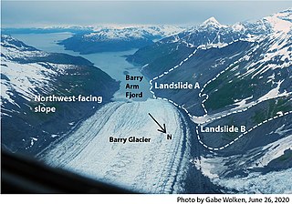
English: Annotated image showing landslide areas of Barry Arm Fjord, Alaska. Subaerial landslides at the head of Barry Arm Fjord in southern Alaska could generate tsunamis (if they rapidly failed into the Fjord) and are therefore a potential threat to people, marine interests, and infrastructure throughout the Prince William Sound region. |
| Date | |
| Source | U.S. Geological Survey |
| Author | Gabe Wolken |
Licensing[edit]
This image is in the public domain in the United States because it only contains materials that originally came from the United States Geological Survey, an agency of the United States Department of the Interior. For more information, see the official USGS copyright policy.
|
File history
Click on a date/time to view the file as it appeared at that time.
| Date/Time | Thumbnail | Dimensions | User | Comment | |
|---|---|---|---|---|---|
| current | 01:44, 24 September 2022 | | 1,200 × 840 (243 KB) | Dora the Axe-plorer (talk | contribs) | Uploaded a work by Gabe Wolken from [https://www.usgs.gov/media/images/annotated-photo-showing-landslide-areas-barry-arm-fjord-alaska U.S. Geological Survey] with UploadWizard |
You cannot overwrite this file.
File usage on Commons
The following page uses this file:
File usage on other wikis
The following other wikis use this file:
- Usage on en.wikipedia.org