File:Bathymetric map of the Spermonde Archipelago.jpg

Original file (680 × 647 pixels, file size: 372 KB, MIME type: image/jpeg)
Captions
Captions
Summary[edit]
| Description |
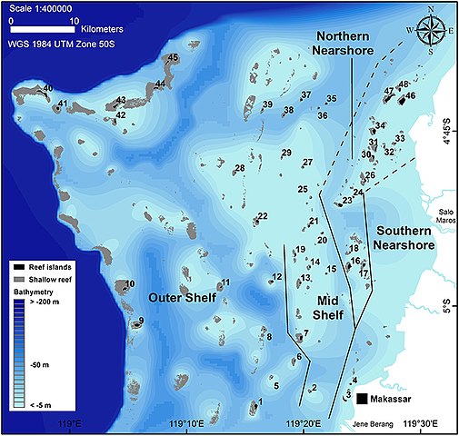
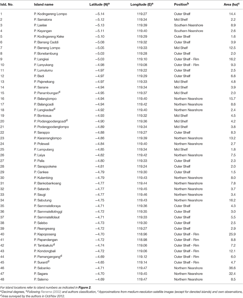
English: Bathymetric map of the Spermonde Archipelago showing all named islands and larger reef structures. At the shelf break, the water depth increases to about 200 m. Reef island numbers refer to islands names in Table 1. (and see below)
Isld. No., Island name, Area (ha) |
| Date | |
| Source | (2017). "Reef Island Evolution and Dynamics: Insights from the Indian and Pacific Oceans and Perspectives for the Spermonde Archipelago". Frontiers in Marine Science 4. DOI:10.3389/fmars.2017.00145. |
| Author | Paul S. Kench and Thomas Mann |
| Other versions |
|
.jpg)
Licensing[edit]
- You are free:
- to share – to copy, distribute and transmit the work
- to remix – to adapt the work
- Under the following conditions:
- attribution – You must give appropriate credit, provide a link to the license, and indicate if changes were made. You may do so in any reasonable manner, but not in any way that suggests the licensor endorses you or your use.
File history
Click on a date/time to view the file as it appeared at that time.
| Date/Time | Thumbnail | Dimensions | User | Comment | |
|---|---|---|---|---|---|
| current | 19:10, 5 December 2018 | | 680 × 647 (372 KB) | Animalparty (talk | contribs) | User created page with UploadWizard |
You cannot overwrite this file.
File usage on Commons
The following page uses this file:
File usage on other wikis
The following other wikis use this file:
- Usage on id.wikipedia.org
- Pulau Badi
- Pulau Salemo
- Taman Bumi Global UNESCO Maros-Pangkep
- Pulau Laiya (Liukang Tupabbiring Utara)
- Pulau Bangkobangkoang (Liukang Tupabbiring Utara)
- Pulau Pajenekang
- Pulau Sarappo Keke
- Pulau Sarappo Lompo
- Pulau Sanane
- Pulau Pala
- Pulau Cangke
- Pulau Lamputang
- Pulau Podang-Podang Caddi
- Pulau Podang-Podang Lompo
- Pulau Bontosua
- Pulau Langkadea
- Pulau Balang Caddi
- Pulau Balang Lompo
- Pulau Panambungan
- Pulau Karanrang
- Pulau Polewali
- Pulau Kulambing
- Pulau Satando
- Pulau Saugi
- Pulau Reang-Reang
- Pulau Samatellu Lompo
- Pulau Samatellu Pedda
- Pulau Samatellu Borong
- Pulau Salebbo
- Pulau Sagara
- Pulau Sabangko
- Pulau Saranti
- Pulau Pammanggangang
- Pulau Tambakulu
- Pulau Gondong Bali
- Pulau Kapoposang
- Pulau Pandangang
- Pulau Sabutung
- Story:Pulau Syiar Islam di Masa Lalu
- Kepulauan Kapoposang