File:Battle of Hanover map.png
Aller à la navigation
Aller à la recherche
Taille de cet aperçu : 691 × 600 pixels. Autres résolutions : 277 × 240 pixels | 553 × 480 pixels | 885 × 768 pixels | 1 180 × 1 024 pixels | 1 785 × 1 549 pixels.
Fichier d’origine (1 785 × 1 549 pixels, taille du fichier : 1,39 Mio, type MIME : image/png)
Légendes
Légendes
Ajoutez en une ligne la description de ce que représente ce fichier
Description
[modifier]
| Description |
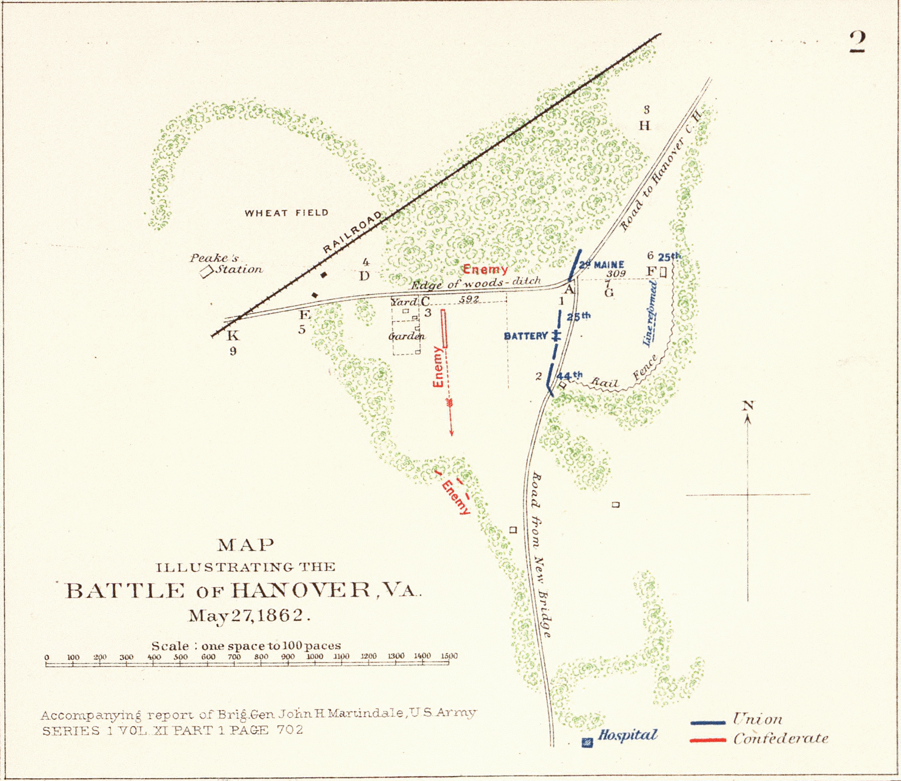
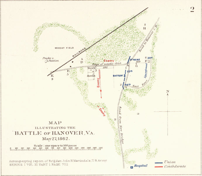
English: Rough sketch of reconnaissance, May 24th, 1862 (by) R. H. Rush, Col. Lancers. Extracted map illustrating the Battle of Hanover, Va., May 27, 1862. Full version available at the David Rumsey Historical Map Collection: Images from U.S. Civil War. Accompanying report of Brig. Gen. John H. Martindale ... Engagement near Hanover Court-House, Va., May 27, 1862. Accompanying report of Col. S.W. Stryker ... Reconnaissance made on the afternoon of May the 23d, 1862 (by) Alexander Doull ... Map of march from Mount Airey to Old Church, Va., May 23rd 1862 ... accompanying report of Col. R.O. Tyler ... Skirmish between two rebel batteries and Battery B, 1st Md. Arty., June 5th, 1862 at New Bridge, Va. Accompanying report of Captain A. Snow ... Battle of Mechanicsville, Va., June 26 and 27, 1862. Accompanying report of Brig. Gen. T. Seymour ... Sketch of the Battle of New Market, Va., June 30, 1862 ... Map to accompany the report of Brig. Gen. J.E.B. Stuart ... commanding Pamunkey Expedition to the enemy's rear, June 13, 14 and 15, 1862 ... Malvern Hill, Va., Morrell's Division, July 1st, 1862. Engagement near Hanover Court-House, Va., May 27, 1862. Accompanying report of Brig. Gen. D. Butterfield ... Topography of the battle-field of Cross Keys, Va. by Lieut. Col. John Pilsen ... Accompanying report of Maj. Gen. J.C. Fremont ... Map of route and positions, First Corps, Army of Virginia, Major General Sigel, commanding from July 7th to Sept. 10th 1862 (by) Franz Kappner, Maj. and Chf. Engr. Julius Bien & Co., Lith., N.Y. (1891-1895) Author: United States. War Department; Date: 1895 |
| Date | |
| Source | http://www.davidrumsey.com/maps1100149-26853.html |
| Auteur | R. H. Rush, Col. Lancers. |
Conditions d’utilisation
[modifier]
Cette image est une œuvre d'un soldat ou d'un employé de l'U.S. Army, réalisée dans le cadre de ses activités professionnelles. En tant qu'œuvre du gouvernement fédéral des États-Unis d'Amérique, cette image fait partie du domaine public.
|
 |
Journal des téléversements d’origine
[modifier]
La page de description originale était ici. Tous les noms d'utilisateur qui suivent se rapportent à en.wikipedia.
| Date et heure | Dimensions | Utilisateur | Commentaire |
|---|---|---|---|
| 2005-01-23 05:39 | 1785×1549× (1453578 bytes) | Brian0918 | Rough sketch of reconnaissance, May 24th, 1862 (by) R.H. Rush, Col. Lancers. Map illustrating the Battle of Hanover, Va., May 27, 1862. Accompanying report of Brig. Gen. John H. Martindale ... Engagement near Hanover Court-House, Va., May 27, 1862. Accomp |
Historique du fichier
Cliquer sur une date et heure pour voir le fichier tel qu'il était à ce moment-là.
| Date et heure | Vignette | Dimensions | Utilisateur | Commentaire | |
|---|---|---|---|---|---|
| actuel | 4 décembre 2015 à 22:02 | | 1 785 × 1 549 (1,39 Mio) | Tikky19 (d | contributions) | Transferred from en.wikipedia |
Vous ne pouvez pas remplacer ce fichier.
Utilisations locales du fichier
Aucune page n’utilise ce fichier.
Utilisations du fichier sur d’autres wikis
Les autres wikis suivants utilisent ce fichier :
- Utilisation sur en.wikipedia.org
- Utilisation sur fr.wikipedia.org