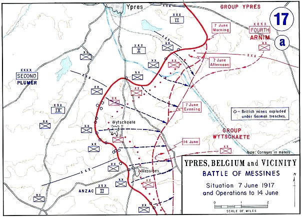
File:Battle of Messines - Map.jpg
Battle_of_Messines_-_Map.jpg (604 × 434 kuvapistettä, 115 KiB, MIME-tyyppi: image/jpeg)
Kuvatekstit
Kuvatekstit
Description:
Source: West Point Department of History archive copy at the Wayback Machine
Background information: In 1938 the predecessors of what is today The Department of History at the United States Military Academy began developing a series of campaign atlases to aid in teaching cadets a course entitled, "History of the Military Art." Since then, the Department has produced over six atlases and more than one thousand maps, encompassing not only America’s wars but global conflicts as well.
In keeping abreast with today's technology, the Department of History is providing these maps on the internet as part of the department's outreach program. The maps were created by the United States Military Academy’s Department of History and are the digital versions from the atlases printed by the United States Defense Printing Agency. We gratefully acknowledge the accomplishments of the department's former cartographer, Mr. Edward J. Krasnoborski, along with the works of our present cartographer, Mr. Frank Martini.
Please be aware that these maps are large in file size and may require substantial download times.
Tämän kuvan on ottanut tai tehnyt Yhdysvaltain liittovaltion armeijan sotilas tai työntekijä virallisia velvollisuuksiansa suorittaessaan. Yhdysvaltain liittovaltion viranomaisten työntekijöiden tekemät teokset eivät saa tekijänoikeuden suojaa Yhdysvaltain tekijänoikeuslain 105 § mukaisesti.
|
 |
Tiedoston historia
Päiväystä napsauttamalla näet, millainen tiedosto oli kyseisellä hetkellä.
| Päiväys | Pienoiskuva | Koko | Käyttäjä | Kommentti | |
|---|---|---|---|---|---|
| nykyinen | 30. heinäkuuta 2011 kello 16.59 | | 604 × 434 (115 KiB) | Hohum (keskustelu | muokkaukset) | Cleanup |
| 16. kesäkuuta 2005 kello 15.26 |  | 604 × 434 (94 KiB) | W.wolny (keskustelu | muokkaukset) |
Et voi tallentaa uutta tiedostoa tämän tilalle.
Tiedoston käyttö
Seuraava sivu käyttää tätä tiedostoa:
Tiedoston järjestelmänlaajuinen käyttö
Seuraavat muut wikit käyttävät tätä tiedostoa:
- Käyttö sivustolla ar.wikipedia.org
- Käyttö sivustolla be.wikipedia.org
- Käyttö sivustolla ca.wikipedia.org
- Käyttö sivustolla de.wikipedia.org
- Käyttö sivustolla el.wikipedia.org
- Käyttö sivustolla en.wikipedia.org
- Battle of Messines (1917)
- Wikipedia:WikiProject Military history/News/February 2013/Articles
- Mines in the Battle of Messines (1917)
- 175th Tunnelling Company
- 171st Tunnelling Company
- 250th Tunnelling Company
- 3rd Canadian Tunnelling Company
- 1st Canadian Tunnelling Company
- 1st Australian Tunnelling Company
- Capture of Wytschaete
- File talk:Battle of Messines - Map.jpg
- Käyttö sivustolla es.wikipedia.org
- Käyttö sivustolla fi.wikipedia.org
- Käyttö sivustolla fr.wikipedia.org
- Käyttö sivustolla ga.wikipedia.org
- Käyttö sivustolla he.wikipedia.org
- Käyttö sivustolla id.wikipedia.org
- Käyttö sivustolla it.wikipedia.org
- Käyttö sivustolla nl.wikipedia.org
- Käyttö sivustolla nn.wikipedia.org
- Käyttö sivustolla no.wikipedia.org
- Käyttö sivustolla pl.wikipedia.org
- Käyttö sivustolla pt.wikipedia.org
- Käyttö sivustolla ru.wikipedia.org
- Käyttö sivustolla simple.wikipedia.org
- Käyttö sivustolla sv.wikipedia.org
- Käyttö sivustolla uk.wikipedia.org
- Käyttö sivustolla ur.wikipedia.org
- Käyttö sivustolla www.wikidata.org