File:Batz-ChickasawVillages1736 SEM236C F329014.jpg
Jump to navigation
Jump to search
Size of this preview: 410 × 600 pixels. Other resolutions: 164 × 240 pixels | 328 × 480 pixels | 525 × 768 pixels | 700 × 1,024 pixels | 1,399 × 2,048 pixels | 2,679 × 3,920 pixels.
Original file (2,679 × 3,920 pixels, file size: 1.09 MB, MIME type: image/jpeg)
Captions
Captions
Add a one-line explanation of what this file represents
Summary
[edit]
| Description |
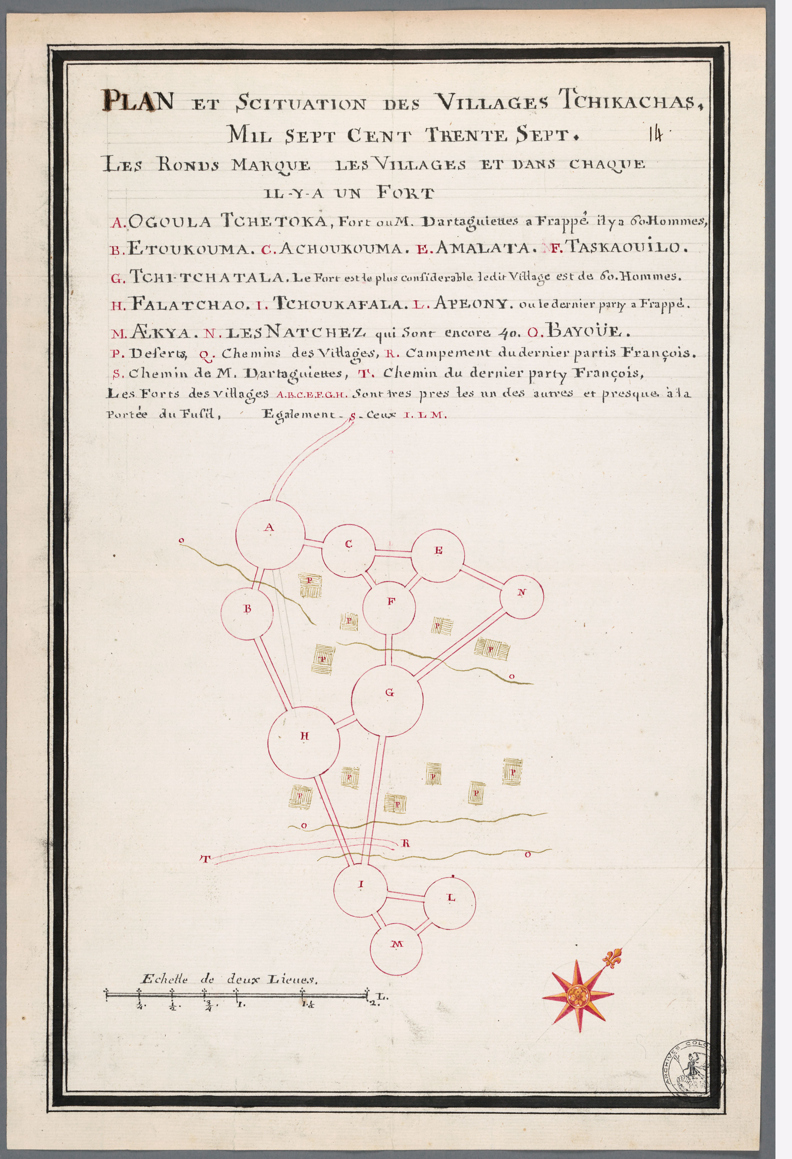
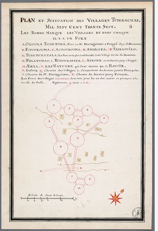
English: Plan et Scituation des Villages Tchikachas Plan and Situation of the Chickasaw Villages, Alexandre de Batz, 1737. French copy of a map made by a visitor to the Chickasaw. A indicates 'Ogoula Tchetoka, fort where M. d'Artaguette attacked', 4 mi SSE of present day Pontotoc, Mississippi on 25 March, 1736. M indicates Ackia, at present day Tupelo, Mississippi, Bienville's point of attack on May 26, 1736. |
||||||||||||||||||||||
| Date | |||||||||||||||||||||||
| Source |
Free use and distribution according to the archival description. http://bd.archivescanadafrance.org/acf/view.xsp?qid=sdx_q0&p=1&b=acfdb&id=FRCAOM_F3290_14 This map is described by Gregory A. Waselkov in Indian Maps of the Southeast, which is published in Powhatan's Mantle: Indians in the Colonial Southeast, ISBN 08032986 pp. 483-486 |
||||||||||||||||||||||
| Author |
|
||||||||||||||||||||||
| Permission (Reusing this file) |
This image is in the public domain due to its age. | ||||||||||||||||||||||
Licensing
[edit]
|
This work is in the public domain in its country of origin and other countries and areas where the copyright term is the author's life plus 100 years or fewer. | |
| This file has been identified as being free of known restrictions under copyright law, including all related and neighboring rights. | |
File history
Click on a date/time to view the file as it appeared at that time.
| Date/Time | Thumbnail | Dimensions | User | Comment | |
|---|---|---|---|---|---|
| current | 10:04, 16 May 2010 | | 2,679 × 3,920 (1.09 MB) | File Upload Bot (Magnus Manske) (talk | contribs) | {{BotMoveToCommons|en.wikipedia|year={{subst:CURRENTYEAR}}|month={{subst:CURRENTMONTHNAME}}|day={{subst:CURRENTDAY}}}} {{Information |Description={{en|''Plan et Scituation des Villages Tchikachas'' Plan and Situation of the Chickasaw Villages, Alexandre |
You cannot overwrite this file.
File usage on Commons
There are no pages that use this file.
File usage on other wikis
The following other wikis use this file:
- Usage on ca.wikipedia.org
- Usage on en.wikipedia.org
- Usage on fr.wikipedia.org
- Usage on incubator.wikimedia.org
- Usage on ru.wikipedia.org