File:Bay of Bengal map de.svg
Zur Navigation springen
Zur Suche springen

Gröössi vor PNG-Vorschou vor SVG-Datei: 605 × 599 Pixel. Wyteri Ufflösige: 242 × 240 Pixel | 485 × 480 Pixel | 775 × 768 Pixel | 1.034 × 1.024 Pixel | 2.068 × 2.048 Pixel | 1.662 × 1.646 Pixel.
Originaldatei (SVG-Datei, Basisgrößi: 1.662 × 1.646 Pixel, Dateigrößi: 508 KB)
Bildtexte
Kurzbeschreibungen
Ergänze eine einzeilige Erklärung, was diese Datei darstellt.
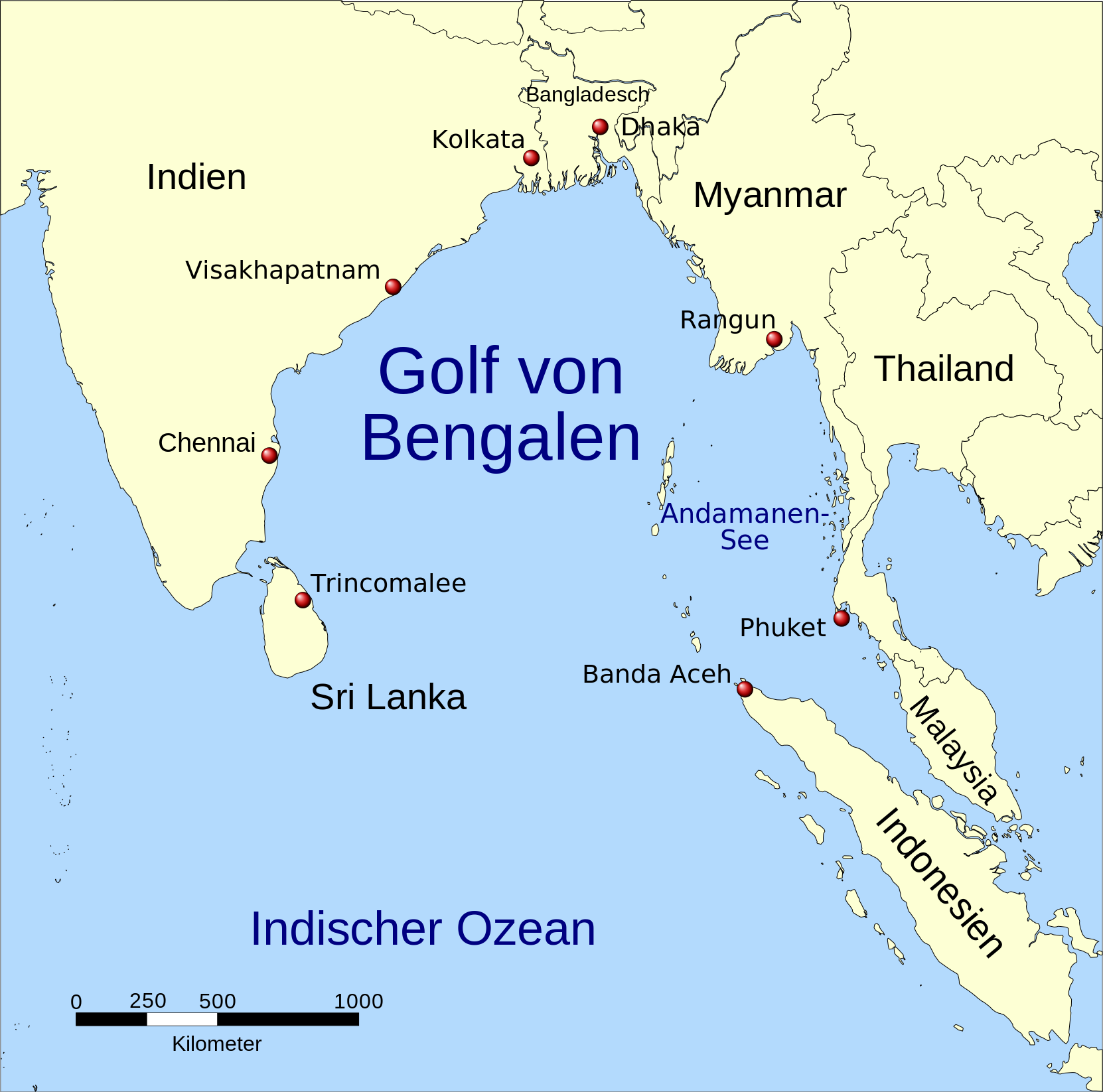
| Bschryybig | A map showing the location of the Bay of Bengal and the Andaman Sea in southeast Asia. |
| Datum | (UTC) |
| Quälle | |
| Urheber |
|
| Anderi Versione |
|


| Dieses Bild wurde digital nachbearbeitet. Folgende Änderungen wurden vorgenommen: Vector version, Tamil. Das Originalbild kann hier eingesehen werden: Red pog.svg:
|

|
Diese Karte wurde in der Kartenwerkstatt erstellt oder verbessert. Auch du kannst dort Karten vorschlagen, die zu erstellen, verändern oder übersetzen sind.
|

|
This SVG file contains embedded text that can be translated into your language, using any capable SVG editor, text editor or the SVG Translate tool. For more information see: About translating SVG files. |

|
Des Dokumänt derf kopiert, verbreitet un/oder bearbeitet wäre unter dr Bedingige vu dr GNU-Lizänz fir freji Dokumäntation, Version 1.2 oder ere spetere Version, vereffetligt dur Free Software Foundation. S het keini uuveränderlige Abschnitt, kei vordere Umschlagstext un kei hindere Umschlagstext. E Kopii vu dr Lizänz isch verfiegbar im Abschnitt GNU-Lizänz fir freji Dokumäntation. |
| Die Datei isch lizänziert unter dr Creative-Commons-Lizenz Namensnännig – Wytergab unter glyche Bedingige 3.0 nit portiert. | ||
| ||
| Die Lizänzmarkierig isch wäg em GFDL-Lizänzupdate zuegfiegt wore. |
Orginal Logbuech vu uffegladene Datei[ändere]
This image is a derivative work of the following images:
- Image:Bay_of_Bengal_map.png licensed with GFDL
- 2006-02-06T14:47:19Z NormanEinstein 1000x1019 (349850 Bytes) Corrected typo.
- 2005-09-15T20:33:04Z NormanEinstein 800x814 (268248 Bytes) A map showing the location of the Bay of Bengal and the Andaman Sea in southeast Asia. Created by NormanEinstein, September 15, 2005. {{GFDL-self}} [[Category:Maps of Seas]]
- Image:Asia98.svg licensed with PD-USGov
- 2007-10-23T04:49:13Z Brianski 8000x4390 (9380412 Bytes) == NOTE! == This file is very large. It takes >2GB of memory just to open it in inkscape. == Summary == {{Information |Description=Map of Asia as of 1998, with first level administrative units. See also [[:Image:World98.svg]
- Image:Red_pog.svg licensed with PD-self
- 2006-11-23T04:33:54Z Andux 64x64 (607 Bytes) Reverted to earlier revision
- 2006-11-19T18:20:08Z Minestrone 10x10 (16830 Bytes) '
- 2006-11-19T18:18:25Z Minestrone 10x10 (16830 Bytes) radial gradient added to fill to give 3d effect (see: [[:en:Image:Locator Dot.svg]])
- 2006-06-26T09:07:26Z Andux 64x64 (607 Bytes) a little brighter
- 2006-06-26T08:35:17Z Andux 64x64 (607 Bytes) Shiny red button/marker widget. [[Category:Icons]][[Category:Buttons]]
|Permission= |other_versions= }}
| Dieses Bild wurde digital nachbearbeitet. Folgende Änderungen wurden vorgenommen: translation. Das Originalbild kann hier eingesehen werden: Bay of Bengal map ta.svg:
|
Ich haa s Urheberrächt an däm Wärch un vereffetlig s dodermit unter däre Lizänz:
|
|
Des Dokumänt derf kopiert, verbreitet un/oder bearbeitet wäre unter dr Bedingige vu dr GNU-Lizänz fir freji Dokumäntation, Version 1.2 oder ere spetere Version, vereffetligt dur Free Software Foundation. S het keini uuveränderlige Abschnitt, kei vordere Umschlagstext un kei hindere Umschlagstext. E Kopii vu dr Lizänz isch verfiegbar im Abschnitt GNU-Lizänz fir freji Dokumäntation. |
Orginal Logbuech vu uffegladene Datei[ändere]
This image is a derivative work of the following images:
- File:Bay_of_Bengal_map_ta.svg licensed with GFDL
- 2008-09-22T08:14:10Z Trengarasu 1662x1646 (523092 Bytes) {{Information |Description=A map showing the location of the Bay of Bengal and the Andaman Sea in southeast Asia. |Source=*[[:Image:Bay_of_Bengal_map.png|]] *[[:Image:Asia98.svg|]] *[[:Image:Red_pog.svg|]] |Date=2008-09-22 08
Hochgeladen mit derivativeFX
Dateiversione
Klick uf e Zytpunkt zu aazeige, wie s dert usgsäh het.
| Version vom | Vorschaubild | Mäß | Benutzer | Kommentar | |
|---|---|---|---|---|---|
| aktuell | 10:03, 3. Jan. 2016 | | 1.662 × 1.646 (508 KB) | Furfur (Diskussion | Byträg) | moved Dhaka and Kolkata more to the North |
| 19:27, 21. Feb. 2009 |  | 1.662 × 1.646 (515 KB) | Bamse (Diskussion | Byträg) | Indonesien | |
| 17:58, 21. Feb. 2009 |  | 1.662 × 1.646 (515 KB) | Bamse (Diskussion | Byträg) | {{Information |Description=A map showing the location of the Bay of Bengal and the Andaman Sea in southeast Asia. |Source=*File:Bay_of_Bengal_map_ta.svg |Date=2009-02-21 17:56 (UTC) |Author=*File:Bay_of_Bengal_map_ta.svg: *derivative work: [[U |
Du chasch die Datei nit iberschryybe.
Verwändig vu dr Datei
Die 4 Syte bruuche die Datei:
Wältwyti Dateinutzig
Die andere Wikis bruche die Datei:
- Gebruch uf als.wikipedia.org
- Gebruch uf de.wikipedia.org
- Gebruch uf de.wiktionary.org
- Gebruch uf frr.wikipedia.org
- Gebruch uf nl.wikipedia.org
- Gebruch uf pl.wiktionary.org
- Gebruch uf uk.wikipedia.org