File:Beach within Botanical Garden, Entebbe, Uganda.jpg
Jump to navigation
Jump to search

Size of this preview: 800 × 450 pixels. Other resolutions: 320 × 180 pixels | 640 × 360 pixels | 1,024 × 576 pixels | 1,280 × 720 pixels | 2,560 × 1,440 pixels.
Original file (2,560 × 1,440 pixels, file size: 1.27 MB, MIME type: image/jpeg)
Captions
Captions
Add a one-line explanation of what this file represents
Summary
[edit]
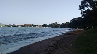
| Description | People swimming on shores of Lake Victoria within Botanical Garden in Entebbe, Uganda |
| Date | 11 June 2017 (according to Exif data) |
| Source | Own work |
| Author | Rcdwealth |
| Camera location | | View this and other nearby images on: OpenStreetMap |
|---|
Licensing
[edit]
I, the copyright holder of this work, hereby publish it under the following license:
This file is licensed under the Creative Commons Attribution 4.0 International license.
- You are free:
- to share – to copy, distribute and transmit the work
- to remix – to adapt the work
- Under the following conditions:
- attribution – You must give appropriate credit, provide a link to the license, and indicate if changes were made. You may do so in any reasonable manner, but not in any way that suggests the licensor endorses you or your use.
| This file was uploaded via Mobile Android App (Commons mobile app) 2.4.1. |
File history
Click on a date/time to view the file as it appeared at that time.
| Date/Time | Thumbnail | Dimensions | User | Comment | |
|---|---|---|---|---|---|
| current | 14:39, 11 June 2017 | | 2,560 × 1,440 (1.27 MB) | Rcdwealth (talk | contribs) | Uploaded using Android Commons app |
You cannot overwrite this file.
File usage on Commons
The following page uses this file: