File:Bedford UK locator map.svg
Aller à la navigation
Aller à la recherche

Taille de cet aperçu PNG pour ce fichier SVG : 530 × 599 pixels. Autres résolutions : 212 × 240 pixels | 425 × 480 pixels | 679 × 768 pixels | 906 × 1 024 pixels | 1 812 × 2 048 pixels | 1 120 × 1 266 pixels.
Fichier d’origine (Fichier SVG, nominalement de 1 120 × 1 266 pixels, taille : 675 kio)
Légendes
Légendes
Ajoutez en une ligne la description de ce que représente ce fichier
| Description |
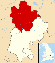
Map of Bedfordshire, UK with Bedford highlighted. Equirectangular map projection on WGS 84 datum, with N/S stretched 160% |
| Date | |
| Source |
|
| Auteur | Nilfanion, created using Ordnance Survey data |
| Autorisation (Réutilisation de ce fichier) |
Ce fichier est disponible selon les termes de la licence Creative Commons Attribution – Partage dans les Mêmes Conditions 3.0 (non transposée). Attribution: Contains Ordnance Survey data © Crown copyright and database right
|
Historique du fichier
Cliquer sur une date et heure pour voir le fichier tel qu'il était à ce moment-là.
| Date et heure | Vignette | Dimensions | Utilisateur | Commentaire | |
|---|---|---|---|---|---|
| actuel | 3 août 2011 à 22:42 | | 1 120 × 1 266 (675 kio) | Nilfanion (d | contributions) | {{Information |Description=Map of Bedfordshire, UK with Bedford highlighted. Equirectangular map projection on WGS 84 datum, with N/S stretched 160% |Source=Ordnance Survey [https://www.ord |
Vous ne pouvez pas remplacer ce fichier.
Utilisations locales du fichier
La page suivante utilise ce fichier :
Utilisations du fichier sur d’autres wikis
Les autres wikis suivants utilisent ce fichier :
- Utilisation sur cy.wikipedia.org
- Utilisation sur da.wikipedia.org
- Utilisation sur en.wikipedia.org
- Utilisation sur es.wikipedia.org
- Utilisation sur fa.wikipedia.org
- Utilisation sur fi.wikipedia.org
- Utilisation sur frr.wikipedia.org
- Utilisation sur fr.wikipedia.org
- Bedford (Royaume-Uni)
- Cardington (Bedfordshire)
- Kempston
- Wixams
- Bedford (district)
- Liste des paroisses civiles du Bedfordshire
- Carlton (Bedfordshire)
- Biddenham
- Modèle:Palette Bedford
- Oakley (Bedfordshire)
- Bletsoe
- Bolnhurst and Keysoe
- Colmworth
- Cople
- Wymington
- Staploe
- Stevington
- Stewartby
- Wootton (Bedfordshire)
- Willington (Bedfordshire)
- Wilden (Bedfordshire)
- Thurleigh
- Stagsden
- Sharnbrook
- Renhold
- Ravensden
- Podington
- Pertenhall
- Pavenham
- Odell (Bedfordshire)
- Milton Ernest
- Little Barford
- Little Staughton
- Harrold (Bedfordshire)
- Great Denham
- Great Barford
- Elstow
- Kempston Rural
- Knotting and Souldrop
- Dean and Shelton
- Wyboston, Chawston and Colesden
- Felmersham
- Chellington
Voir davantage sur l’utilisation globale de ce fichier.