File:Bedfordshire UK location map.svg
Spring til navigation
Spring til søgning

Size of this PNG preview of this SVG file: 530 × 599 pixels. Andre opløsninger: 212 × 240 pixels | 425 × 480 pixels | 679 × 768 pixels | 906 × 1.024 pixels | 1.812 × 2.048 pixels | 1.120 × 1.266 pixels.
Oprindelig fil (SVG fil, basisstørrelse 1.120 × 1.266 pixels, filstørrelse: 1,34 MB)
Captions
Captions
Tilføj en kort forklaring på en enkelt linje om hvad filen viser
| Beskrivelse |
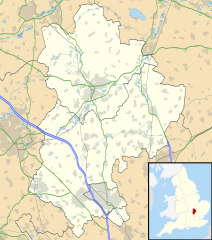
Map of Bedfordshire, UK with the following information shown:
Equirectangular map projection on WGS 84 datum, with N/S stretched 160% Geographic limits:
|
| Dato | |
| Kilde |
|
| Forfatter | Nilfanion, created using Ordnance Survey data |
| Tilladelse (Genbrug af denne fil) |
Denne fil er udgivet under Creative Commons Kreditering-Del på samme vilkår 3.0 Ikke-porteret-licensen. Kreditering: Contains Ordnance Survey data © Crown copyright and database right
|
| Andre versioner | File:Bedfordshire UK district map (blank).svg - Blank map with administrative borders only. |
.svg)
Filhistorik
Klik på en dato/tid for at se filen som den så ud på det tidspunkt.
| Dato/tid | Miniaturebillede | Dimensioner | Bruger | Kommentar | |
|---|---|---|---|---|---|
| nuværende | 26. sep. 2010, 17:56 | | 1.120 × 1.266 (1,34 MB) | Nilfanion (diskussion | bidrag) | Tweak m-ways .. again.. |
| 6. sep. 2010, 23:56 |  | 1.120 × 1.266 (1,34 MB) | Nilfanion (diskussion | bidrag) | Tweaking urban areas, road colours and boundary lines | |
| 4. sep. 2010, 20:36 |  | 1.120 × 1.266 (1,29 MB) | Nilfanion (diskussion | bidrag) | {{Information |Description=Map of Bedfordshire, UK with the following information shown: *Administrative borders *Coastline, lakes and rivers *Motorways, primary routes and A-roads *Urban areas Equirectangular map projection on WGS 84 |
Du kan ikke overskrive denne fil.
Filanvendelse
Den følgende side bruger denne fil:
Global filanvendelse
Følgende andre wikier anvender denne fil:
- Anvendelser på af.wikipedia.org
- Anvendelser på ar.wikipedia.org
- Anvendelser på bg.wikipedia.org
- Anvendelser på bn.wikipedia.org
- Anvendelser på ceb.wikipedia.org
- Anvendelser på en.wikipedia.org
- Bedford
- Bushmead Priory
- Beeston, Bedfordshire
- Luton Airport
- Flitwick
- Kempston
- Biggleswade
- Sandy, Bedfordshire
- Little Barford
- Ampthill
- Leighton Buzzard
- Woburn, Bedfordshire
- Eaton Bray
- Linslade
- Southcote, Bedfordshire
- Woburn Sands
- Studham
- Potton
- Old Warden
- Billington, Bedfordshire
- Eversholt
- RAF Chicksands
- RAF Henlow
- Bromham, Bedfordshire
- Everton, Bedfordshire
- List of places in Bedfordshire
- Stagsden
- Clapham, Bedfordshire
- Pertenhall
- RAE Bedford
- Hockliffe
- Houghton House
- Luton Hoo
- Campton, Bedfordshire
- Haynes, Bedfordshire
- Civil parishes in Bedfordshire
- Wootton, Bedfordshire
- Cranfield
- Hundred of Biggleswade
- Cockayne Hatley
- Odell, Bedfordshire
- Wrest Park
- Cardington, Bedfordshire
Vis flere globale anvendelser af denne fil.