File:Bergtocht van Guarda via Ardez en Ftan naar Scuol. 20-09-2019. (actm.) 27.jpg
Jump to navigation
Jump to search

Size of this preview: 800 × 500 pixels. Other resolutions: 320 × 200 pixels | 640 × 400 pixels | 1,024 × 640 pixels | 1,280 × 800 pixels | 2,560 × 1,600 pixels | 4,838 × 3,024 pixels.
Original file (4,838 × 3,024 pixels, file size: 12.33 MB, MIME type: image/jpeg)
Captions
Captions
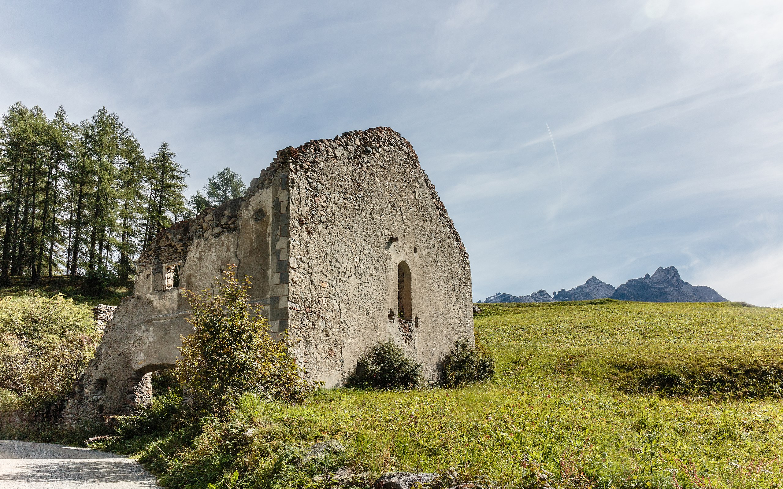
Ruina chanoua at Ardez.
Summary[edit]
| Description |
Nederlands: Bergtocht van Guarda (Zwitserland) via Ardez en Ftan naar Scuol Ruina chanoua bij Ardez.
Українська: Гірський тур з Гуарди, через Ардез і Фтан до Шкуоль, Руїна Чануа в Ардезі, кантон Граубюнден, Швейцарія. |
| Date | |
| Source | Own work |
| Author | Agnes Monkelbaan |
| Other versions |
|
_25.jpg)
_26.jpg)
_24.jpg)
_28.jpg)
_29.jpg)
_32.jpg)
_33.jpg)
| Camera location | | View this and other nearby images on: OpenStreetMap |
|---|
Assessment[edit]
|
This image was selected as picture of the day on Wikimedia Commons for 14 March 2023. It was captioned as follows: Other languages:
Čeština: Horská cesta ze švýcarské obce Guarda přes Ardez a Ftan do města Scuol kolem rozpadající se budovy Ruina Chanoua Ardez. Deutsch: Ruine des Passantenhauses und Postgebäudes („fiskalische Taberne“) Chanoua in Ardez im Kanton Graubünden, Schweiz. Français : Ruine dans la commune de Guarda (Suisse). Magyar: Hegyi túra Guardából Ardezen és Ftanon keresztül a Scuol melletti Ruina chanouahoz (Svájc) Nederlands: Ruïne langs de bergroute van Guarda via Ardez en Ftan naar Scuol in het Zwitserse kanton Graubünden Slovenščina: Ruševine obpotne hiše in poštne stavbe (»fiskalische Taberne«) Chanoua v Guardi (Švica) Македонски: Урнатина кај Ардец, Швајцарија. Українська: Гірський тур з Гуарди, через Ардез і Фтан до Шкуоль, Руїна Чануа в Ардезі, кантон Граубюнден, Швейцарія. |
This image has been assessed using the Quality image guidelines and is considered a Quality image.
|
Mountain tour of Guarda, Switzerland via Ardez and Ftan to Scuol.
Wandeltochten vanuit Val Sinestra (1474 meter), in het Unterengadin in Graubünden, Zwitserland
Walking tours from Val Sinestra (1474 meters), in Unterengadin in Graubünden, Switzerland
Licensing[edit]
I, the copyright holder of this work, hereby publish it under the following license:
This file is licensed under the Creative Commons Attribution-Share Alike 4.0 International license.
- You are free:
- to share – to copy, distribute and transmit the work
- to remix – to adapt the work
- Under the following conditions:
- attribution – You must give appropriate credit, provide a link to the license, and indicate if changes were made. You may do so in any reasonable manner, but not in any way that suggests the licensor endorses you or your use.
- share alike – If you remix, transform, or build upon the material, you must distribute your contributions under the same or compatible license as the original.
| Annotations | This image is annotated: View the annotations at Commons |
_30.jpg)
_27.jpg&action=edit§ion=1)
_27.jpg¶ms=046.781264_N_0010.214045_E_globe:Earth_type:camera__&language=en)
_27.jpg&action=edit§ion=2)
_27.jpg)
_27.jpg&action=edit§ion=3)
_27.jpg)
File history
Click on a date/time to view the file as it appeared at that time.
| Date/Time | Thumbnail | Dimensions | User | Comment | |
|---|---|---|---|---|---|
| current | 15:58, 25 May 2020 | | 4,838 × 3,024 (12.33 MB) | Agnes Monkelbaan (talk | contribs) | Verfijning. |
| 18:11, 9 February 2020 |  | 4,917 × 3,073 (12.29 MB) | Agnes Monkelbaan (talk | contribs) | User created page with UploadWizard |
You cannot overwrite this file.
File usage
The following 42 pages use this file:
- User:Agnes Monkelbaan/Bergtochten in Graubünden (Switzerland) in 2019
- User:Andrew J.Kurbiko/POTD/2023
- User:Dronebogus/Favorites
- User:Firefly/2020-A
- User:Kaldari/PotdFullYear/March
- User talk:Agnes Monkelbaan
- User talk:Agnes Monkelbaan/Archive 14
- Commons:Featured picture candidates/File:Bergtocht van Guarda via Ardez en Ftan naar Scuol. 20-09-2019. (actm.) 27.jpg
- Commons:Featured picture candidates/Log/May 2020
- Commons:Featured pictures/Places/Settlements
- Commons:Featured pictures/chronological/2020-A
- Commons:Featured pictures/chronological/May 2020
- Commons:Files used on OpenStreetMap/110
- Commons:Picture of the Year/2020/Candidates
- Commons:Picture of the Year/2020/R1/Gallery/2020-A
- Commons:Picture of the Year/2020/R1/Gallery/ALL
- Commons:Picture of the Year/2020/R1/Gallery/Constructions and buildings
- Commons:Picture of the Year/2020/R1/Gallery/M05
- Commons:Picture of the Year/2020/R1/v/Bergtocht van Guarda via Ardez en Ftan naar Scuol. 20-09-2019. (actm.) 27.jpg
- Commons:Quality images/Subject/Architecture/Ruins
- Commons:Quality images candidates/Archives March 16 2020
- File:Bergtocht van Guarda via Ardez en Ftan naar Scuol. 20-09-2019. (actm.) 24.jpg
- File:Bergtocht van Guarda via Ardez en Ftan naar Scuol. 20-09-2019. (actm.) 25.jpg
- File:Bergtocht van Guarda via Ardez en Ftan naar Scuol. 20-09-2019. (actm.) 26.jpg
- File:Bergtocht van Guarda via Ardez en Ftan naar Scuol. 20-09-2019. (actm.) 28.jpg
- File:Bergtocht van Guarda via Ardez en Ftan naar Scuol. 20-09-2019. (actm.) 29.jpg
- File:Bergtocht van Guarda via Ardez en Ftan naar Scuol. 20-09-2019. (actm.) 32.jpg
- File:Bergtocht van Guarda via Ardez en Ftan naar Scuol. 20-09-2019. (actm.) 33.jpg
- Template:Potd/2023-03
- Template:Potd/2023-03-14
- Template:Potd/2023-03-14 (cs)
- Template:Potd/2023-03-14 (de)
- Template:Potd/2023-03-14 (en)
- Template:Potd/2023-03-14 (es)
- Template:Potd/2023-03-14 (fr)
- Template:Potd/2023-03-14 (hu)
- Template:Potd/2023-03-14 (mk)
- Template:Potd/2023-03-14 (myv)
- Template:Potd/2023-03-14 (nl)
- Template:Potd/2023-03-14 (pt)
- Template:Potd/2023-03-14 (sl)
- Template:Potd/2023-03-14 (uk)
_27.jpg)
Global file usage
The following other wikis use this file:
- Usage on alt.wikipedia.org
- Usage on av.wikipedia.org
- Usage on bn.wikipedia.org
- Usage on cv.wikipedia.org
- Usage on hu.wikipedia.org
- Usage on it.wiktionary.org
- Usage on ka.wikipedia.org
- Usage on kk.wikipedia.org
- Usage on ko.wikipedia.org
- Usage on lbe.wikipedia.org
- Usage on lez.wikipedia.org
- Usage on mdf.wikipedia.org
- Usage on mk.wikipedia.org
- Usage on os.wikipedia.org
- Usage on pt.wikipedia.org
- Usage on ru.wikipedia.org
- Usage on sah.wikipedia.org
- Usage on tt.wikipedia.org
- Usage on uk.wikipedia.org
- Usage on uz.wikipedia.org
- Usage on vep.wikipedia.org
- Usage on zh.wikipedia.org
_27.jpg&oldid=850769290)