File:Big Thicket Map.jpg
Jump to navigation
Jump to search
Size of this preview: 500 × 600 pixels. Other resolutions: 200 × 240 pixels | 600 × 720 pixels.
Original file (600 × 720 pixels, file size: 404 KB, MIME type: image/jpeg)
Captions
Captions
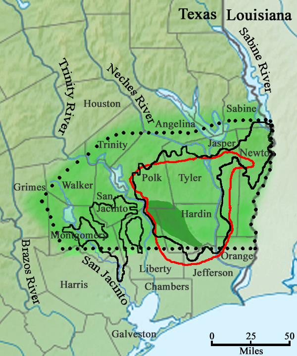
Various interpretations of the Big Thicket: Dark green shading = Traditional "Hunter's Thicket"; Light green shading = Biological Survey; Solid black line = Ecological Analysis; Dotted black line = Primitive Big Thicket Region.
Summary
[edit]
| Description |
English: Various interpretations of the Big Thicket: Dark green shading = Traditional "Hunter's Thicket" (Ajilvsgi, 1979); Light green shading = Biological Survey (Parks et al., 1936); Solid black line = Ecological Analysis (McLeod, 1972); Dotted black line = Primitive Big Thicket Region (Peacock, 1994).
This is a map illustrating four different interpretations of the Big Thicket region of southeast Texas based on: Ajilvsgi, Geyata (1979) Wild Flowers of the Big Thicket: East Texas, and Western Louisiana. Texas A&M University Press. College Station, Texas 361 pp. 0-89096-064-X; McLeod, C. A. (1972) The Big Thicket forest of eastern Texas. Sam Houston State University Huntsville, Texas. 33pp.; Parks, H. B, V. L. Cory, et al. (1936) Biological survey of the East Texas Big Thicket area: The fauna and flora of the Big Thicket area. Special Publication by the sponsored by Texas Academy of Sciences. Privately Published. 51 pp.; Peacock, Howard (1994) Nature Lover's Guide to the Big Thicket. Texas A&M. University Press. College Station, Texas. 169 pp. ISBN 0-89096-589-7 |
| Date | |
| Source | Own work |
| Author | William L. Farr |
Licensing
[edit]
I, the copyright holder of this work, hereby publish it under the following license:
This file is licensed under the Creative Commons Attribution-Share Alike 4.0 International license.
- You are free:
- to share – to copy, distribute and transmit the work
- to remix – to adapt the work
- Under the following conditions:
- attribution – You must give appropriate credit, provide a link to the license, and indicate if changes were made. You may do so in any reasonable manner, but not in any way that suggests the licensor endorses you or your use.
- share alike – If you remix, transform, or build upon the material, you must distribute your contributions under the same or compatible license as the original.
File history
Click on a date/time to view the file as it appeared at that time.
| Date/Time | Thumbnail | Dimensions | User | Comment | |
|---|---|---|---|---|---|
| current | 05:34, 29 November 2019 | | 600 × 720 (404 KB) | Wilafa (talk | contribs) | Added a fifth interpretation of the Big Thicket boundary (red line) based on geological and ecological analysis from Watson, Geraldine Ellis (2006) Big Thicket Plant Ecology: An Introduction, Third Edition (Temple Big Thicket Series #5). University of North Texas Press. 152 pp. ISBN 978-1574412147 |
| 21:38, 18 November 2019 |  | 600 × 720 (389 KB) | Wilafa (talk | contribs) | User created page with UploadWizard |
You cannot overwrite this file.
File usage on Commons
There are no pages that use this file.
File usage on other wikis
The following other wikis use this file:
- Usage on en.wikipedia.org