File:Blade End (FindID 50102).jpg
Jump to navigation
Jump to search

Size of this preview: 800 × 600 pixels. Other resolutions: 320 × 240 pixels | 640 × 480 pixels | 1,024 × 768 pixels | 1,280 × 960 pixels | 2,272 × 1,704 pixels.
Original file (2,272 × 1,704 pixels, file size: 807 KB, MIME type: image/jpeg)
Captions
Captions
Add a one-line explanation of what this file represents
Summary
[edit].jpg&action=edit§ion=1)
| Blade End | |||
|---|---|---|---|
| Photographer |
The Portable Antiquities Scheme, Kathryn Rees, 2003-07-22 16:15:32 |
||
| Title |
Blade End |
||
| Description |
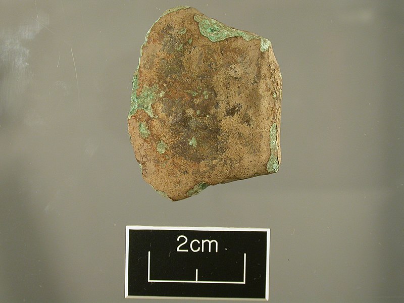
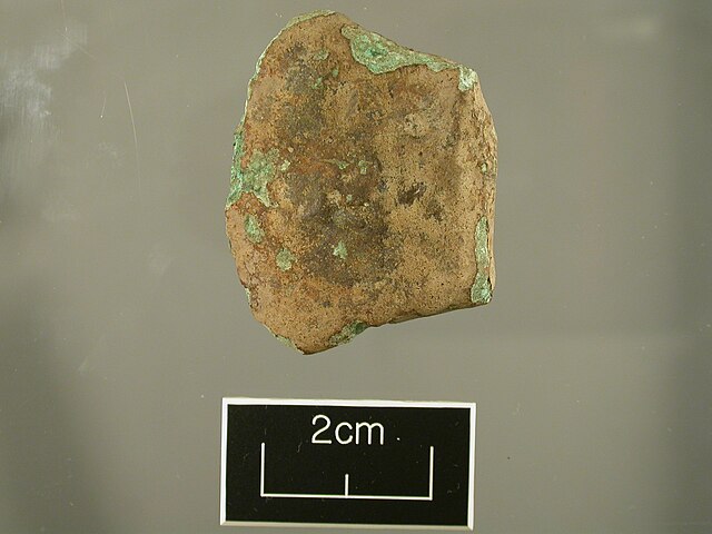
English: This is a blade end fragment of an indeterminate Middle or Late Bronze Age axe. The broken section has eroded, making it difficult to determine if the axe has fractured at the bottom of the socket of a socketed axe of Late Bronze Age type, or through a solid palstave of the Middle to Late Bronze age. The axe fragment has the remnants of a single rib running down one of the faces. The other face is irregular with large pitting, which may have been a feature of the axe, rather than a corrosion effect. The blade edge has been lost through corrosion but was originally expanded. The axe would have been of slender form, perhaps suggesting a ribbed palstave rather than a socketed axe.
The original surface of the axe has a light to mid brown patina, but has areas of active green corrosion through the surface. |
||
| Depicted place | (County of findspot) Pembrokeshire | ||
| Date | BRONZE AGE | ||
| Accession number |
FindID: 50102 Old ref: NMGW-D513A1 Filename: DSCN0119.JPG |
||
| Credit line |
|
||
| Source |
https://finds.org.uk/database/ajax/download/id/5843 Catalog: https://finds.org.uk/database/images/image/id/5843/recordtype/artefacts archive copy at the Wayback Machine Artefact: https://finds.org.uk/database/artefacts/record/id/50102 |
||
| Permission (Reusing this file) |
Attribution-ShareAlike License | ||
| Object location | | View this and other nearby images on: OpenStreetMap |
|---|
.jpg¶ms=051.838800_N_-004.951710_E_globe:Earth_class:object_type:object__&language=en)
Licensing
[edit].jpg&action=edit§ion=2)
This file is licensed under the Creative Commons Attribution-Share Alike 2.0 Generic license.
Attribution: The Portable Antiquities Scheme/ The Trustees of the British Museum
- You are free:
- to share – to copy, distribute and transmit the work
- to remix – to adapt the work
- Under the following conditions:
- attribution – You must give appropriate credit, provide a link to the license, and indicate if changes were made. You may do so in any reasonable manner, but not in any way that suggests the licensor endorses you or your use.
- share alike – If you remix, transform, or build upon the material, you must distribute your contributions under the same or compatible license as the original.
File history
Click on a date/time to view the file as it appeared at that time.
| Date/Time | Thumbnail | Dimensions | User | Comment | |
|---|---|---|---|---|---|
| current | 03:12, 30 January 2017 | | 2,272 × 1,704 (807 KB) | Fæ (talk | contribs) | Portable Antiquities Scheme, NMGW, FindID: 50102, bronze age, page 296, batch count 4994 |
You cannot overwrite this file.
File usage on Commons
The following 2 pages use this file:
.jpg)
.jpg)
.jpg&oldid=825243364)