File:Blade end (FindID 86970).jpg

Original file (2,272 × 1,704 pixels, file size: 1.42 MB, MIME type: image/jpeg)
Captions
Captions
Summary
[edit].jpg&action=edit§ion=1)
| Blade end | |||
|---|---|---|---|
| Photographer |
The Portable Antiquities Scheme, Katrina Deering, 2005-02-08 15:35:34 |
||
| Title |
Blade end |
||
| Description |
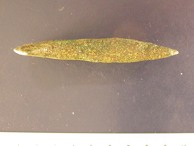
English: Bronze developed flat axe (or flanged axe), probably of Type Glenalla (following Schmidt and Burgess 1981) or Class 4 (following Needham 1983; forthcoming) and dating to the Early Bronze Age, Period 3 (1950-1750 BC) (Needham 1996).
The axehead is a small example with a length of 77.8mm, and is also comparatively slender with a width at the bevel of 19.9mm. The butt is rounded and the sides are near-parallel (with a width at the butt of 18.2mm) as far as the bevel. After the bevel, the sides curve very gently outwards as far as the blade, where the sides turn out sharply to the blade tips, producing an expanded cutting edge with a surviving width of 39.0mm. The edges of the faces are raised slightly (1mm), but have been eroded and the sides are convex across their thickness. The faces are flat either side of the bevel, which is positioned 34mm from the butt. The blade begins 17mm from the edge. The surface of the axe has been largely lost, in addition to the cutting edge and one of the blade tips. |
||
| Depicted place | (County of findspot) Hampshire | ||
| Date | between 1950 BC and 1750 BC | ||
| Accession number |
FindID: 86970 Old ref: NMGW-8D6411 Filename: DSCN2489.JPG |
||
| Credit line |
|
||
| Source |
https://finds.org.uk/database/ajax/download/id/50725 Catalog: https://finds.org.uk/database/images/image/id/50725/recordtype/artefacts archive copy at the Wayback Machine Artefact: https://finds.org.uk/database/artefacts/record/id/86970 |
||
| Permission (Reusing this file) |
Attribution-ShareAlike License | ||
| Object location | | View this and other nearby images on: OpenStreetMap |
|---|
.jpg¶ms=051.289800_N_-001.221910_E_globe:Earth_class:object_type:object__&language=en)
Licensing
[edit].jpg&action=edit§ion=2)
- You are free:
- to share – to copy, distribute and transmit the work
- to remix – to adapt the work
- Under the following conditions:
- attribution – You must give appropriate credit, provide a link to the license, and indicate if changes were made. You may do so in any reasonable manner, but not in any way that suggests the licensor endorses you or your use.
- share alike – If you remix, transform, or build upon the material, you must distribute your contributions under the same or compatible license as the original.
File history
Click on a date/time to view the file as it appeared at that time.
| Date/Time | Thumbnail | Dimensions | User | Comment | |
|---|---|---|---|---|---|
| current | 17:20, 30 April 2019 | | 2,272 × 1,704 (1.42 MB) | Fæ (talk | contribs) | Portable Antiquities Scheme, NMGW, FindID: 86970, bronze age, page 29659, batch count 714 |
You cannot overwrite this file.
File usage on Commons
The following page uses this file:
.jpg)
.jpg&oldid=825243833)