File:Borobudur Location Java.png
Jump to navigation
Jump to search
No higher resolution available.
Borobudur_Location_Java.png (258 × 166 pixels, file size: 35 KB, MIME type: image/png)
Captions
Captions
Add a one-line explanation of what this file represents
Summary
[edit]
| Description |
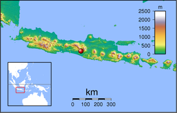
English: Topographic location map of Java (Indonesia). Created with GMT from SRTM data
Left: 104.5, Right: 117.0, Bottom: -12.0666667 Top: -4.0. For non-locator version, see Image:Java Topography.png |
| Date | |
| Source | Own work |
| Author | Sadalmelik - FR (Borobudur point from Wikipedia:en) |
Licensing
[edit]
| I, the copyright holder of this work, release this work into the public domain. This applies worldwide. In some countries this may not be legally possible; if so: I grant anyone the right to use this work for any purpose, without any conditions, unless such conditions are required by law. |
File history
Click on a date/time to view the file as it appeared at that time.
| Date/Time | Thumbnail | Dimensions | User | Comment | |
|---|---|---|---|---|---|
| current | 17:13, 2 March 2009 | | 258 × 166 (35 KB) | FR (talk | contribs) | {{Information |Description={{en|1=TBA}} |Source=Own work by uploader |Author=FR |Date= |Permission= |other_versions= }} <!--{{ImageUpload|full}}--> |
You cannot overwrite this file.
File usage on Commons
The following page uses this file:
File usage on other wikis
The following other wikis use this file:
- Usage on it.wikivoyage.org
- Usage on stq.wikipedia.org