File:Bosnia and Herzegovina location map.svg
Zur Navigation springen
Zur Suche springen

Gröössi vor PNG-Vorschou vor SVG-Datei: 628 × 599 Pixel. Wyteri Ufflösige: 252 × 240 Pixel | 503 × 480 Pixel | 805 × 768 Pixel | 1.074 × 1.024 Pixel | 2.147 × 2.048 Pixel | 1.063 × 1.014 Pixel.
Originaldatei (SVG-Datei, Basisgrößi: 1.063 × 1.014 Pixel, Dateigrößi: 141 KB)
Bildtexte
Kurzbeschreibungen
Ergänze eine einzeilige Erklärung, was diese Datei darstellt.
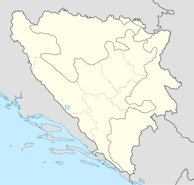
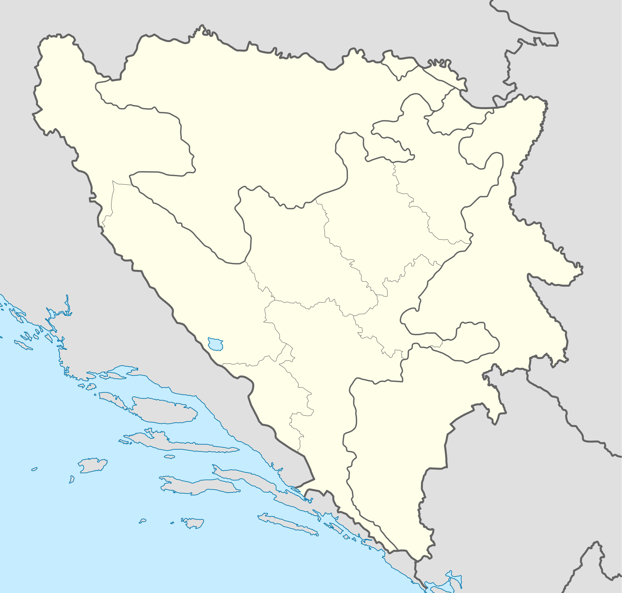
Karte von Bosnien und Herzegowina
Bschryybig
[ändere]| Bschryybig |
Deutsch: Positionskarte von Bosnien und Herzegowina
Quadratische Plattkarte, N-S-Streckung 140 %. Geographische Begrenzung der Karte:
English: Location map of Bosnia and Herzegovina
Equirectangular projection, N/S stretching 140 %. Geographic limits of the map:
|
| Datum | |
| Quälle | own work, using United States National Imagery and Mapping Agency data |
| Urheber | NordNordWest |
| Anderi Versione |
|


|
Diese Karte wurde in der Kartenwerkstatt erstellt oder verbessert. Auch du kannst dort Karten vorschlagen, die zu erstellen, verändern oder übersetzen sind.
|
Lizänzierig
[ändere]
Ich haa s Urheberrächt an däm Wärch un vereffetlig s dodermit unter däne Lizänze:

|
Des Dokumänt derf kopiert, verbreitet un/oder bearbeitet wäre unter dr Bedingige vu dr GNU-Lizänz fir freji Dokumäntation, Version 1.2 oder ere spetere Version, vereffetligt dur Free Software Foundation. S het keini uuveränderlige Abschnitt, kei vordere Umschlagstext un kei hindere Umschlagstext. E Kopii vu dr Lizänz isch verfiegbar im Abschnitt GNU-Lizänz fir freji Dokumäntation. |
Die Datei isch lizänziert unter dr Creative-Commons-Lizenz Namensnännig – Wytergab unter glyche Bedingige 3.0 nit portiert.
- Du derfsch:
- des Wärch an anderi wytergee – des Wärch kopiere, verbreite un ibertrage
- des Wärch verändere – des Wärch aapasse
- Unter däne Bedingige:
- Namenännig – Du muesch aagmässeni Aagabe zum Urheber un dr Rächt mache, e Link zue dr Lizänz zuefiege un aagee, eb Änderige gmacht wore sin. Die Aagabe chenne in ere aagmässene Art gmacht wäre, aber nit eso, ass dr Yydruck entstoht, ass dr Lizänzgeber Dii oder Dyy Gebruch vum Wärch unterstitze un guetheiße.
- Wytergab unter glyche Bedingige – Wänn du des Wärch veränderesch, umwandlesch oder druf ufböusch, no derfsch s Ergebnis nume unter dr glyche oder ere kumpatible Lizänz wie s Orginal vereffetlige.
Du chasch sälber e Lizänz uuswehle.
Dateiversione
Klick uf e Zytpunkt zu aazeige, wie s dert usgsäh het.
| Version vom | Vorschaubild | Mäß | Benutzer | Kommentar | |
|---|---|---|---|---|---|
| aktuell | 19:21, 10. Nov. 2011 | | 1.063 × 1.014 (141 KB) | NordNordWest (Diskussion | Byträg) | at least we should keep lake Buško |
| 18:22, 10. Nov. 2011 |  | 1.063 × 1.014 (143 KB) | Mostarac (Diskussion | Byträg) | Regije u RS-u imaju samo statističku funkciju, za razliku od županija/kantona u FBiH, koje su uprave podjedinice! | |
| 11:06, 3. Okt. 2011 |  | 1.063 × 1.014 (148 KB) | NordNordWest (Diskussion | Byträg) | upd | |
| 16:19, 27. Sep. 2011 |  | 1.063 × 1.014 (143 KB) | AnelZukic (Diskussion | Byträg) | once again reverted the changes, I'm givin up | |
| 16:16, 27. Sep. 2011 | Kei Vorschaubild vorhande | 0 × 0 (4,63 MB) | AnelZukic (Diskussion | Byträg) | added Republika Srpka regions | |
| 15:08, 27. Sep. 2011 |  | 1.063 × 1.014 (143 KB) | AnelZukic (Diskussion | Byträg) | reverted the changes | |
| 15:03, 27. Sep. 2011 |  | 1.280 × 1.208 (35 KB) | AnelZukic (Diskussion | Byträg) | Added regions in Republika Srpska | |
| 14:19, 11. Apr. 2011 |  | 1.063 × 1.014 (143 KB) | NordNordWest (Diskussion | Byträg) | upd | |
| 18:48, 25. Aug. 2008 |  | 1.064 × 1.016 (223 KB) | NordNordWest (Diskussion | Byträg) | size correction | |
| 19:37, 30. Jul. 2008 |  | 709 × 677 (220 KB) | NordNordWest (Diskussion | Byträg) | {{Information |Description= {{de|Positionskarte von Bosnien und Herzegowina}} Quadratische Plattkarte, N-S-Streckung 140 %. Geographische Begrenzung der Karte: * N: 45.4° N * S: 42.4° N * W: 15.5° O * O: 19.9° O {{en|Lo |
Du chasch die Datei nit iberschryybe.
Verwändig vu dr Datei
Die 24 Syte bruuche die Datei:
- Atlas of Bosnia and Herzegovina
- Atlas of Republika Srpska
- User:NordNordWest/Gallery/Location maps
- File:Bosnia and Herzegovina location map-2.svg
- File:Bosnia and Herzegovina relief location map.png
- File:Bosnia and Herzegovina relief location map.svg
- File:Bosnian Podrinje in Federation of Bosnia and Herzegovina.svg
- File:Brcko District in Bosnia and Herzegovina.svg
- File:Brcko District in Bosnia and Herzegovina (hatched).svg
- File:Canton 10 in Federation of Bosnia and Herzegovina.svg
- File:Central Bosnia in Federation of Bosnia and Herzegovina.svg
- File:EUFOR Althea logo.svg
- File:Federation of Bosnia and Herzegovina in Bosnia and Herzegovina.svg
- File:Federation of Bosnia and Herzegovina in Bosnia and Herzegovina (wo Brcko District).svg
- File:Herzegovina-Neretva in Federation of Bosnia and Herzegovina.svg
- File:Posavina in Federation of Bosnia and Herzegovina.svg
- File:Republika Srpska in Bosnia and Herzegovina.svg
- File:Republika Srpska in Bosnia and Herzegovina (wo Brcko District).svg
- File:Sarajevo in Federation of Bosnia and Herzegovina.svg
- File:Tropolje map.png
- File:Tuzla in Federation of Bosnia and Herzegovina.svg
- File:Una-Sana in Federation of Bosnia and Herzegovina.svg
- File:West Herzegovina in Federation of Bosnia and Herzegovina.svg
- File:Zenica-Doboj in Federation of Bosnia and Herzegovina.svg
.svg)
.svg)
.svg)
Wältwyti Dateinutzig
Die andere Wikis bruche die Datei:
- Gebruch uf af.wikipedia.org
- Gebruch uf als.wikipedia.org
- Gebruch uf an.wikipedia.org
- Gebruch uf ar.wikipedia.org
- Gebruch uf arz.wikipedia.org
- Gebruch uf ast.wikipedia.org
- Gebruch uf av.wikipedia.org
- Gebruch uf azb.wikipedia.org
- Gebruch uf az.wikipedia.org
Wältwyti Verwändig vu däre Datei aaluege.