File:Boulder Bridge Cutaway - Boulder Bridge, Spanning Rock Creek at Beach Drive, South of Joyce Road, Washington, District of Columbia, DC HAER DC,WASH,564- (sheet 2 of 2).png
Jump to navigation
Jump to search

Size of this preview: 800 × 534 pixels. Other resolutions: 320 × 213 pixels | 640 × 427 pixels | 1,024 × 683 pixels | 1,280 × 854 pixels | 2,560 × 1,708 pixels | 14,440 × 9,632 pixels.
Original file (14,440 × 9,632 pixels, file size: 5.6 MB, MIME type: image/png)
Captions
Captions
Add a one-line explanation of what this file represents
| This image is a JPEG version of the original TIF image at File: Boulder Bridge Cutaway - Boulder Bridge, Spanning Rock Creek at Beach Drive, South of Joyce Road, Washington, District of Columbia, DC HAER DC,WASH,564- (sheet 2 of 2).tif.
However, any edits to the image should be based on the original TIF version in order to prevent generation loss, and both versions should be updated. Do not make edits based on this version. |
Summary
[edit]| Warning | The original file is very high-resolution. It might not load properly or could cause your browser to freeze when opened at full size. |
|---|
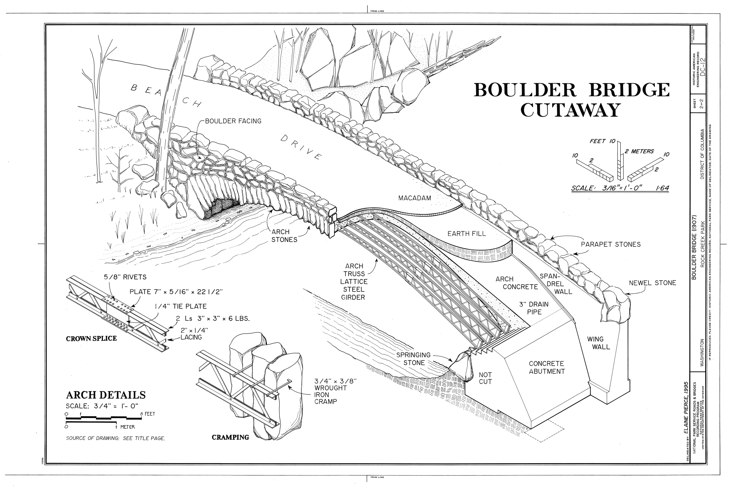
| Boulder Bridge Cutaway - Boulder Bridge, Spanning Rock Creek at Beach Drive, South of Joyce Road, Washington, District of Columbia, DC | ||||
|---|---|---|---|---|
| Photographer |
Pierce, Elaine, creator |
|||
| Title |
Boulder Bridge Cutaway - Boulder Bridge, Spanning Rock Creek at Beach Drive, South of Joyce Road, Washington, District of Columbia, DC |
|||
| Depicted place | District of Columbia; District of Columbia; Washington | |||
| Date | 1995 | |||
| Dimensions | 24 x 36 in. (D size) | |||
| Current location |
Library of Congress Prints and Photographs Division Washington, D.C. 20540 USA http://hdl.loc.gov/loc.pnp/pp.print |
|||
| Accession number |
HAER DC,WASH,564- (sheet 2 of 2) |
|||
| Credit line |
|
|||
| Notes |
|
|||
| References |
Related names:
|
|||
| Source | https://www.loc.gov/pictures/item/dc0625.sheet.00002a | |||
| Permission (Reusing this file) |
|
|||
| Other versions |
.png) |
|||

.png&action=edit§ion=1)
.png&flash=no)
| Object location | | View this and other nearby images on: OpenStreetMap |
|---|
.png¶ms=038.895000_N_-077.036670_E_globe:Earth_class:object_type:object__&language=en)
File history
Click on a date/time to view the file as it appeared at that time.
| Date/Time | Thumbnail | Dimensions | User | Comment | |
|---|---|---|---|---|---|
| current | 23:12, 18 July 2014 | | 14,440 × 9,632 (5.6 MB) | Fæ (talk | contribs) | {{Compressed version|file=File:Boulder_Bridge_Cutaway_-_Boulder_Bridge,_Spanning_Rock_Creek_at_Beach_Drive,_South_of_Joyce_Road,_Washington,_District_of_Columbia,_DC_HAER_DC,WASH,564-_(sheet_2_of_2).tif|thumb=nothumb}} =={{int:filedesc}}== {{Photograp... |
You cannot overwrite this file.
File usage on Commons
The following 4 pages use this file:
- File:Boulder Bridge, 1902, Title Page - Boulder Bridge, Spanning Rock Creek at Beach Drive, South of Joyce Road, Washington, District of Columbia, DC HAER DC,WASH,564- (sheet 1 of 2).png
- File:Boulder Bridge, 1902, Title Page - Boulder Bridge, Spanning Rock Creek at Beach Drive, South of Joyce Road, Washington, District of Columbia, DC HAER DC,WASH,564- (sheet 1 of 2).tif
- File:Boulder Bridge Cutaway - Boulder Bridge, Spanning Rock Creek at Beach Drive, South of Joyce Road, Washington, District of Columbia, DC HAER DC,WASH,564- (sheet 2 of 2).png
- File:Boulder Bridge Cutaway - Boulder Bridge, Spanning Rock Creek at Beach Drive, South of Joyce Road, Washington, District of Columbia, DC HAER DC,WASH,564- (sheet 2 of 2).tif
.png)
.png&oldid=830654678)