File:Boundary Stone (District of Columbia) SW 2.jpg
Jump to navigation
Jump to search

Size of this preview: 600 × 600 pixels. Other resolutions: 240 × 240 pixels | 480 × 480 pixels | 768 × 768 pixels | 1,024 × 1,024 pixels.
Original file (1,024 × 1,024 pixels, file size: 699 KB, MIME type: image/jpeg)
Captions
Captions
Add a one-line explanation of what this file represents
Summary
[edit]_SW_2.jpg&action=edit§ion=1)
| Description |
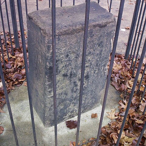
English: DC Boundary Stone Southwest Mile 2, that is the boundary marker 2 miles NW of the southernmost marker of the original District of Columbia, now in northern Virginia. The stone was placed in 1791-1792 by Andrew Ellicott and Benjamin Banneker. See zhurnaly.com/maps/DC_Boundary_Stones.html for a map of these stones. |
| Date | |
| Source | https://www.flickr.com/photos/zhurnaly/81112825/sizes/l/in/set-1352644/ |
| Author | zhurnaly (Mark Zimmermann) |
Licensing
[edit]_SW_2.jpg&action=edit§ion=2)
| This image was originally posted to Flickr by zhurnaly at https://www.flickr.com/photos/27469825@N00/81112825. It was reviewed on 5 August 2011 by FlickreviewR and was confirmed to be licensed under the terms of the cc-by-2.0. |
This file is licensed under the Creative Commons Attribution 2.0 Generic license.
- You are free:
- to share – to copy, distribute and transmit the work
- to remix – to adapt the work
- Under the following conditions:
- attribution – You must give appropriate credit, provide a link to the license, and indicate if changes were made. You may do so in any reasonable manner, but not in any way that suggests the licensor endorses you or your use.
File history
Click on a date/time to view the file as it appeared at that time.
| Date/Time | Thumbnail | Dimensions | User | Comment | |
|---|---|---|---|---|---|
| current | 01:16, 5 August 2011 | | 1,024 × 1,024 (699 KB) | Smallbones (talk | contribs) |
You cannot overwrite this file.
File usage on Commons
The following page uses this file:
- File:DC SW Mile 2 Boundary.jpg (file redirect)
File usage on other wikis
The following other wikis use this file:
- Usage on en.wikipedia.org
_SW_2.jpg&oldid=830723253)