File:Brasil bergland.jpg
Jump to navigation
Jump to search

Size of this preview: 591 × 599 pixels. Other resolutions: 237 × 240 pixels | 474 × 480 pixels | 758 × 768 pixels | 1,010 × 1,024 pixels | 1,400 × 1,419 pixels.
Original file (1,400 × 1,419 pixels, file size: 1.21 MB, MIME type: image/jpeg)
Captions
Captions
Add a one-line explanation of what this file represents
Summary
[edit]
| Description |
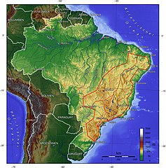
Deutsch: Das brasilianische Bergland, grob und mit zittriger Hand abgegrenzt vom Rest des Landes zu reinen Verdeutlichungszwecken (nur um mal dem ewigen "Brasilien ist Amazonien, und Amazonien ist tellereben" entgegenzuwirken).
Русский: Физическая карта бразильского нагорья. |
| Date | 13 October 2005 (original upload date) |
| Source |
File:Brasilien topo.jpg" von englischer Wiki wurde hier ergänzt um die rote Linie Quelle dort: Own work using Generic Mapping Tools (http://gmt.soest.hawaii.edu/)
|
| Author |
|
Licensing
[edit]

|
Permission is granted to copy, distribute and/or modify this document under the terms of the GNU Free Documentation License, Version 1.2 or any later version published by the Free Software Foundation; with no Invariant Sections, no Front-Cover Texts, and no Back-Cover Texts. A copy of the license is included in the section entitled GNU Free Documentation License. |
| This file is licensed under the Creative Commons Attribution-Share Alike 3.0 Unported license. | ||
| ||
| This licensing tag was added to this file as part of the GFDL licensing update. |
Original upload log
[edit]
The original description page was here. All following user names refer to de.wikipedia.
- 2005-10-13 15:19 Fim 1400×1419× (820057 bytes) Das brasilianische Bergland, grob und mit zittriger Hand abgegrenzt vom Rest des Landes zu reinen Verdeutlichungszwecken (nur um mal dem ewigen "Brasilien ist Amazonien, und Amazonien ist tellereben" entgegenzuwirken). Original "Brasilien topo.jpg" von e
File history
Click on a date/time to view the file as it appeared at that time.
| Date/Time | Thumbnail | Dimensions | User | Comment | |
|---|---|---|---|---|---|
| current | 11:48, 24 September 2021 | | 1,400 × 1,419 (1.21 MB) | Fährtenleser (talk | contribs) | Dreitieilung in Atlantisches-, Zentrales- u. Südliches Plateau hinzugefügt |
| 01:45, 4 September 2011 |  | 1,400 × 1,419 (801 KB) | File Upload Bot (Magnus Manske) (talk | contribs) | {{BotMoveToCommons|de.wikipedia|year={{subst:CURRENTYEAR}}|month={{subst:CURRENTMONTHNAME}}|day={{subst:CURRENTDAY}}}} {{Information |Description={{de|Das brasilianische Bergland, grob und mit zittriger Hand abgegrenzt vom Rest des Landes zu reinen Verde |
You cannot overwrite this file.
File usage on Commons
There are no pages that use this file.
File usage on other wikis
The following other wikis use this file:
- Usage on ba.wikipedia.org
- Usage on be-tarask.wikipedia.org
- Usage on be.wikipedia.org
- Usage on bg.wikipedia.org
- Usage on de.wikipedia.org
- Usage on dz.wikipedia.org
- Usage on es.wikipedia.org
- Usage on hu.wikipedia.org
- Usage on hy.wikipedia.org
- Usage on it.wikipedia.org
- Usage on lij.wikipedia.org
- Usage on mn.wikipedia.org
- Usage on nl.wikipedia.org
- Usage on nl.wiktionary.org
- Usage on pt.wikipedia.org
- Usage on ru.wikipedia.org
- Usage on sw.wikipedia.org