File:BritishWestFlorida1776.jpg
Jump to navigation
Jump to search

Size of this preview: 800 × 415 pixels. Other resolutions: 320 × 166 pixels | 640 × 332 pixels | 1,024 × 531 pixels | 1,752 × 908 pixels.
Original file (1,752 × 908 pixels, file size: 597 KB, MIME type: image/jpeg)
Captions
Captions
Add a one-line explanation of what this file represents
Summary[edit]
| Description |
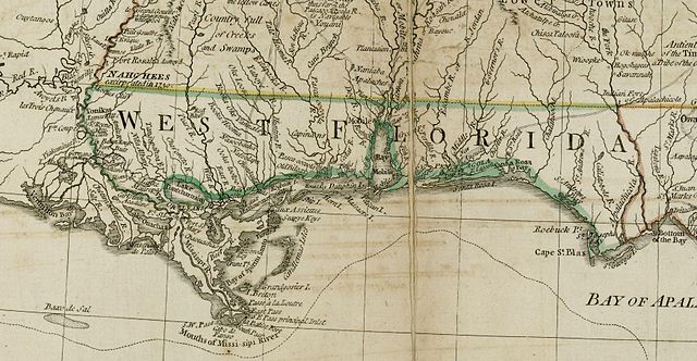
English: The source map depicts the southern British colonies in 1776, including the Carolinas, Georgia, and the Floridas, as well as labeling Indian tribal regions. This detail depicts British West Florida, roughly including the Gulf Coast between the Mississippi River and the Apalachicola River. |
| Date | |
| Source | From the Darlington Digital Library at the University of Pittsburgh, identifier DARMAP0298: http://images.library.pitt.edu/cgi-bin/i/image/image-idx?med=1;image_search%20btn=Go;q1=florida;rgn1=darlmaps_all;sid=9f1d2a0afbb2d02f51e12f6a87a01616;size=20;c=darlmaps;lasttype=boolean;view=entry;lastview=thumbnail;subview=detail;cc=darlmaps;entryid=x-darmap0298;viewid=DARMAP0298.TIF;start=1;resnum=7 |
| Author | Bernard Romans |
Licensing[edit]
|
This work is in the public domain in its country of origin and other countries and areas where the copyright term is the author's life plus 100 years or fewer. | |
| This file has been identified as being free of known restrictions under copyright law, including all related and neighboring rights. | |
File history
Click on a date/time to view the file as it appeared at that time.
| Date/Time | Thumbnail | Dimensions | User | Comment | |
|---|---|---|---|---|---|
| current | 13:02, 5 May 2009 | | 1,752 × 908 (597 KB) | Magicpiano (talk | contribs) | {{Information |Description={{en|1=The source map depicts the southern British colonies in 1776, including the Carolinas, Georgia, and the Floridas, as well as labeling Indian tribal regions. This detail depicts British w:West Florida, roughly includ |
You cannot overwrite this file.
File usage on Commons
The following page uses this file:
File usage on other wikis
The following other wikis use this file:
- Usage on ar.wikipedia.org
- Usage on ca.wikipedia.org
- Usage on en.wikipedia.org
- Usage on es.wikipedia.org
- Usage on fr.wikipedia.org
- Usage on id.wikipedia.org
- Usage on ja.wikipedia.org
- Usage on nl.wikipedia.org
- Usage on ru.wikipedia.org
- Usage on www.wikidata.org