File:Britishindia1855.jpg
Jump to navigation
Jump to search
Size of this preview: 492 × 599 pixels. Other resolutions: 197 × 240 pixels | 504 × 614 pixels.
Original file (504 × 614 pixels, file size: 343 KB, MIME type: image/jpeg)
Captions
Captions
Add a one-line explanation of what this file represents
Summary
[edit]
| Description |
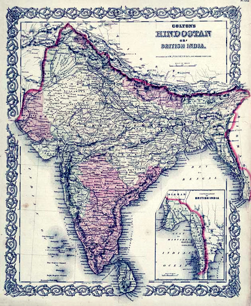
English: Map of British India, 1855. Published by G. W. and C. B. Colton and Company in New York, 1855. It was derived from an earlier wall map of the world produced by Colton and D. Griffing Johnson. Covers the subcontinent from Tibet to Ceylon (Sri Lanka). The map is divided into Bombay, Scinde, Punjab, Nepal, Bhutan, the Bengal Presidency, Madras and Ceylon. An inset map in the lower right quadrant shows British claims in Burma (Pegu) and Southeast Asia. |
| Date | |
| Source | https://www.geographicus.com/P/AntiqueMap/India-colton-1856 |
| Author | Joseph Hutchins Colton (1800-1893) |
Original upload log
[edit]
The original description page was here. All following user names refer to en.wikipedia.
- This was uploaded by me and Azhar Sayed, and comes from our collection. Mrlopez2681 12:32, 28 December 2006 (UTC)
- 2006-12-28 12:32 Mrlopez2681 504×614×8 (156806 bytes) Map of British India, 1855. Published by G. W. and C. B. Colton and Company in New York, 1855. This was uploaded by me, and comes from my collection. ~~~~
Licensing
[edit]
This work is in the public domain in the United States because it was published (or registered with the U.S. Copyright Office) before January 1, 1929.
Public domain works must be out of copyright in both the United States and in the source country of the work in order to be hosted on the Commons. If the work is not a U.S. work, the file must have an additional copyright tag indicating the copyright status in the source country.
Note: This tag should not be used for sound recordings. |
File history
Click on a date/time to view the file as it appeared at that time.
| Date/Time | Thumbnail | Dimensions | User | Comment | |
|---|---|---|---|---|---|
| current | 12:12, 11 September 2012 | | 504 × 614 (343 KB) | Yann (talk | contribs) | white balance, contrast, color corrections |
| 15:37, 26 December 2007 |  | 504 × 614 (153 KB) | Andronicus92 (talk | contribs) | {{Information |Description={{en|Map of British India, 1855. Published by G. W. and C. B. Colton and Company in New York, 1855. This was uploaded by me and Azhar Sayed, and comes from our collection. Mrlopez2681 12:32, 28 December |
You cannot overwrite this file.
File usage on Commons
There are no pages that use this file.
File usage on other wikis
The following other wikis use this file:
- Usage on en.wikipedia.org
- Usage on ml.wikipedia.org
- Usage on ro.wikipedia.org