File:Bulgaria geographic map Central Stara Planina bg.svg
Jump to navigation
Jump to search

Size of this PNG preview of this SVG file: 800 × 267 pixels. Other resolutions: 320 × 107 pixels | 640 × 214 pixels | 1,024 × 342 pixels | 1,280 × 427 pixels | 2,560 × 854 pixels | 5,992 × 2,000 pixels.
Original file (SVG file, nominally 5,992 × 2,000 pixels, file size: 16.98 MB)
Captions
Captions
Add a one-line explanation of what this file represents
Summary[edit]
| Description |
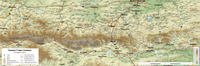
English: Geographic map of Central Stara Planina, Bulgaria in Bulgarian. Geographic limits of the map:
Български: Географска карта на Средна Стара планина. Карта на български. Граници на картата:
|
| Date | |
| Source |
Own work
|
| Author | Ikonact |
| Permission (Reusing this file) |
Any use of this map is subject of the license(s) stated below with the condition that you credit (Wikimedia Commons user: Ikonact) as the author . A message with a reply address would also be greatly appreciated. |

|
This SVG file contains embedded text that can be translated into your language, using any capable SVG editor, text editor or the SVG Translate tool. For more information see: About translating SVG files. |
Licensing[edit]
| This work contains information from OpenStreetMap, which is made available under the Open Database License (ODbL).
The ODbL does not require any particular license for maps produced from ODbL data. Prior to 1 August 2020, map tiles produced by the OpenStreetMap Foundation were licensed under the CC-BY-SA-2.0 license. Maps produced by other people may be subject to other licences. |
I, the copyright holder of this work, hereby publish it under the following license:
This file is licensed under the Creative Commons Attribution-Share Alike 4.0 International license.
- You are free:
- to share – to copy, distribute and transmit the work
- to remix – to adapt the work
- Under the following conditions:
- attribution – You must give appropriate credit, provide a link to the license, and indicate if changes were made. You may do so in any reasonable manner, but not in any way that suggests the licensor endorses you or your use.
- share alike – If you remix, transform, or build upon the material, you must distribute your contributions under the same or compatible license as the original.
File history
Click on a date/time to view the file as it appeared at that time.
| Date/Time | Thumbnail | Dimensions | User | Comment | |
|---|---|---|---|---|---|
| current | 07:25, 20 June 2019 | 5,992 × 2,000 (16.98 MB) | Ikonact (talk | contribs) | note | |
| 20:10, 18 June 2019 | 5,992 × 2,000 (16.98 MB) | Ikonact (talk | contribs) | small improvements | ||
| 20:50, 20 March 2019 | 5,992 × 2,000 (16.98 MB) | Ikonact (talk | contribs) | + road numbers | ||
| 21:50, 19 March 2019 | 5,992 × 2,000 (17.19 MB) | Ikonact (talk | contribs) | == {{int:filedesc}} == {{Information |description={{en|1=Geographic map of Central Stara Planina, Bulgaria in Bulgarian. Geographic limits of the map:}} {{bg|1=Географска карта на Средна Стара планина. Карта на български. Граници на картата:}} *N: 43.10° N *S: 42.50° N *W: 23.95° E *E: 26.40° E Projection: Equidistant Cylindrical |date=2019-03-19 |source={{own}} *Sources of data:<br/> **Topography: NASA SRTM3 v3; **Rivers: Produced using Copernicus data... |
You cannot overwrite this file.
File usage on Commons
There are no pages that use this file.
File usage on other wikis
The following other wikis use this file:
- Usage on bg.wikipedia.org
- Стара планина
- Троянски проход
- Лиса планина
- Габровско
- Златишко-Тетевенска планина
- Микренски височини
- География на Стара планина
- Елено-Твърдишка планина
- Еленски възвишения
- Габровски възвишения
- Васильовска планина
- Лисец (Предбалкан)
- Лествица (планина)
- Стражата (плато)
- Черновръшки рид
- Калоферска планина
- Тревненска планина
- Троянска планина
- Шипченска планина
- Уикипедия:Картография на България/Планини
- Шаблон:ПК Средна Стара планина
- Витата стена
- Дряновско
- Еленско
- Казанлъшко
- Usage on hu.wikipedia.org
- Usage on www.wikidata.org