File:Burn Scars in California (MODIS 2021-06-06).jpg

Original file (2,016 × 1,764 pixels, file size: 539 KB, MIME type: image/jpeg)
Captions
Captions
Summary
[edit].jpg&action=edit§ion=1)
| Description |
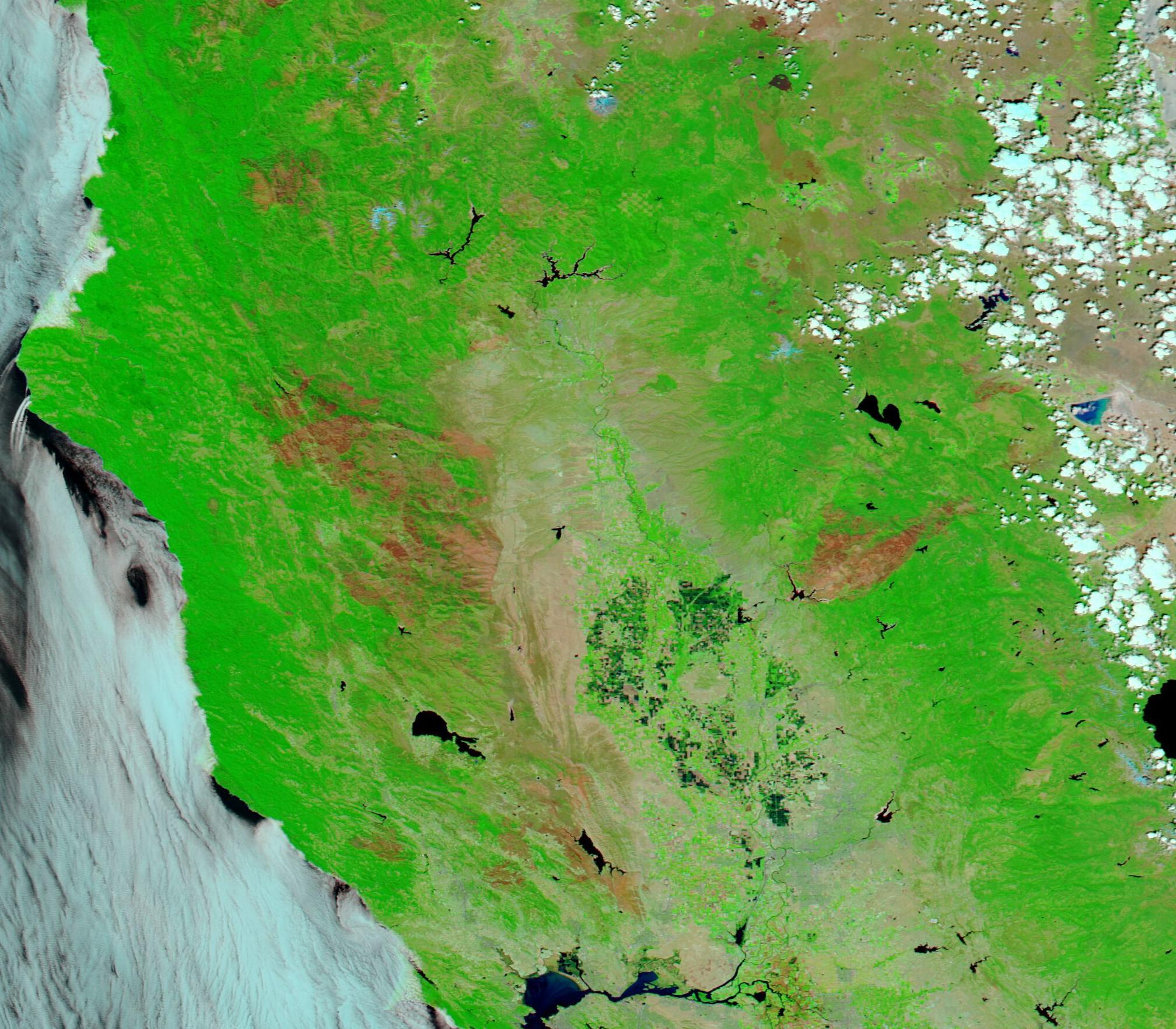
English: On Monday, May 3, 2021, the National Weather Service in Sacramento, California posted a Red Flag Warning for fire danger which spanned a swath from north of Redding to south of Sacramento. The Warning stated, “Critical fire weather conditions will continue through Tuesday afternoon due to gusty north winds and dry conditions. Please practice fire safety!”. Although no large fires ignited during that time, the warning signaled an early start to the California wildfire season, which traditionally has been said to start in late May and end around October. In recent years, the fire season has extended beyond the tradition season and the risk for very large fires have increased, thanks to increasingly warm, dry, and gusty conditions.
The 2020 fire season was particularly difficult, especially from an unprecedented outburst of dry lighting that struck in August, igniting dozens of fires across the state of California. With heat waves and dry weather across most of the state, the fires charred millions of acres, consuming not just forests but also destroying homes, businesses, and lives. Thirty-three people died across California due to wildfire in 2020. Large wildfires cause severe and dramatic damage as they sweep across an area. Swift-moving fires may seem to strike, damage, then disappear—but that is not the case. Fire leaves marks upon the landscape that can last for years. On June 2, 2021, the Moderate Resolution Imaging Spectroradiometer (MODIS) on board NASA’s Aqua satellite acquired a false-color image of northern California, showing the scars left by several years of fire. The false-color image uses visible and near-infrared light (MODIS bands 7,2,1) to help separate burn scars from vegetation. Burn scars – which may appear black, brown, or brick red - stand out in stark contrast to vegetation, which appears bright green. Open land appears tan, deep water is colored deep blue, and clouds may appear either white or tinted with electric blue. The color variation in burn scars depends on type of vegetation burned, the completeness of the burn, the amount of residue remaining after the burn, and the age of the burn. Many of the scars in this image are from the Lightning Complex fires which burned in late 2020, but many are from other or older fires as well. Newer burn scars appear darker in color. As vegetation begins to regrow in burnt areas, the scars begin to take on a greenish tint and become lighter. The darkest green areas which cluster together against a backdrop of lighter green mark agricultural areas in the Sacramento Valley. This agricultural area lies just south of Chico and north of Sacramento. |
||
| Date | Taken on 2 June 2021 | ||
| Source |
Burn Scars in California (direct link)
|
||
| Author | MODIS Land Rapid Response Team, NASA GSFC |
| This media is a product of the Aqua mission Credit and attribution belongs to the mission team, if not already specified in the "author" row |
Licensing
[edit].jpg&action=edit§ion=2)
| This file is in the public domain in the United States because it was solely created by NASA. NASA copyright policy states that "NASA material is not protected by copyright unless noted". (See Template:PD-USGov, NASA copyright policy page or JPL Image Use Policy.) | ||
 |
Warnings:
|
File history
Click on a date/time to view the file as it appeared at that time.
| Date/Time | Thumbnail | Dimensions | User | Comment | |
|---|---|---|---|---|---|
| current | 17:44, 30 January 2024 | | 2,016 × 1,764 (539 KB) | OptimusPrimeBot (talk | contribs) | #Spacemedia - Upload of http://modis.gsfc.nasa.gov/gallery/images/image06062021_250m.jpg via Commons:Spacemedia |
You cannot overwrite this file.
File usage on Commons
There are no pages that use this file.
.jpg&oldid=880861389)