File:C71192s1 Ant.Map Ebbe Glacier.jpg
跳至導覽
跳至搜尋
預覽大小:643 × 600 像素。 其他解析度:257 × 240 像素 | 515 × 480 像素 | 823 × 768 像素 | 1,098 × 1,024 像素 | 2,196 × 2,048 像素 | 3,507 × 3,271 像素。
原始檔案 (3,507 × 3,271 像素,檔案大小:1.71 MB,MIME 類型:image/jpeg)
說明
說明
添加單行說明來描述出檔案所代表的內容
摘要
[編輯]
| 描述 |
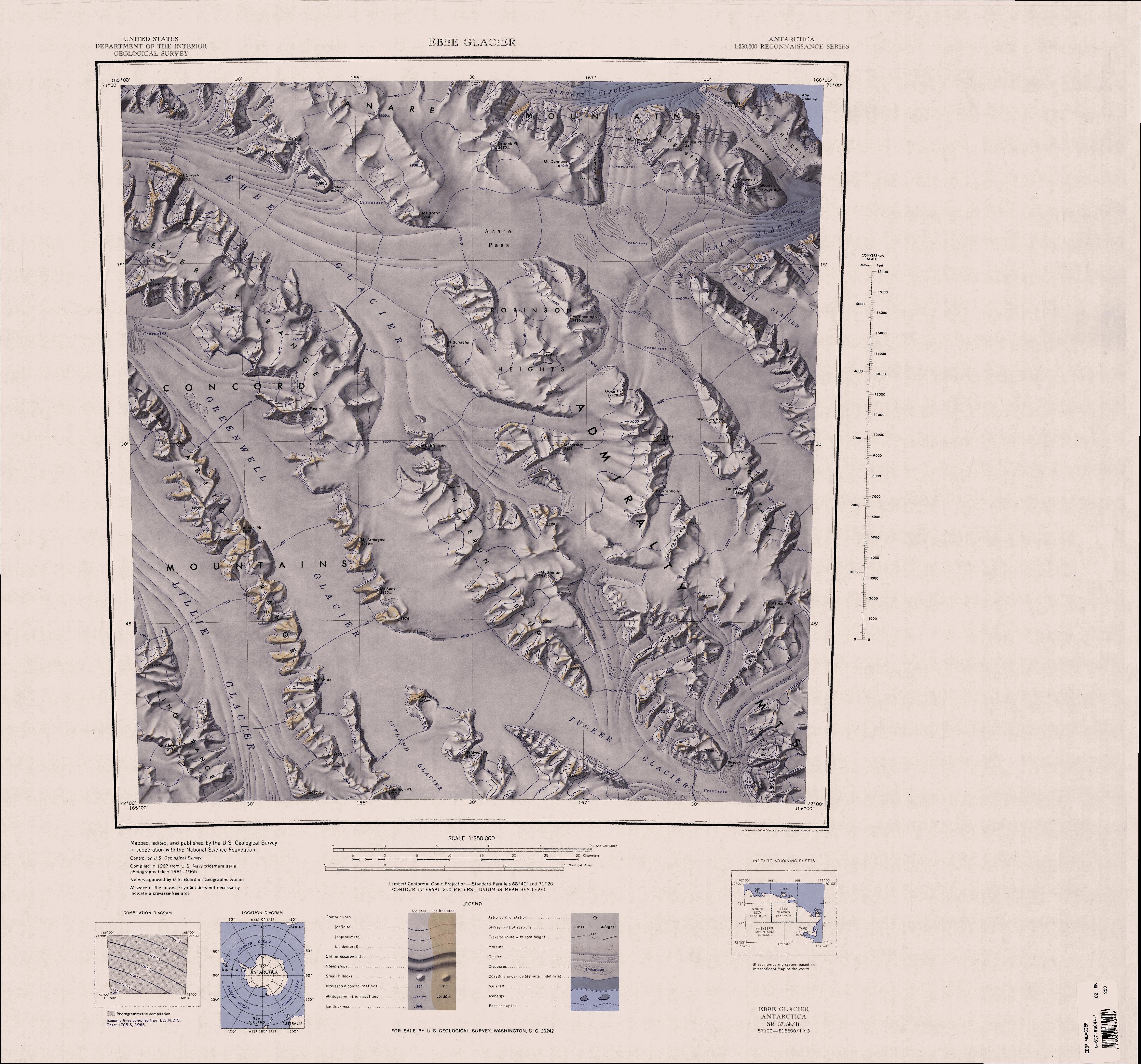
English: 1:250,000-scale topographic reconnaissance map of the Ebbe Glacier area in the Admiralty Range from 165°-168°E to 71°-72°S in Antarctica, including Greenwell, Lillie and Tucker Glacier. Mapped, edited and published by the U.S. Geological Survey in cooperation with the National Science Foundation. |
|||
| 日期 | ||||
| 來源 | http://usarc.usgs.gov/drg_dload.shtml | |||
| 作者 | United States Geological Survey | |||
| 授權許可 (重用此檔案) |
|
檔案歷史
點選日期/時間以檢視該時間的檔案版本。
| 日期/時間 | 縮圖 | 尺寸 | 用戶 | 備註 | |
|---|---|---|---|---|---|
| 目前 | 2005年4月3日 (日) 20:31 | | 3,507 × 3,271(1.71 MB) | Achim Raschka(對話 | 貢獻) | Map of Antarctica by the United States Antarctic Ressource Center of the US Geological Society. {{PD-US}} Copyrights and Trademarks USGS-authored or produced data and information are in the public domain. While the content of most USGS web pages is in th |
無法覆蓋此檔案。
檔案用途
沒有使用此檔案的頁面。
全域檔案使用狀況
以下其他 wiki 使用了這個檔案:
- bg.wikipedia.org 的使用狀況
- ceb.wikipedia.org 的使用狀況
- de.wikipedia.org 的使用狀況
- en.wikipedia.org 的使用狀況
- Admiralty Mountains
- Dennistoun Glacier
- Everett Range
- Lyttelton Range
- Dunedin Range
- Homerun Range
- Anare Mountains
- Lillie Glacier
- Concord Mountains
- Mirabito Range
- King Range (Antarctica)
- Tucker Glacier
- Victory Mountains
- Quam Heights
- Barnett Glacier
- Findlay Range
- Hedgpeth Heights
- Robinson Heights
- McGregor Range (Antarctica)
- he.wikipedia.org 的使用狀況
- it.wikipedia.org 的使用狀況
檢視此檔案的更多全域使用狀況。