File:C74112s5 Ant.Map Martin Peninsula.jpg
跳至導覽
跳至搜尋

預覽大小:581 × 599 像素。 其他解析度:233 × 240 像素 | 465 × 480 像素 | 745 × 768 像素 | 993 × 1,024 像素 | 1,985 × 2,048 像素 | 3,621 × 3,735 像素。
原始檔案 (3,621 × 3,735 像素,檔案大小:1.52 MB,MIME 類型:image/jpeg)
說明
說明
添加單行說明來描述出檔案所代表的內容
摘要
[編輯]
| 描述 |
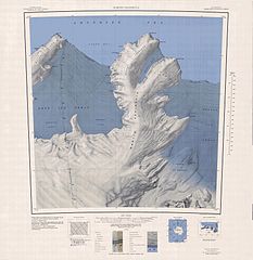
English: 1:250,000-scale topographic reconnaissance map of the Martin Peninsula area from 112°30'-117°W to 73°45'-75°S in Antarctica, including the eastern parts of the Getz Ice Shelf and the western parts of Dotson Ice Shelf. Mapped, edited and published by the U.S. Geological Survey in cooperation with the National Science Foundation. |
|||
| 日期 | ||||
| 來源 | http://usarc.usgs.gov/drg_dload.shtml | |||
| 作者 | United States Geological Survey | |||
| 授權許可 (重用此檔案) |
|
檔案歷史
點選日期/時間以檢視該時間的檔案版本。
| 日期/時間 | 縮圖 | 尺寸 | 使用者 | 備註 | |
|---|---|---|---|---|---|
| 目前 | 2005年4月4日 (一) 06:31 | | 3,621 × 3,735(1.52 MB) | Achim Raschka(留言 | 貢獻) | Map of Antarctica by the United States Antarctic Ressource Center of the US Geological Society. {{PD-US}} Copyrights and Trademarks USGS-authored or produced data and information are in the public domain. While the content of most USGS web pages is in th |
無法覆蓋此檔案。
檔案用途
沒有使用此檔案的頁面。
全域檔案使用狀況
以下其他 wiki 使用了這個檔案:
- ceb.wikipedia.org 的使用狀況
- de.wikipedia.org 的使用狀況
- Martin-Halbinsel
- Kap Felt
- Kap Herlacher
- Binder Rocks
- Siglin Rocks
- Schneider Rock
- Klimov Bluff
- Jenkins Heights
- McClinton-Gletscher
- Spaulding-Halbinsel
- Coyer Point
- Jacobsen Head
- Slichter Foreland
- Dorchuck-Gletscher
- Klinger Ridge
- Ellis Ridge
- Keys-Gletscher
- Furman Bluffs
- Philbin Inlet
- Murray Foreland
- Hadley Point
- Maumee-Piedmont-Gletscher
- Rydelek-Eisfälle
- Smythe Shoulder
- Singer-Gletscher
- Tucker Point
- Nowicki Foreland
- en.wikipedia.org 的使用狀況
- fr.wikipedia.org 的使用狀況
- he.wikipedia.org 的使用狀況
- hi.wikipedia.org 的使用狀況
- it.wikipedia.org 的使用狀況
檢視此檔案的更多全域使用狀況。