File:COVID-19 Germany 7-day prevalence per capita (timeline).webm
Jump to navigation
Jump to search
Size of this JPG preview of this WEBM file: 600 × 600 pixels. Other resolutions: 240 × 240 pixels | 480 × 480 pixels | 921 × 921 pixels.
Original file (WebM audio/video file, VP9, length 1 min 54 s, 921 × 921 pixels, 236 kbps overall, file size: 3.22 MB)
Captions
Captions
COVID-19 Germany 7-day prevalence per capita (timeline)
Summary[edit]
| Description |
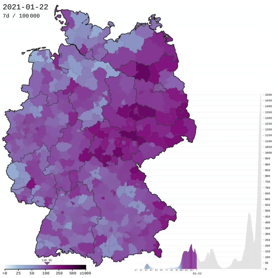
English: COVID-19 in Germany - new cases in 7 days by district (Landkreise and "Kreisfreie Städte") per 100.000 inhabitants, timeline by reporting time. Gradient color steps: 0 > 0 25 50 100 250 500 ≥ 1,000 |
| Date | |
| Source |
|
| Author | Xplus1 |
| Camera location | | View this and other nearby images on: OpenStreetMap |
|---|

|
This file may be updated to reflect new information. If you wish to use a specific version of the file without new updates being mirrored, please upload the required version as a separate file. |
Licensing[edit]
I, the copyright holder of this work, hereby publish it under the following license:
This file is licensed under the Creative Commons Attribution-Share Alike 4.0 International license.
- You are free:
- to share – to copy, distribute and transmit the work
- to remix – to adapt the work
- Under the following conditions:
- attribution – You must give appropriate credit, provide a link to the license, and indicate if changes were made. You may do so in any reasonable manner, but not in any way that suggests the licensor endorses you or your use.
- share alike – If you remix, transform, or build upon the material, you must distribute your contributions under the same or compatible license as the original.
File history
Click on a date/time to view the file as it appeared at that time.
| Date/Time | Thumbnail | Dimensions | User | Comment | |
|---|---|---|---|---|---|
| current | 07:19, 11 February 2022 | 1 min 54 s, 921 × 921 (3.22 MB) | XplusMapBot (talk | contribs) | 2020-01-27 to 2022-02-08 | |
| 05:01, 4 February 2022 | 1 min 54 s, 921 × 921 (3.21 MB) | XplusMapBot (talk | contribs) | 2020-01-27 to 2022-02-04 | ||
| 06:40, 28 January 2022 | 1 min 53 s, 921 × 921 (3.19 MB) | XplusMapBot (talk | contribs) | 2020-01-27 to 2022-01-28 | ||
| 17:08, 21 January 2022 | 1 min 51 s, 921 × 921 (3.15 MB) | XplusMapBot (talk | contribs) | 2020-01-27 to 2022-01-21 | ||
| 03:19, 15 January 2022 | 1 min 51 s, 921 × 921 (3.1 MB) | XplusMapBot (talk | contribs) | 2020-01-27 to 2022-01-15 | ||
| 21:29, 7 January 2022 | 1 min 50 s, 921 × 921 (3.07 MB) | XplusMapBot (talk | contribs) | 2020-01-27 to 2022-01-07 | ||
| 01:00, 2 January 2022 | 1 min 49 s, 921 × 921 (3.05 MB) | XplusMapBot (talk | contribs) | 2020-01-27 to 2022-01-02 | ||
| 17:39, 27 December 2021 | 1 min 48 s, 921 × 921 (3.02 MB) | XplusMapBot (talk | contribs) | 2020-01-27 to 2021-12-27 | ||
| 20:06, 17 December 2021 | 1 min 46 s, 921 × 921 (2.99 MB) | XplusMapBot (talk | contribs) | 2020-01-27 to 2021-12-17 | ||
| 23:37, 10 December 2021 | 1 min 45 s, 921 × 921 (2.97 MB) | XplusMapBot (talk | contribs) | 2020-01-27 to 2021-12-10 |
You cannot overwrite this file.
File usage on Commons
There are no pages that use this file.
Transcode status
Update transcode statusFile usage on other wikis
The following other wikis use this file:
- Usage on en.wikipedia.org