File:CSA states evolution.gif
Aller à la navigation
Aller à la recherche
Taille de cet aperçu : 800 × 542 pixels. Autres résolutions : 320 × 217 pixels | 640 × 433 pixels | 1 000 × 677 pixels.
Fichier d’origine (1 000 × 677 pixels, taille du fichier : 245 kio, type MIME : image/gif, en boucle, 38 trames, 1 min 53 s)
Légendes
Légendes
Ajoutez en une ligne la description de ce que représente ce fichier
Description
[modifier]
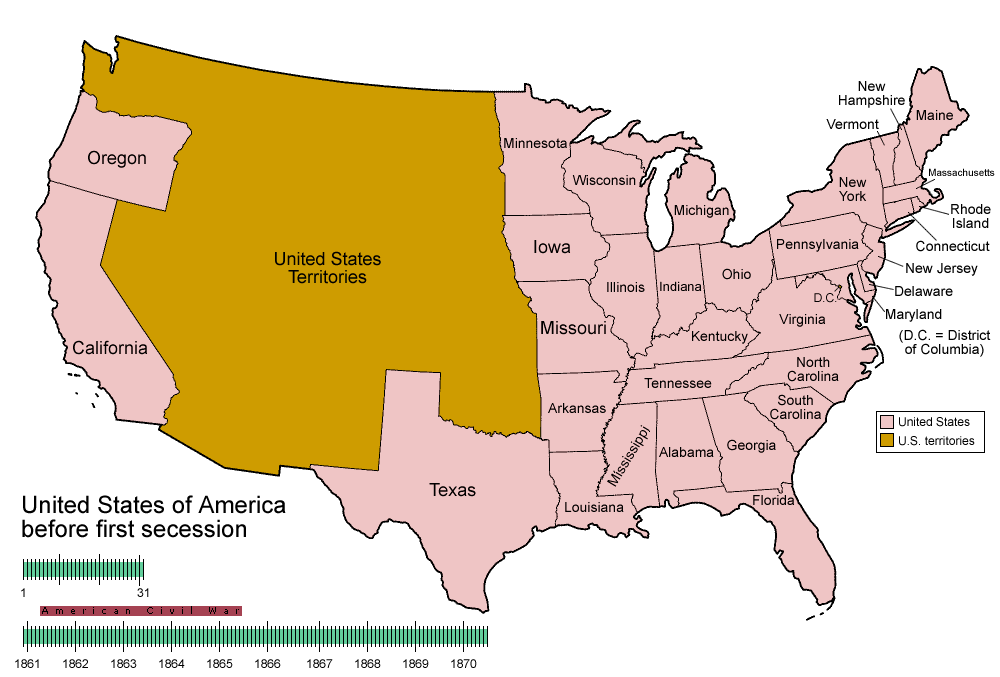
| Description | Animated map/timeline of the territorial evolution of the Confederate States of America, from first secession to end of Reconstruction. |
| Date | |
| Source | Travail personnel |
| Auteur | User:Golbez |
|
Conditions d’utilisation
[modifier]
Moi, en tant que détenteur des droits d’auteur sur cette œuvre, je la publie sous les licences suivantes :

|
Vous avez la permission de copier, distribuer et modifier ce document selon les termes de la GNU Free Documentation License version 1.2 ou toute version ultérieure publiée par la Free Software Foundation, sans sections inaltérables, sans texte de première page de couverture et sans texte de dernière page de couverture. Un exemplaire de la licence est inclus dans la section intitulée GNU Free Documentation License. |
| Ce fichier est disponible selon les termes de la licence Creative Commons Attribution – Partage dans les Mêmes Conditions 3.0 (non transposée). | ||
| ||
| Ce bandeau de licence a été ajouté à ce fichier dans le cadre de la procédure de mise à jour des licences des images sous GFDL. |
Ce fichier est sous licence Creative Commons Attribution – Partage dans les Mêmes Conditions 2.5 Générique, 2.0 Générique et 1.0 Générique.
- Vous êtes libre :
- de partager – de copier, distribuer et transmettre cette œuvre
- d’adapter – de modifier cette œuvre
- Sous les conditions suivantes :
- paternité – Vous devez donner les informations appropriées concernant l'auteur, fournir un lien vers la licence et indiquer si des modifications ont été faites. Vous pouvez faire cela par tout moyen raisonnable, mais en aucune façon suggérant que l’auteur vous soutient ou approuve l’utilisation que vous en faites.
- partage à l’identique – Si vous modifiez, transformez, ou vous basez sur cette œuvre, vous devez distribuer votre contribution sous la même licence ou une licence compatible avec celle de l’original.
Vous pouvez choisir l’une de ces licences.
Historique du fichier
Cliquer sur une date et heure pour voir le fichier tel qu'il était à ce moment-là.
| Date et heure | Vignette | Dimensions | Utilisateur | Commentaire | |
|---|---|---|---|---|---|
| actuel | 5 juin 2014 à 05:30 | | 1 000 × 677 (245 kio) | RedXIV (d | contributions) | Removed incorrect information. Kentucky and Missouri never seceded. The state governments of Kentucky and Missouri never voted to secede. Claiming that their secession actually happened gives an inaccurate impression of the actual sequence of events. |
| 21 décembre 2013 à 10:56 |  | 1 000 × 677 (256 kio) | ChrisnHouston (d | contributions) | I'm the one who broke the thumbnail. I'll try to fix it now... | |
| 20 décembre 2013 à 13:38 |  | 1 000 × 677 (1,75 Mio) | Afernand74 (d | contributions) | No image displayed. Reupload to try to solve the problem | |
| 7 novembre 2013 à 11:33 |  | 1 000 × 677 (1,75 Mio) | ChrisnHouston (d | contributions) | Adding a bar to the timeline to indicate when the actual fighting of the Civil War happened, which is one of the most important aspects of this map. | |
| 11 avril 2012 à 15:18 |  | 1 000 × 677 (254 kio) | Golbez (d | contributions) | rv - er, MO and KY were indeed admitted to the CSA, though it lacked any control over them. why not go to the talk page for the CSA on enwp and chat about my next version? | |
| 10 avril 2012 à 18:53 |  | 1 000 × 677 (225 kio) | Travürsa (d | contributions) | Fixed errors. | |
| 18 novembre 2007 à 01:57 |  | 1 000 × 677 (254 kio) | Golbez (d | contributions) | Removing frame of WV counties; that was incorrect, they were always part of WV | |
| 4 mars 2007 à 09:54 |  | 1 000 × 677 (259 kio) | Golbez (d | contributions) | == Summary == {{Information |Description=Animated map/timeline of the territorial evolution of the Confederate States of America, from first secession to end of Reconstruction. |Source=Self-made. |Date=March 2007 |Author=User:Golbez |Permission= see b |
Vous ne pouvez pas remplacer ce fichier.
Utilisations locales du fichier
Aucune page n’utilise ce fichier.
Utilisations du fichier sur d’autres wikis
Les autres wikis suivants utilisent ce fichier :
- Utilisation sur af.wikipedia.org
- Utilisation sur bcl.wikipedia.org
- Utilisation sur cs.wikipedia.org
- Utilisation sur da.wikipedia.org
- Utilisation sur de.wikipedia.org
- Utilisation sur en.wikipedia.org
- Confederate States of America
- History of the United States
- Portal:United States/Selected picture
- User talk:-asx-
- User talk:Golbez/Archive 2
- Portal:Maps/Selected picture
- Wikipedia:Featured picture candidates/March-2007
- Wikipedia:Picture peer review/CSA evolution
- Wikipedia:Featured picture candidates/CSA states evolution.gif
- Wikipedia:Wikipedia Signpost/2007-03-20/Features and admins
- Wikipedia:Wikipedia Signpost/2007-03-20/SPV
- Portal:Maps/Selected picture/11
- Portal:United States/Selected picture/15
- Wikipedia:Featured picture candidates/November-2009
- Wikipedia:Featured picture candidates/Non-Native American Nations Control over N America 1750-2008.gif
- Wikipedia:Featured picture candidates/delist/2010
- Wikipedia:Featured picture candidates/delist/File:CSA states evolution.gif
- User:TheVirginiaHistorian/sandbox
- Wikipedia:Village pump (technical)/Archive 110
- Wikipedia:Wikipedia Signpost/Single/2007-03-20
- User:Falcaorib/Canada, United States and Mexico
- Utilisation sur eo.wikipedia.org
- Utilisation sur eu.wikipedia.org
- Utilisation sur fr.wikipedia.org
- Utilisation sur fr.wiktionary.org
- Utilisation sur fy.wikipedia.org
- Utilisation sur hr.wikipedia.org
- Utilisation sur hu.wikipedia.org
- Utilisation sur id.wikipedia.org
- Utilisation sur ja.wikipedia.org
- Utilisation sur la.wikipedia.org
- Utilisation sur ms.wikipedia.org
- Utilisation sur pt.wikipedia.org
- Utilisation sur ro.wikipedia.org
- Utilisation sur sr.wikipedia.org
- Utilisation sur th.wikipedia.org
- Utilisation sur tr.wikipedia.org
Voir davantage sur l’utilisation globale de ce fichier.