File:CSO map EPA 2008.jpg
Jump to navigation
Jump to search
No higher resolution available.
CSO_map_EPA_2008.jpg (407 × 221 pixels, file size: 27 KB, MIME type: image/jpeg)
Captions
Captions
Add a one-line explanation of what this file represents

|
This map image could be re-created using vector graphics as an SVG file. This has several advantages; see Commons:Media for cleanup for more information. If an SVG form of this image is available, please upload it and afterwards replace this template with
{{vector version available|new image name}}.
It is recommended to name the SVG file “CSO map EPA 2008.svg”—then the template Vector version available (or Vva) does not need the new image name parameter. |


Summary
[edit]
| Description |
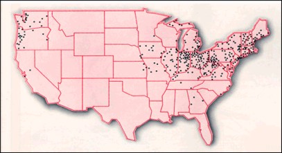
English: Map of United States indicating cities and towns with combined sewer systems. "Combined sewer systems serve roughly 772 communities containing about 40 million people." |
| Date | |
| Source | U.S. Environmental Protection Agency, Washington, D.C. "Combined Sewer Overflows Demographics." |
| Author | U.S. Environmental Protection Agency (EPA) |
Licensing
[edit]
This image (or other media) is a work of an Environmental Protection Agency employee, taken or made as part of that person's official duties. As works of the U.S. federal government, all EPA images are in the public domain.
|
||
File history
Click on a date/time to view the file as it appeared at that time.
| Date/Time | Thumbnail | Dimensions | User | Comment | |
|---|---|---|---|---|---|
| current | 03:37, 3 July 2014 | | 407 × 221 (27 KB) | Moreau1 (talk | contribs) | == {{int:filedesc}} == {{Information |Description={{en|Map of United States indicating cities and towns with {{w|combined sewer}} systems. "Combined sewer systems serve roughly 772 communities containing about 40 million people."}} |Source=U.S. Environ... |
You cannot overwrite this file.
File usage on Commons
There are no pages that use this file.
File usage on other wikis
The following other wikis use this file:
- Usage on en.wikipedia.org